চিত্র:Deutschesreich1939.png
From Wikipedia, the free encyclopedia
এই প্রাকদর্শনের আকার: ৭৬৪ × ৬০০ পিক্সেল। অন্যান্য আকারসমূহ: ৩০৬ × ২৪০ পিক্সেল | ৬১২ × ৪৮০ পিক্সেল | ৯৭৯ × ৭৬৮ পিক্সেল | ১,০৩২ × ৮১০ পিক্সেল।
পূর্ণ রেজোলিউশন (১,০৩২ × ৮১০ পিক্সেল, ফাইলের আকার: ২৬২ কিলোবাইট, এমআইএমই ধরন: image/png)
| এই ফাইলটি উইকিমিডিয়া কমন্স থেকে নেওয়া। সেখানের বর্ণনা পাতার বিস্তারিত নিম্নে দেখানো হলো। (সম্পাদনা)
|
| বিবরণDeutschesreich1939.png |
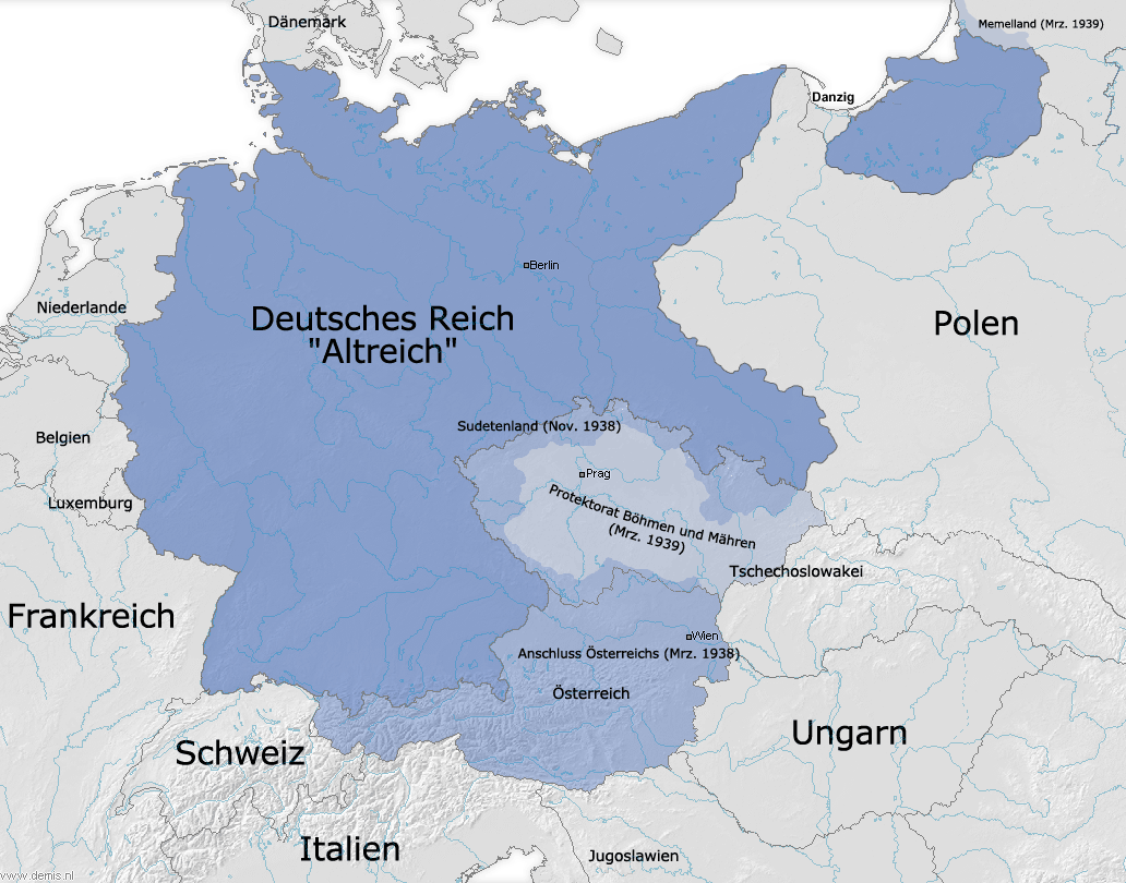
Deutsch: Die Grenzen des Deutschen Reiches (Altreich) am 31. 12. 1937 und Ausdehnungen 1938/1939 |
|||
| উৎস | নিজের কাজ ও Demis | |||
| লেখক | FJ-de | |||
| অনুমতি (এ ফাইলের পুনঃব্যবহার) |
|
|||
| অন্যান্য সংস্করণ |
|
.png)

|
This historical map image could be re-created using vector graphics as an SVG file. This has several advantages; see Commons:Media for cleanup for more information. If an SVG form of this image is available, please upload it and afterwards replace this template with
{{vector version available|new image name}}.
It is recommended to name the SVG file “Deutschesreich1939.svg”—then the template Vector version available (or Vva) does not need the new image name parameter. |
ক্যাপশন
এই ফাইল কি প্রতিনিধিত্ব করছে তার এক লাইন ব্যাখ্যা যোগ করুন
Germany's (Altreich) borders as of 31 December 1937, and subsequent expansion before WWII.
Les frontières de l'Allemagne (Altreich) à compter du 31 décembre 1937 et son expansion ultérieure avant la Seconde Guerre mondiale.
এই ফাইলে চিত্রিত আইটেমগুলি
যা চিত্রিত করে
কিছু মানের উইকিউপাত্ত আইটেম নেই
image/png
ফাইলের ইতিহাস
যেকোনো তারিখ/সময়ে ক্লিক করে দেখুন ফাইলটি তখন কী অবস্থায় ছিল।
| তারিখ/সময় | সংক্ষেপচিত্র | মাত্রা | ব্যবহারকারী | মন্তব্য | |
|---|---|---|---|---|---|
| বর্তমান | ১১:৪০, ৩ অক্টোবর ২০০৯ | | ১,০৩২ × ৮১০ (২৬২ কিলোবাইট) | NordNordWest | |
| ১০:১২, ২৯ সেপ্টেম্বর ২০০৯ |  | ১,০৩২ × ৮১০ (২৬২ কিলোবাইট) | NordNordWest | ||
| ১৮:৪৭, ১১ জানুয়ারি ২০০৯ |  | ১,০৩২ × ৮১০ (২৫৯ কিলোবাইট) | NordNordWest | + Danzig | |
| ১৭:১৯, ১৮ নভেম্বর ২০০৮ |  | ১,০৩২ × ৮১০ (২৫৯ কিলোবাইট) | NordNordWest | some corrections | |
| ১৬:১০, ২৮ নভেম্বর ২০০৫ |  | ১,০৩২ × ৮১০ (২৮৭ কিলোবাইট) | FJ-de | Karte ist erstellt von mir - Vorlage Demis http://www.demis.nl/wms/mapclip.htm |
সংযোগসমূহ
এই ফাইল ব্যবহার করে এমন কোনো পাতা নেই।
ফাইলের বৈশ্বিক ব্যবহার
নিচের অন্যান্য উইকিগুলো এই ফাইলটি ব্যবহার করে:
- af.wikipedia.org-এ ব্যবহার
- azb.wikipedia.org-এ ব্যবহার
- be.wikipedia.org-এ ব্যবহার
- ca.wikipedia.org-এ ব্যবহার
- cs.wikipedia.org-এ ব্যবহার
- da.wikipedia.org-এ ব্যবহার
- de.wikipedia.org-এ ব্যবহার
- en.wikipedia.org-এ ব্যবহার
- eo.wikipedia.org-এ ব্যবহার
- es.wikipedia.org-এ ব্যবহার
- et.wikipedia.org-এ ব্যবহার
- fi.wikipedia.org-এ ব্যবহার
- fi.wikibooks.org-এ ব্যবহার
- fr.wikipedia.org-এ ব্যবহার
- hu.wikipedia.org-এ ব্যবহার
- it.wikipedia.org-এ ব্যবহার
- lb.wikipedia.org-এ ব্যবহার
- nov.wikipedia.org-এ ব্যবহার
- no.wikipedia.org-এ ব্যবহার
- pl.wikipedia.org-এ ব্যবহার
- ro.wikipedia.org-এ ব্যবহার
- ru.wikipedia.org-এ ব্যবহার
- sh.wikipedia.org-এ ব্যবহার
- simple.wikipedia.org-এ ব্যবহার
- sk.wikipedia.org-এ ব্যবহার
- sv.wikipedia.org-এ ব্যবহার
- zh.wikipedia.org-এ ব্যবহার