चित्र:Koppen_World_Map_Cwa_Cfa.png
From Wikipedia, the free encyclopedia
ए नमूना के साइज: 800 × 490 पिक्सेल. अउरी रिजोल्यूशन: 320 × 196 पिक्सेल | 640 × 392 पिक्सेल | 1,024 × 627 पिक्सेल | 1,280 × 784 पिक्सेल | 2,560 × 1,568 पिक्सेल | 4,231 × 2,592 पिक्सेल.
ओरिजनल फाइल (4,231 × 2,592 पिक्सेल, फाइल साइज: 1.52 MB, MIME टाइप: image/png)
ई फाइल Wikimedia Commons से बा आ अउरी प्रोजेक्ट भी एकर इस्तेमाल कर सकत बाड़ें। एकर विवरण फाइल विवरण पन्ना नीचे देखावल गइल बा।

|
This meteorology image could be re-created using vector graphics as an SVG file. This has several advantages; see Commons:Media for cleanup for more information. If an SVG form of this image is available, please upload it and afterwards replace this template with
{{vector version available|new image name}}.
It is recommended to name the SVG file “Koppen World Map Cwa Cfa.svg”—then the template Vector version available (or Vva) does not need the new image name parameter. |
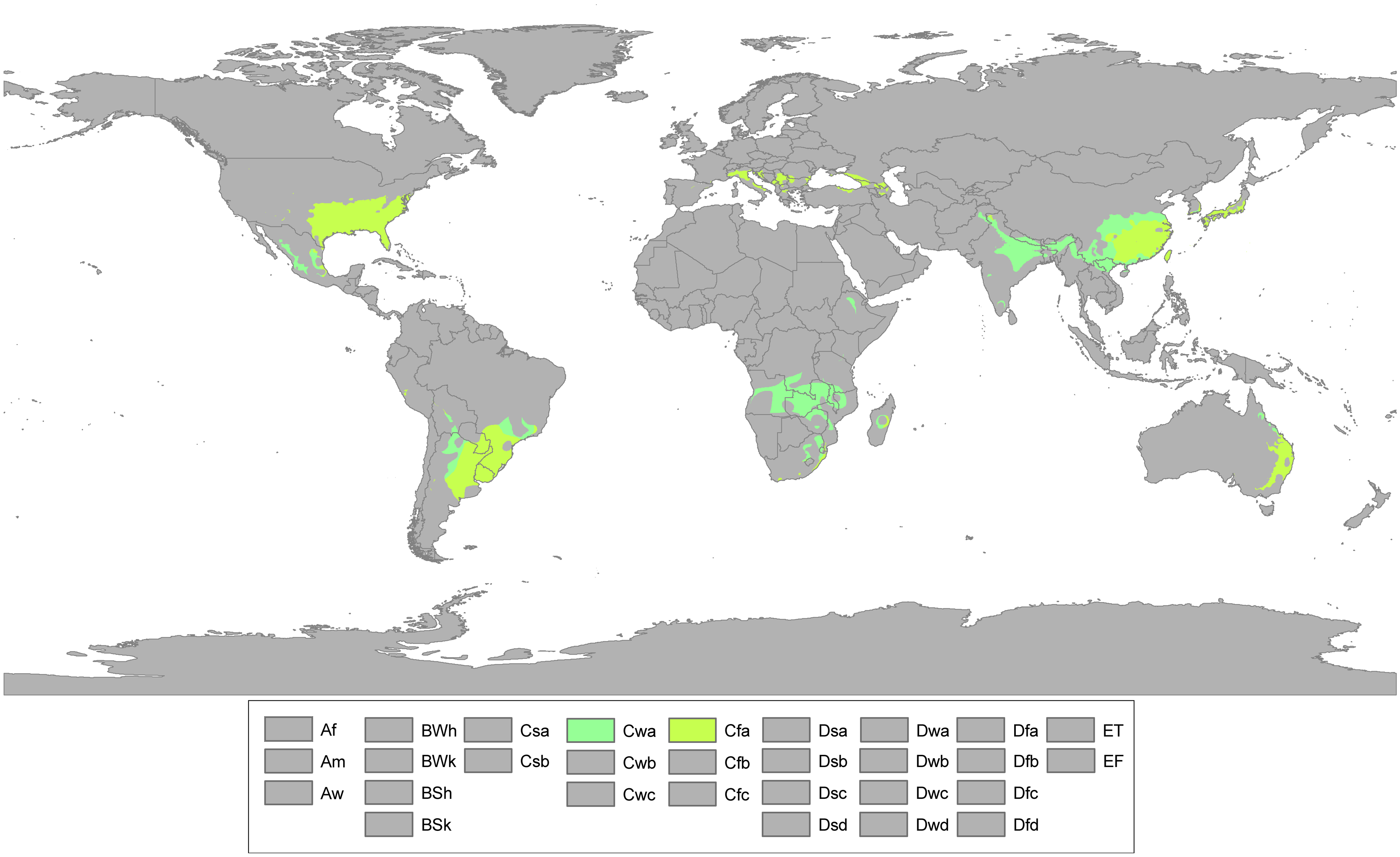
| बिबरणKoppen World Map Cwa Cfa.png |
English: Updated world map of the Köppen-Geiger climate classification. Humid subtropical climates (Cfa, Cwa) |
| तारीख | (UTC) |
| स्रोत | |
| लेखक |
|
| This is a retouched picture, which means that it has been digitally altered from its original version. Modifications: mentioned above +scaled down. The original can be viewed here: Koppen World Map Hi-Res.png:
|
I, the copyright holder of this work, hereby publish it under the following license:
ई फाइल Creative Commons Attribution-Share Alike 3.0 Unported लाइसेंस की तहत लाइसेंसी बा।
- आप फ्री बानी:
- साझा करे खातिर – रचना के नकल करे, बाँटे आ दुसरी जगह भेजे खातिर
- रीमिक्स करे खातिर – काम के अपनी हिसाब से बनावे खातिर
- नीचे दिहल कारणन की तहत:
- एट्रीब्यूशन – लाइसेंस के कड़ी दे के उचित श्रेय (क्रेडिट) दिहल जरूरी बा आ अगर कौनों बदलाव कइल गइल बा तब ओहू के बतावल जाए के चाहीं। आप ई काम कौनों उचित तरीका से क सकत बानी, बाकी ई न झलके के चाहीं की जेकरा लगे लाइसेंस बा ऊ राउर चाहे राउर काम के समर्थन करत बाटे या सही बतावत बा।
- शेयर अलाइक (share alike) – अगर आप एह सामग्री के आधार बना के कुछ रिमिक्स करत बानी, रूप बदलाव करत बानी, चाहे कुछ जोड़ के सामग्री के बढ़ावत बानी, आपके आपन योगदान ठीक एही या कंपेटिबल लाइसेंस जइसन कि ओरिजनल बाटे, के तहत होखे के चाहीं।
Original upload log
This image is a derivative work of the following images:
- File:Koppen_World_Map_Hi-Res.png licensed with Cc-by-sa-3.0
- 2011-03-31T22:59:14Z Me ne frego 12047x7383 (1118685 Bytes) More white spots to grey
- 2011-03-31T21:38:00Z Me ne frego 12047x7383 (1119503 Bytes) White spots changed to grey, Caspian Sea to white
- 2011-03-31T17:35:02Z Me ne frego 12047x7383 (1116191 Bytes) {{Information |Description ={{en|1=Updated world map of the Köppen-Geiger climate classification without anti-alising, high resolution.}} |Source =[http://hal.archives-ouvertes.fr/docs/00/29/88/18/PDF/hessd-4-439-
Uploaded with derivativeFX
Captions
Add a one-line explanation of what this file represents
Location map of Humid subtropical climates
Items portrayed in this file
depicts अंगरेजी
copyright status अंगरेजी
copyrighted अंगरेजी
inception अंगरेजी
४ अप्रैल 2011
media type अंगरेजी
image/png
फाइल के इतिहास
ओ समय ई फाइल कइसन लउके ई देखे खातिर कौनों तारीख/समय पर क्लिक करीं।
| तारीख/समय | चिप्पी रूप | डाइमेंशन | प्रयोगकर्ता | टिप्पणी | |
|---|---|---|---|---|---|
| वर्तमान | 21:41, 26 मई 2015 | | 4,231 × 2,592 (1.52 MB) | Carnby | South Sudan border |
| 19:56, 4 नवंबर 2011 |  | 4,231 × 2,592 (1.57 MB) | Surfmann~commonswiki | Cfa is absent of Germany or Eastern France | |
| 07:47, 4 अप्रैल 2011 |  | 4,231 × 2,592 (1.53 MB) | Me ne frego | {{Information |Description={{en|1=Updated world map of the Köppen-Geiger climate classification. '''Humid subtropical climates (Cfa, Cwa)'''}} |Source=*File:Koppen_World_Map_Hi-Res.png |Date=2011-04-04 07:44 (UTC) |Author=*[[:File:Koppen_World_Map_ |
फाइल के उपयोग
फाइल के इस्तेमाल पन्ना करत बा:
बैस्विक फाइल उपयोग
नीचे दिहल अउरी विकिसभ पर एह फाइल के इस्तेमाल हो रहल बा:
- ar.wikipedia.org पर इस्तेमाल
- bg.wikipedia.org पर इस्तेमाल
- ca.wikipedia.org पर इस्तेमाल
- cs.wikipedia.org पर इस्तेमाल
- de.wikipedia.org पर इस्तेमाल
- el.wikipedia.org पर इस्तेमाल
- en.wikipedia.org पर इस्तेमाल
- fa.wikipedia.org पर इस्तेमाल
- he.wikipedia.org पर इस्तेमाल
- id.wikipedia.org पर इस्तेमाल
- io.wikipedia.org पर इस्तेमाल
- ja.wikipedia.org पर इस्तेमाल
- ja.wikibooks.org पर इस्तेमाल
- kab.wikipedia.org पर इस्तेमाल
- lt.wikipedia.org पर इस्तेमाल
- nl.wikipedia.org पर इस्तेमाल
- nn.wikipedia.org पर इस्तेमाल
- oc.wikipedia.org पर इस्तेमाल
- pt.wikipedia.org पर इस्तेमाल
- ro.wikipedia.org पर इस्तेमाल
- ru.wikipedia.org पर इस्तेमाल
- sh.wikipedia.org पर इस्तेमाल
- simple.wikipedia.org पर इस्तेमाल
- sr.wikipedia.org पर इस्तेमाल
- sv.wikipedia.org पर इस्तेमाल
- th.wikipedia.org पर इस्तेमाल
- tr.wikipedia.org पर इस्तेमाल
- uk.wikipedia.org पर इस्तेमाल
- vi.wikipedia.org पर इस्तेमाल
- zh.wikipedia.org पर इस्तेमाल
- zu.wikipedia.org पर इस्तेमाल
मेटाडाटा
ए फाइल में एक्स्ट्रा जानकारी उपलब्ध बा, हो सकत बा कि ई डिजिटल कैमरा या स्कैनर से लेवल गइल होखे। अगर ई वर्तमान फाइल एकरी ओरिजनल फाइल से सुधार के बनल बा त हो सकेला कुछ जानकारी ना लउके।
| Horizontal resolution | 37.8 dpc |
|---|---|
| Vertical resolution | 37.8 dpc |
| File change date and time | 21:39, 26 मई 2015 |