File:Scotland_Administrative_Map_1947.png
From Wikipedia, the free encyclopedia
ए नमूना के साइज: 345 × 600 पिक्सेल. अउरी रिजोल्यूशन: 138 × 240 पिक्सेल | 276 × 480 पिक्सेल | 441 × 768 पिक्सेल | 589 × 1,024 पिक्सेल | 2,001 × 3,480 पिक्सेल.
ओरिजनल फाइल (2,001 × 3,480 पिक्सेल, फाइल साइज: 2.32 MB, MIME टाइप: image/png)
ई फाइल Wikimedia Commons से बा आ अउरी प्रोजेक्ट भी एकर इस्तेमाल कर सकत बाड़ें। एकर विवरण फाइल विवरण पन्ना नीचे देखावल गइल बा।
सारांश
| बिबरणScotland Administrative Map 1947.png |
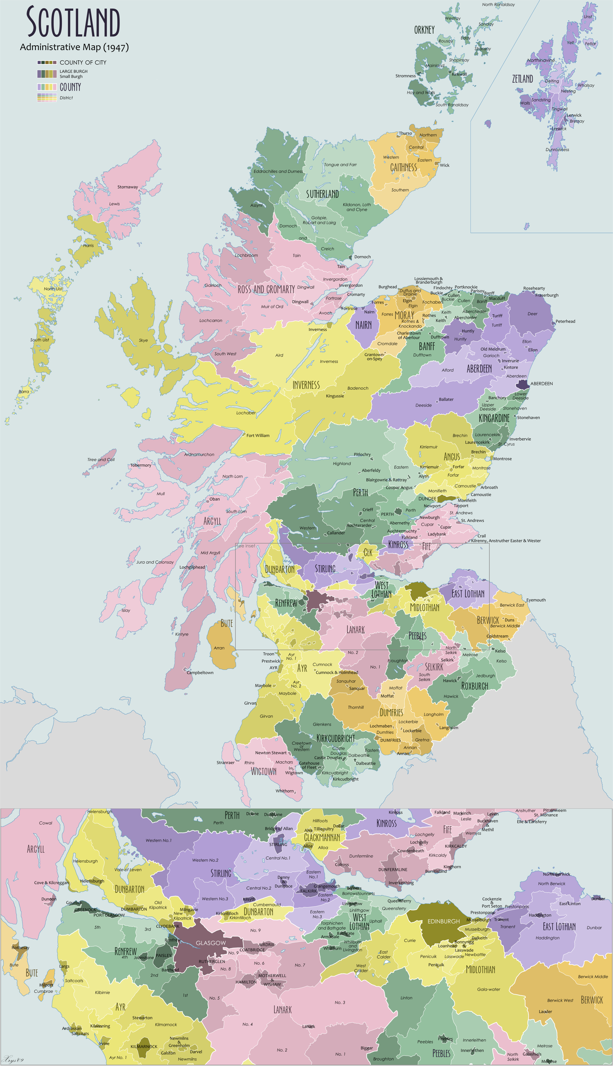
English: Administrative map of Scotland in 1947. Showing counties and districts, counties of cities, large and small Burghs |
| तारीख | |
| स्रोत | आपन रचना |
| लेखक | XrysD |
| Other versions |
Derivative works of this file: |
लाइसेंसिंग
I, the copyright holder of this work, hereby publish it under the following licenses:

|
जीएनयू फ्री डाकुमेंटेशन लाइसेंस, वर्जन 1.2 या फिर कौनो भी बाद के प्रकाशित फ्री साफ्टवेयर फाउंडेशन लाइसेंस के शर्त के तहत, एह डाकुमेंट के नकल करे, बितरण करे आ/भा बदलाव करे के परमीशन दिहल गइल बा; एह में इनवैरिएंट खंड सभ नइखे शामिल, मुखपृष्ट के पाठ नइखे शामिल, आ बैक-कभर के पाठ नइखे शामिल। लाइसेंस के एगो प्रति जीएनयू फ्री डाकुमेंटेशन लाइसेंस नाँव के खंड में दिहल गइल बा।http://www.gnu.org/copyleft/fdl.htmlGFDLGNU Free Documentation Licensetruetrue |
| ई फाइल Creative Commons Attribution-Share Alike 3.0 Unported लाइसेंस की तहत लाइसेंसी बा। | ||
| ||
| This licensing tag was added to this file as part of the GFDL licensing update.http://creativecommons.org/licenses/by-sa/3.0/CC BY-SA 3.0Creative Commons Attribution-Share Alike 3.0truetrue |
| Copyleft: This work of art is free; you can redistribute it and/or modify it according to terms of the Free Art License. You will find a specimen of this license on the Copyleft Attitude site as well as on other sites. http://artlibre.org/licence/lal/enFALFree Art Licensefalsetrue |
रउआँ अपनी जरूरत के लाइसेंस बीछ सकत बानीं।
Captions
Add a one-line explanation of what this file represents
1947 administrative regions of Scotland
Items portrayed in this file
depicts अंगरेजी
creator अंगरेजी
some value
copyright status अंगरेजी
copyrighted अंगरेजी
source of file अंगरेजी
original creation by uploader अंगरेजी
inception अंगरेजी
१४ जून 2009
फाइल के इतिहास
ओ समय ई फाइल कइसन लउके ई देखे खातिर कौनों तारीख/समय पर क्लिक करीं।
| तारीख/समय | चिप्पी रूप | डाइमेंशन | प्रयोगकर्ता | टिप्पणी | |
|---|---|---|---|---|---|
| वर्तमान | 11:05, 10 नवंबर 2012 | | 2,001 × 3,480 (2.32 MB) | XrysD | Fixed typo Borrowstouness->Borrowstounness |
| 12:39, 14 जून 2009 |  | 2,000 × 3,479 (2.56 MB) | XrysD | Corrected typo | |
| 12:04, 14 जून 2009 |  | 2,000 × 3,479 (2.55 MB) | XrysD | {{Information |Description={{en|1=Administrative map of Scotland in 1947. Showing Counties and Districts, Counties of Cities, Large and Smal Burghs}} |Source=Own work by uploader |Author=XrysD |Date=2009-06-14 |Permission= |other_versions= |
फाइल के उपयोग
कौनों पन्ना नइखे जवन ए फाइल के इस्तेमाल करत होखे।
बैस्विक फाइल उपयोग
नीचे दिहल अउरी विकिसभ पर एह फाइल के इस्तेमाल हो रहल बा:
- de.wikipedia.org पर इस्तेमाल
- en.wikipedia.org पर इस्तेमाल
- es.wikipedia.org पर इस्तेमाल
- it.wikipedia.org पर इस्तेमाल
- pl.wikipedia.org पर इस्तेमाल
- sl.wikipedia.org पर इस्तेमाल
- tr.wikipedia.org पर इस्तेमाल
- www.wikidata.org पर इस्तेमाल
- zh.wikipedia.org पर इस्तेमाल
मेटाडाटा
ए फाइल में एक्स्ट्रा जानकारी उपलब्ध बा, हो सकत बा कि ई डिजिटल कैमरा या स्कैनर से लेवल गइल होखे। अगर ई वर्तमान फाइल एकरी ओरिजनल फाइल से सुधार के बनल बा त हो सकेला कुछ जानकारी ना लउके।
| Horizontal resolution | 18.9 dpc |
|---|---|
| Vertical resolution | 18.9 dpc |