Файл:Yugoslavia_Ethnic_1940.jpg
From Wikipedia, the free encyclopedia
Размер на този преглед: 643 × 599 пиксела. Други разделителни способности: 258 × 240 пиксела | 515 × 480 пиксела | 824 × 768 пиксела | 1099 × 1024 пиксела | 2416 × 2252 пиксела.
Оригинален файл (2416 × 2252 пиксела, големина на файла: 970 КБ, MIME-тип: image/jpeg)
| Този файл е от Общомедия и може да се използва от други проекти.
Следва информация за файла, достъпна през оригиналната му описателна страница. |

|
Това изображение (или всички изображения в тази страница/категория) би трябвало да бъдат пресъздадени с използване на векторна графика във формат SVG. Това има няколко предимства; вижте Commons:Media for cleanup за повече информация. Ако разполагате с това избражение в SVG формат, моля качете го. След това заместете този шаблон с {{Vector version available|име на новия файл.svg}}.
|
 | This historical map image was uploaded in the JPEG format even though it consists of non-photographic data. This information could be stored more efficiently or accurately in the PNG or SVG format. If possible, please upload a PNG or SVG version of this image without compression artifacts, derived from a non-JPEG source (or with existing artifacts removed). After doing so, please tag the JPEG version with {{Superseded|NewImage.ext}} and remove this tag. This tag should not be applied to photographs or scans. If this image is a diagram or other image suitable for vectorisation, please tag this image with {{Convert to SVG}} instead of {{BadJPEG}}. If not suitable for vectorisation, use {{Convert to PNG}}. For more information, see {{BadJPEG}}. |  |
Резюме
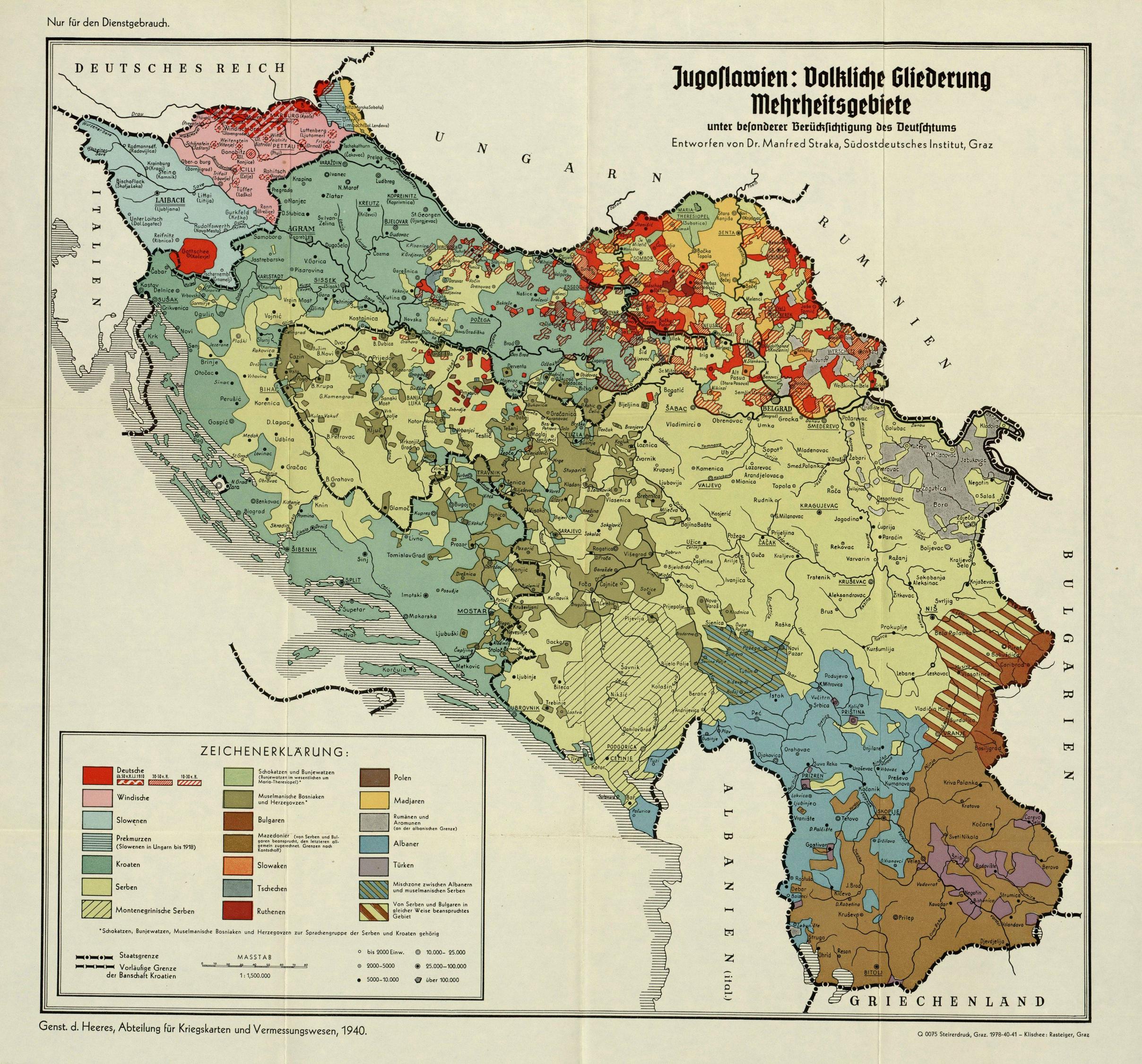
| ОписаниеYugoslavia Ethnic 1940.jpg |
English: Ethnic Map of Kingdom of Yugoslavia, 1940 |
| Дата | |
| Източник | http://geographie.ipt.univ-paris8.fr/rubriks/carto/cartorub/cartes/cartesnum/34957.jpg |
| Автор | Generalstab des Heeres, Abteilung für Kriegskarten und Vermessungswesen; Dr. Manfred Straka (1911-1990), Südostdeutsches Institut Graz |
Лицензиране
This work is an Ordnance Survey map over 50 years old, which is covered by Crown Copyright which in this case expires 50 years after publication. Ordnance Survey does however ask that they be credited and that the date of publication be given.
Any ancillary rights gained through the creation of the electronic version are granted as freely usable under any circumstances.
|
| Public domainPublic domainfalsefalse |
This work created by the United Kingdom Government is in the public domain.
This is because it is one of the following:
HMSO has declared that the expiry of Crown Copyrights applies worldwide (ref: HMSO Email Reply) Deutsch ∙ English ∙ Español ∙ français ∙ italiano ∙ Nederlands ∙ polski ∙ português ∙ sicilianu ∙ slovenščina ∙ suomi ∙ Türkçe ∙ македонски ∙ русский ∙ українська ∙ മലയാളം ∙ 한국어 ∙ 日本語 ∙ 简体中文 ∙ 繁體中文 ∙ العربية ∙ +/− |
 |
Описания
Add a one-line explanation of what this file represents
Items portrayed in this file
изобразен обект
История на файла
Избирането на дата/час ще покаже как е изглеждал файлът към онзи момент.
| Дата/Час | Миникартинка | Размер | Потребител | Коментар | |
|---|---|---|---|---|---|
| текуща | 17:13, 14 април 2017 | | 2416 × 2252 (970 КБ) | Bojovnik | User created page with UploadWizard |
Използване на файла
Следната страница използва следния файл:
Глобално използване на файл
Този файл се използва от следните други уикита:
- Употреба в de.wikipedia.org
- Употреба в en.wikipedia.org
- Употреба в fa.wikipedia.org
- Употреба в fr.wikipedia.org
- Употреба в mk.wikipedia.org
- Употреба в pt.wikipedia.org
- Употреба в sl.wikipedia.org
- Употреба в sq.wikipedia.org
- Употреба в sr.wikipedia.org
- Употреба в uk.wikipedia.org
- Употреба в zh.wikipedia.org