Файл:Rhinocerotidae_distribution_map.png
From Wikipedia, the free encyclopedia
Памер папярэдняга прагляду: 800 × 501 пікселяў. Іншыя разрозненні: 320 × 200 пікселяў | 640 × 401 пікселяў | 1 024 × 641 пікселяў | 1 499 × 939 пікселяў.
Арыгінальны файл (1 499 × 939 кропак, аб’ём файла: 152 KB, тып MIME: image/png)
Гэты файл з на Вікісховішчы і можа выкарыстоўвацца іншымі праектамі. Апісанне на яго старонцы ў Wikimedia Commons прыведзена ніжэй.
Тлумачэнне
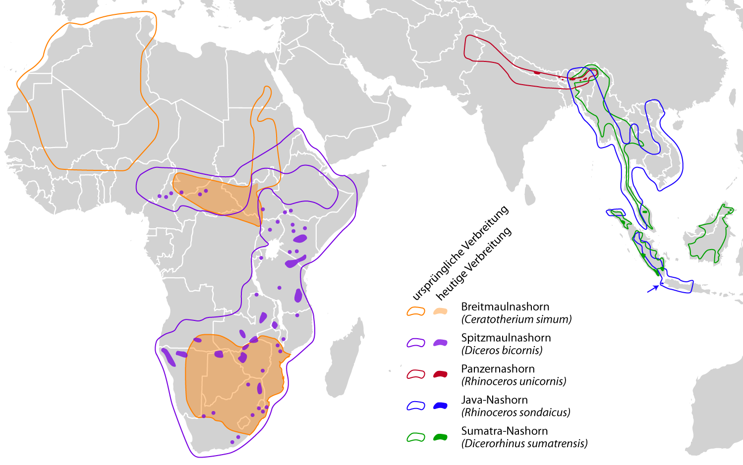
| АпісаннеRhinocerotidae distribution map.png |
Deutsch: Verbreitungskarte der Nashörner
English: Rhinoceros distribution map |
| Дата | (UTC) |
| Крыніца |
This file was derived from: |
| Аўтар |
|
Ліцэнзіяванне
Гэты файл даступны па ліцэнзіі Creative Commons Пазначэнне аўтарства - На тых самых умовах 3.0 Непартаваная
- Вы можаце свабодна:
- дзяліцца творам – капіраваць, распаўсюджваць і перадаваць гэты твор.
- ствараць вытворныя творы – адаптаваць гэты твор
- Пры выкананні наступных умоў:
- атрыбуцыя – вы павінны пазначыць аўтарства гэтага твора, даць спасылку на ліцэнзію і пазначыць ці рабіў аўтар якія-небудзь змены. Гэта можна рабіць кожным зразумелым чынам, але не так, каб наводзіць па думку, што ліцэнзіят падтрымлівае вас або выкарыстанне вамі гэтага твора.
- распаўсюджванне на тых жа ўмовах – Калі вы змяняеце, адаптуеце ці ствараеце вытворны твор на аснове гэтага, то павінны распаўсюджваць атрыманы ў выніку твор на ўмовах такой самай ці сумяшчальнай ліцэнзіі, што і арыгінал.
Журнал арыгінальнай загрузкі
This image is a derivative work of the following images:
- File:BlankMap-World6.svg licensed with PD-self
- 2012-02-14T13:37:02Z Tentotwo 863x443 (1609186 Bytes) Removed hardcoded styles from sd, ss, and cf
- 2012-01-06T03:22:35Z Spesh531 863x443 (1651067 Bytes) Fixing South Sudan's border
- 2011-12-19T00:04:12Z Chipmunkdavis 863x443 (1612580 Bytes) Reverted to version as of 00:51, 27 August 2011
- 2011-12-18T15:14:45Z Anshulkumardhiman 1920x1080 (320804 Bytes) fixed background
- 2011-12-18T15:06:50Z Anshulkumardhiman 1920x1080 (323987 Bytes) fixed color texture
- 2011-08-27T00:51:14Z Anomie 863x443 (1612580 Bytes) South Sudan has been assigned code SS, so use that code.
- 2011-07-30T18:04:36Z Lokal Profil 863x443 (1612578 Bytes) Minor circle related changes and remove the legacy pentagram
- 2011-07-08T23:26:24Z NuclearVacuum 863x443 (1613386 Bytes) South Sudan is free!! Hooray
- 2011-07-04T20:41:30Z NuclearVacuum 863x443 (1615589 Bytes) Restored to previous version, as SS isn't independent yet. But the code is now ready and waiting
- 2011-07-04T20:40:06Z NuclearVacuum 863x443 (1613386 Bytes) Separated South Sudan from (North) Sudan in preparation for SS independence on July 9, 2011.
- 2011-06-27T15:15:14Z Canuckguy 863x443 (1615589 Bytes) restored PR, set id labels for West Bank and Gaza
- 2011-04-01T14:09:57Z NuclearVacuum 863x443 (1614917 Bytes) Mayotte is now a department of France
- 2011-02-17T14:31:36Z NuclearVacuum 863x443 (1614903 Bytes) minor fixes
- 2011-02-13T01:43:20Z Canuckguy 863x443 (1632654 Bytes) minor fix
- 2011-01-22T20:16:24Z NuclearVacuum 863x443 (1614900 Bytes) added lakes
- 2011-01-22T20:12:02Z NuclearVacuum 863x443 (1632622 Bytes) ...
- 2011-01-22T20:08:04Z NuclearVacuum 863x443 (1632651 Bytes) Reverted to version as of 18:31, 17 January 2011
- 2011-01-22T20:07:39Z NuclearVacuum 1173x937 (334238 Bytes) just testing something
- 2011-01-17T18:31:33Z NuclearVacuum 863x443 (1632651 Bytes) minor fix of Sudan
- 2011-01-17T18:26:18Z NuclearVacuum 863x443 (1632651 Bytes) minor fix
- 2011-01-17T18:17:24Z NuclearVacuum 863x443 (1632633 Bytes) clean code
- 2011-01-17T18:12:07Z NuclearVacuum 863x443 (1632625 Bytes) added new class of circles, added Southern Sudan as a region within Sudan.
- 2011-01-15T00:06:15Z NuclearVacuum 863x443 (1631574 Bytes) minor fix
- 2011-01-14T23:51:44Z NuclearVacuum 863x443 (1631571 Bytes) added missing regions of the European Union
- 2011-01-13T14:26:50Z NuclearVacuum 863x443 (1631559 Bytes) minor fix
- 2011-01-13T14:17:57Z NuclearVacuum 863x443 (1631550 Bytes) added the BES Islands to the Netherladns
- 2011-01-07T21:02:08Z NuclearVacuum 863x443 (1631333 Bytes) minor fix
- 2011-01-07T20:55:32Z NuclearVacuum 863x443 (1631333 Bytes) corrected code for the circles
- 2011-01-06T16:44:29Z NuclearVacuum 863x443 (1208206 Bytes) removed all but 5px of whitespace, see talk page
- 2011-01-03T14:03:40Z NuclearVacuum 854x433 (1208195 Bytes) Curaçao and Sint Maarten have been given codes
- 2011-01-02T03:21:03Z Tomchen1989 854x433 (1205379 Bytes) compromised for the bug
- 2010-12-28T01:58:24Z Kintetsubuffalo 853x433 (1205378 Bytes) what are you talking about? nothing is cut off or squished
- 2010-12-28T00:28:42Z NuclearVacuum 940x477 (1631321 Bytes) Reverted to version as of 16:43, 27 October 2010
- 2010-12-19T20:10:58Z Tomchen1989 853x433 (1205378 Bytes) stroke-width of coast
- 2010-12-19T08:51:57Z Tomchen1989 853x433 (1205378 Bytes) minor change
- 2010-12-16T16:14:47Z Tomchen1989 853x433 (1205378 Bytes) radius of the circles changed
- 2010-12-14T22:57:20Z Tomchen1989 853x433 (1208461 Bytes) small fixed
- 2010-12-14T22:36:00Z Tomchen1989 853x433 (1208830 Bytes) had outside whitespace removed; cleaned the code; used tab indent
- 2010-10-27T16:43:23Z NuclearVacuum 940x477 (1631321 Bytes) fixed as part of discussion
- 2010-10-24T03:54:05Z NuclearVacuum 940x477 (1630960 Bytes) I fixed the code so it is valid
- 2010-10-10T22:06:16Z Canuckguy 940x477 (1630991 Bytes) Reverted to version as of 02:01, 18 September 2010 (Neth. Antilles removed, Sint Maarten and Curacao added, Bonaire part of "nl")
- 2010-09-18T02:01:50Z Canuckguy 940x477 (1630802 Bytes) Reverted to version as of 01:03, 9 July 2010. New version to be used October 10, 2010
- 2010-09-18T02:01:03Z Canuckguy 940x477 (1630991 Bytes) version with Sint Maarten and Curacao added, Bonaire as part of Netherlands, and Netherlands Antilles removed. To be used starting October 10, 2010
- 2010-07-09T01:03:28Z NuclearVacuum 940x477 (1630802 Bytes) after thinking about it, I think "aa" is better for the ocean than "zz"
- 2010-07-07T21:49:57Z NuclearVacuum 940x477 (1630805 Bytes) Reverted to version as of 20:25, 7 July 2010
- 2010-07-07T21:49:26Z NuclearVacuum 940x477 (1629207 Bytes) Reverted to version as of 16:45, 25 June 2010
- 2010-07-07T21:48:28Z NuclearVacuum 940x477 (1630623 Bytes) Reverted to version as of 16:51, 29 June 2010 checking
- 2010-07-07T21:47:19Z NuclearVacuum 940x477 (1630506 Bytes) Reverted to version as of 14:49, 1 July 2010 checking something
- 2010-07-07T20:25:43Z NuclearVacuum 940x477 (1630805 Bytes) added marker for Swaziland
- 2010-07-07T19:43:09Z NuclearVacuum 940x477 (1630656 Bytes) added the European Union
- File:Rhinoceros-unicornis-map.jpg licensed with Cc-by-sa-3.0-migrated, GFDL
- 2006-07-18T08:58:32Z Christophe cagé 1165x1415 (443040 Bytes) Rhinoceros unicornis range - Redrawn from Foose and van Strien, 1997 - By ~~~~
- File:Javan_Rhino_Range.svg licensed with PD-self
- 2011-10-28T03:21:30Z Chipmunkdavis 604x834 (455907 Bytes) Fix spacing
- 2011-10-28T03:18:44Z Chipmunkdavis 604x834 (455761 Bytes) Historic --> Historical
- 2011-10-25T12:38:01Z Chipmunkdavis 604x834 (455755 Bytes) Sadly updating
- 2007-10-13T16:36:00Z JayHenry 604x834 (635058 Bytes)
- 2007-10-13T16:21:03Z JayHenry 604x834 (642895 Bytes)
- 2007-10-13T06:23:52Z JayHenry 604x834 (646785 Bytes)
- 2007-10-13T06:18:42Z JayHenry 805x1112 (646604 Bytes)
- 2007-10-13T06:08:00Z JayHenry 805x1112 (639552 Bytes)
- 2007-10-13T06:02:06Z JayHenry 81x111 (639212 Bytes) {{Information |Description= A modern and historical range map of the [[:en:Javan Rhinoceros]] |Source=Self-made, information from: Foose, Thomas J. and van Strien, Nico (1997), ''Asian Rhinos – Status Survey and Conservatio
- File:Sumatran_Rhino_range.svg licensed with PD-self
- 2007-12-09T16:24:04Z JayHenry 604x834 (857957 Bytes) {{Information |Description= A range map of the Sumatran Rhino in Southeast Asia. |Source=self-made |Date= December 9, 2007 |Author= [[User:JayHenry|JayHenry]] |Permission= {{PD-self}} |other_versions= Made this in Inkscape.
Uploaded with derivativeFX
Назвы
Апішыце ў адным радку, што ўяўляе сабой гэты файл
Элементы, адлюстраваныя на гэтым файле
адлюстроўвае
2 жніўня 2012
Гісторыя файла
Націснуць на даце з часам, каб паказаць файл, якім ён тады быў.
| Дата і час | Драбніца | Памеры | Удзельнік | Тлумачэнне | |
|---|---|---|---|---|---|
| актуальн. | 22:14, 2 жніўня 2012 | | 1 499 × 939 (152 KB) | NordNordWest | == {{int:filedesc}} == {{Information |Description={{de|Verbreitungskarte der Nashörner}} {{en|Rhinoceros distribution map}} |Source={{Derived from|BlankMap-World6.svg|Rhinoceros-unicornis-map.jpg|Javan_Rhino_Range.svg|Sumatran_Rhino_range.svg}} |Date=... |
Выкарыстанне файла
Наступная 1 старонка выкарыстоўвае гэты файл:
Глабальнае выкарыстанне файла
Гэты файл выкарыстоўваецца ў наступных вікі:
- Выкарыстанне ў af.wikipedia.org
- Выкарыстанне ў avk.wikipedia.org
- Выкарыстанне ў de.wikipedia.org
- Выкарыстанне ў en.wikipedia.org
- Выкарыстанне ў eo.wikipedia.org
- Выкарыстанне ў fiu-vro.wikipedia.org
- Выкарыстанне ў fi.wikipedia.org
- Выкарыстанне ў frr.wikipedia.org
- Выкарыстанне ў hu.wikipedia.org
- Выкарыстанне ў ja.wikipedia.org
- Выкарыстанне ў la.wikipedia.org
- Выкарыстанне ў mk.wikipedia.org
- Выкарыстанне ў so.wikipedia.org
Метаданыя
У файле ёсць дадатковыя звесткі, магчыма, дададзеныя лічбавай фотакамерай ці сканерам, з якіх гэты файл паходзіць. Калі арыгінальны файл быў зменены, то частка гэтых звестак магла страціць актуальнасць у дачыненні да змененага файла.
| Гарызантальная раздзяляльнасць | 59,06 dpc |
|---|---|
| Вертыкальная раздзяляльнасць | 59,06 dpc |