File:The_Amazing_Race_8_map.png
From Wikipedia, the free encyclopedia
Памер папярэдняга прагляду: 736 × 599 пікселяў. Іншыя разрозненні: 295 × 240 пікселяў | 589 × 480 пікселяў | 846 × 689 пікселяў.
Арыгінальны файл (846 × 689 кропак, аб’ём файла: 27 KB, тып MIME: image/png)
Гэты файл з на Вікісховішчы і можа выкарыстоўвацца іншымі праектамі. Апісанне на яго старонцы ў Wikimedia Commons прыведзена ніжэй.
| The Amazing Race maps |
| Original U.S. version |
| Countries visited · US states |
| Route maps |
| Seasons: 1 · 2 · 3 · 4 · 5 · 6 · 7 · 8 · 9 · 10 · 11 · 12 · 13 · 14 · 15 · 16 · 17 · 18 · 19 (svg) · 20 (svg) · 21 · 22 · 23 · 24 · 25 · 26 · 27 · 28 ˑ 29 ˑ 30 ˑ 31 ˑ 32 ˑ 33 ˑ 34 ˑ 35 ˑ 36 |

|
This map image could be re-created using vector graphics as an SVG file. This has several advantages; see Commons:Media for cleanup for more information. If an SVG form of this image is available, please upload it and afterwards replace this template with
{{vector version available|new image name}}.
It is recommended to name the SVG file “The Amazing Race 8 map.svg”—then the template Vector version available (or Vva) does not need the new image name parameter. |
Тлумачэнне
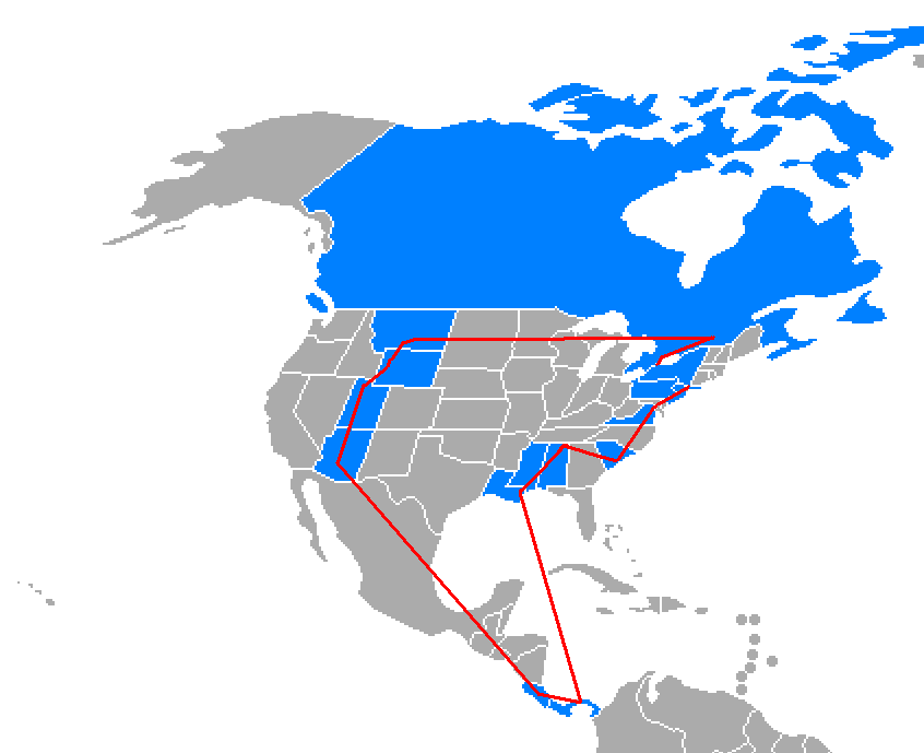
The Amazing Race 8 route map, US states and other countries visited colored in blue. (only includes places that fielded actual route markers, challenges or finish mats)
Ліцэнзіяванне

|
Дазваляецца капіяваць, распаўсюджваць і(або) мадыфікаваць гэты дакумент на ўмовах ліцэнзіі GNU FDL версіі 1.2 або навейшай, выдадзенай Фондам свабоднага праграмнага забеспячэння; без Нязменных раздзелаў, без тэкстаў Вокладак. Копія ліцэнзіі ёсць у раздзеле GNU Free Documentation License.http://www.gnu.org/copyleft/fdl.htmlGFDLGNU Free Documentation Licensetruetrue |
| Гэты файл даступны па ліцэнзіі Creative Commons Пазначэнне аўтарства - На тых самых умовах 3.0 Непартаваная | ||
| ||
| Гэтая картка дададзеная ў якасці часткі абнаўлення ліцэнзіі GFDL.http://creativecommons.org/licenses/by-sa/3.0/CC BY-SA 3.0Creative Commons Attribution-Share Alike 3.0truetrue |
Назвы
Апішыце ў адным радку, што ўяўляе сабой гэты файл
Элементы, адлюстраваныя на гэтым файле
адлюстроўвае
image/png
Гісторыя файла
Націснуць на даце з часам, каб паказаць файл, якім ён тады быў.
| Дата і час | Драбніца | Памеры | Удзельнік | Тлумачэнне | |
|---|---|---|---|---|---|
| актуальн. | 07:01, 22 студзеня 2007 | | 846 × 689 (27 KB) | Roke~commonswiki | |
| 13:28, 1 мая 2006 |  | 846 × 689 (27 KB) | Roke~commonswiki | +s.carolina | |
| 07:46, 1 мая 2006 |  | 846 × 689 (27 KB) | Roke~commonswiki | The Amazing Race 8 route map, US states and other countries visited colored in blue. (only includes places that fielded actual route markers, challenges or finish mats) Category: TV world maps |
Выкарыстанне файла
Няма старонак, якія выкарыстоўваюць гэты файл.
Глабальнае выкарыстанне файла
Гэты файл выкарыстоўваецца ў наступных вікі:
- Выкарыстанне ў en.wikipedia.org
- Выкарыстанне ў es.wikipedia.org
- Выкарыстанне ў fr.wikipedia.org
- Выкарыстанне ў id.wikipedia.org
- Выкарыстанне ў it.wikipedia.org
- Выкарыстанне ў no.wikipedia.org
- Выкарыстанне ў pl.wikipedia.org
- Выкарыстанне ў th.wikipedia.org
- Выкарыстанне ў zh.wikipedia.org