File:SCO_Map.png
From Wikipedia, the free encyclopedia
SCO_Map.png (600 × 600 na pixel, pakadakula: 139 KB, tipo nin MIME: image/png)
An sagunson na ini naggikan sa Wikimedia Commons asin mapuwedeng gamiton kan ibang mga proyekto. Pinapahiling tabi sa ibaba an deskripsyon na yaon sa sagunsong deskripsyon kan pahina.
Hali sa Wikimedia Commons an file na ito asin pwedeng magamit sa ibang proyekto. Mahihiling sa baba an paglaladawan sa pahina kan paglaladawan kan file kaini duman.

|
File:SCO (orthographic projection).svg is a vector version of this file. It should be used in place of this PNG file when not inferior.
File:SCO Map.png → File:SCO (orthographic projection).svg
For more information, see Help:SVG.
|
.svg) |
| PagladawanSCO Map.png |
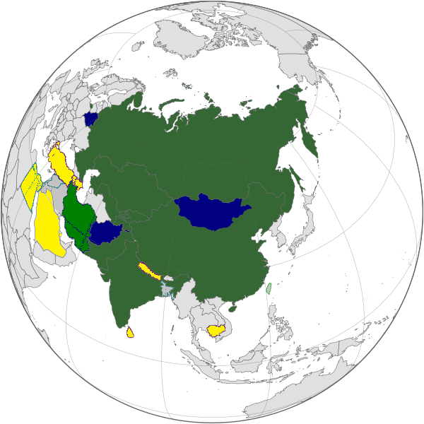
English: Map of the Shanghai Cooperation Organization.
Русский: Карта Шанхайской Организации Сотрудничества. |
||||||||
| Petsa | 12 Abril 2005, updated on 20 June 2009 | ||||||||
| Pinagkunan | |||||||||
| Kagsurat | Aris Katsaris, updated by Emilfaro | ||||||||
| Pagtugot (Giraray na paggamit sa file) |
|

Captions
Items portrayed in this file
depicts English
copyright status English
copyrighted English
inception English
12 Abril 2005
Kasaysayan kan file
Pinduton an sarong petsa/oras para mahiling ng file sa puntong idto.
| Petsa/Oras | Thumbnail | Sukol | Paragamit | Komento | |
|---|---|---|---|---|---|
| presente | 07:22, 20 Setyembre 2022 | | 600 × 600 (139 KB) | Yuri V. | correct version, without errors |
| 11:07, 18 Setyembre 2017 |  | 600 × 600 (173 KB) | Hwatas | India and Pakistan | |
| 03:28, 20 Hunyo 2009 |  | 1,200 × 1,200 (367 KB) | Emilfaro | Orthographic projection. | |
| 12:48, 16 Hunyo 2009 |  | 1,567 × 692 (177 KB) | Honmingjun | Change the color of Taiwan | |
| 11:41, 8 Pebrero 2009 |  | 1,567 × 692 (218 KB) | Emilfaro | Based on SVG. | |
| 06:25, 25 Oktubre 2008 |  | 1,425 × 625 (34 KB) | KAVO | {{Information |Description= |Source= |Date= |Author= |Permission= |other_versions= }} | |
| 12:37, 22 Oktubre 2008 |  | 1,425 × 625 (58 KB) | Emilfaro | Turkmenistan color changed. | |
| 12:35, 22 Oktubre 2008 |  | 1,425 × 625 (31 KB) | Emilfaro | Sorry, Turkmenistan is still CIS, thus a Guest Attendance. | |
| 18:39, 18 Oktubre 2008 |  | 1,425 × 625 (31 KB) | Emilfaro | Turkmenistan was included by mistake. | |
| 18:15, 18 Oktubre 2008 |  | 1,425 × 625 (31 KB) | Emilfaro | Global map as the alliance is large. |
Paggamit sa file
Mayong pahinang naggagamit sa file na ini.
Pankinaban na paggamit sa file
Ginagamit kan mga minasunod na wiki an file na ini:
- Paggamit sa da.wikipedia.org
- Paggamit sa en.wikipedia.org
- Paggamit sa es.wikipedia.org
- Paggamit sa fr.wikinews.org
- Paggamit sa simple.wikipedia.org
- Paggamit sa zh.wikipedia.org
Metadatos
Igwa nin dagdag na impormasyon an file na ini, baad hali sa kamera o scanner na ginamit para gibuhon o ma-digitize ini.
Kung an file nabago hali sa orihinal kaining estado, pwedeng dai na syertong tama an magkapirang nakalaaag na detalye sa nabagong file.
| Pahigdang resolusyon | 37.8 dpc |
|---|---|
| Patindog na resolusyon | 37.8 dpc |