File:Nagorno-Karabakh_Republic_(orthographic_projection)_v1.png
From Wikipedia, the free encyclopedia
Pakadakula kan pasirip na ini: 603 × 599 na pixel. Ibang mga resolusyon: 242 × 240 na pixel | 617 × 613 na pixel.
Orihinal na file (617 × 613 na pixel, pakadakula: 120 KB, tipo nin MIME: image/png)
An sagunson na ini naggikan sa Wikimedia Commons asin mapuwedeng gamiton kan ibang mga proyekto. Pinapahiling tabi sa ibaba an deskripsyon na yaon sa sagunsong deskripsyon kan pahina.
Hali sa Wikimedia Commons an file na ito asin pwedeng magamit sa ibang proyekto. Mahihiling sa baba an paglaladawan sa pahina kan paglaladawan kan file kaini duman.
| PagladawanRepublic of Artsakh (orthographic projection) v1.png |
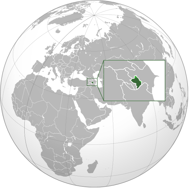
English: Orthographic Projection Map of the Nagorno-Karabakh Republic Dark Green represents areas under ethnic Armenian military control, light green represents areas claimed by the republic, under Azerbaijan government control. |
| Petsa | (UTC) |
| Pinagkunan | |
| Kagsurat |
|
.svg)
| This is a retouched picture, which means that it has been digitally altered from its original version. Modifications: made the location of NKR more clear on the world map. The original can be viewed here: Nagorno-Karabakh Republic (orthographic projection).svg:
|
| Public domainPublic domainfalsefalse |
| This work is ineligible for copyright and therefore in the public domain because it consists entirely of information that is common property and contains no original authorship. |
Original upload log
This image is a derivative work of the following images:
- File:Nagorno-Karabakh_Republic_(orthographic_projection).svg licensed with PD-ineligible
- 2010-02-23T00:53:47Z Kentronhayastan 550x550 (594491 Bytes) cleaned up the fixed borders
- 2010-02-21T11:04:39Z Dinamik 550x550 (655950 Bytes) some more information about territory
- 2010-02-12T12:42:58Z Justass 550x550 (586396 Bytes) Reverted to version as of 10:24, 27 January 2010
- 2010-02-12T12:40:31Z Maulucioni 550x550 (105958 Bytes) to png
- 2010-01-27T10:24:54Z Kentronhayastan 550x550 (586396 Bytes) adjusted map size
- 2010-01-27T10:19:16Z Kentronhayastan 550x550 (586344 Bytes) {{Information |Description={{en|1=Orthographic Projection Map of the Nagorno-Karabakh Republic}} |Source=Ssolbergj's work |Author=kentronhayastan, Ssolbergj |Date= |Permission= |other_versions= }}
Uploaded with derivativeFX
Captions
Add a one-line explanation of what this file represents
Items portrayed in this file
depicts English
inception English
11 Enero 2011
Kasaysayan kan file
Pinduton an sarong petsa/oras para mahiling ng file sa puntong idto.
| Petsa/Oras | Thumbnail | Sukol | Paragamit | Komento | |
|---|---|---|---|---|---|
| presente | 18:46, 11 Enero 2011 | | 617 × 613 (120 KB) | Ashot Arzumanyan | {{Information |Description={{en|1=Orthographic Projection Map of the Nagorno-Karabakh Republic}} Dark Green represents areas under ethnic Armenian military control, light green represents areas claimed by the republic, under Azerbaijan government control. |
Paggamit sa file
Mayong pahinang naggagamit sa file na ini.
Pankinaban na paggamit sa file
Ginagamit kan mga minasunod na wiki an file na ini:
- Paggamit sa en.wikipedia.org
- Paggamit sa fa.wikipedia.org
- Paggamit sa hy.wikipedia.org
_v1.png)