File:BlankMap-World-1970.png
From Wikipedia, the free encyclopedia
Orihinal na file (1,357 × 628 na pixel, pakadakula: 48 KB, tipo nin MIME: image/png)
An sagunson na ini naggikan sa Wikimedia Commons asin mapuwedeng gamiton kan ibang mga proyekto. Pinapahiling tabi sa ibaba an deskripsyon na yaon sa sagunsong deskripsyon kan pahina.
Hali sa Wikimedia Commons an file na ito asin pwedeng magamit sa ibang proyekto. Mahihiling sa baba an paglaladawan sa pahina kan paglaladawan kan file kaini duman.

|
This locator map image could be re-created using vector graphics as an SVG file. This has several advantages; see Commons:Media for cleanup for more information. If an SVG form of this image is available, please upload it and afterwards replace this template with
{{vector version available|new image name}}.
It is recommended to name the SVG file “BlankMap-World-1970.svg”—then the template Vector version available (or Vva) does not need the new image name parameter. |
Sumaryo
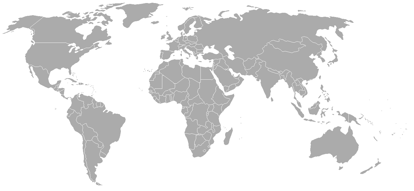
Map of the world with 1970 borders. Differences with 1985 map include: Portuguese Timor separate from Indonesia, Sikkim independent from India, North and South Vietnam separate, Walvis Bay not part of South West Africa.
Should be accurate for the period between January 4, 1969 (Spain hands over Ifni to Morocco), December 18, 1969 (Saudi-Kuwaiti neutral zone partioned between Kuwait and Saudi Arabia), and May 16, 1975 (Sikkim becomes part of India). Further information see: List of national border changes since World War I
| Blank maps of the world for historical use | |
| pre-1800 | |
|
19th century | |
|
20th century | |
|
1902 · 1912 · 1914 · WWI · Aug 1918 · 1920 · 1921 · 1924 · 1926 · 1935 · 1937 · Mar 1938 · Oct 1938 · Mar 1939 · Oct 1939 · WWII · Nov 1942 · May 1945 · 1957 · 1959 · 1962 · 1968 · 1970 · 1985 · 1990 · 1993 | |
|
21st century | |
| (this template: · view · discuss ) | |
.PNG)
Paglisensya

|
Tinutugutan an pagkopya, pagpanao, asin/o pagbago sa dokumentong ini sa irarom kan mga termino kan GNU Free Documentation License, Bersyon 1.2 o dawa anong mas bagong bersyon na naipublikar kan Free Software Foundation; na mayong paburubagong seksyon, mayong teksto sa front-cover, asin walang teksto sa back-cover. Igwang nakalaag na kopya kan lisensya sa seksyon na may titulong GNU Free Documentation License.http://www.gnu.org/copyleft/fdl.htmlGFDLGNU Free Documentation Licensetruetrue |
| Nakalisensya an file na ini sa irarom kan lisensyang Creative Commons Attribution-Share Alike 3.0 Unported. | ||
| ||
| This licensing tag was added to this file as part of the GFDL licensing update.http://creativecommons.org/licenses/by-sa/3.0/CC BY-SA 3.0Creative Commons Attribution-Share Alike 3.0truetrue |
| Annotations InfoField | This image is annotated: View the annotations at Commons |
Conflict between Argentina - United Kingdom in Falkland Islands / Islas Malvinas.
Captions
Items portrayed in this file
depicts English
copyright status English
copyrighted English
media type English
image/png
checksum English
79542df6ee3ef9c534436c48f8cbfe608b37a91a
data size English
49,148 byte
height English
628 pixel
width English
1,357 pixel
Kasaysayan kan file
Pinduton an sarong petsa/oras para mahiling ng file sa puntong idto.
| Petsa/Oras | Thumbnail | Sukol | Paragamit | Komento | |
|---|---|---|---|---|---|
| presente | 02:50, 24 Setyembre 2007 | | 1,357 × 628 (48 KB) | Hoshie | put the (N/S) Yemen boundary in white due to the fact the boundaries in southern Saudi Arabia have been disputed, undemarcated, or undisclosed over the years. |
| 01:22, 6 Agosto 2007 |  | 1,357 × 628 (48 KB) | Hoshie | added Cabinda, under same lic. as orginal. | |
| 02:59, 29 Enero 2007 |  | 1,357 × 628 (48 KB) | Hoshie | added the Canal Zone | |
| 10:29, 28 Enero 2007 |  | 1,357 × 628 (48 KB) | Hoshie | Saudi Arabia-Yemen boundry did not exist during this time. | |
| 09:02, 5 Enero 2007 |  | 1,357 × 628 (48 KB) | Roke~commonswiki | Blank map of the world in 1970. Differences with 1985 map include: Portugese Timor separate from Indonesia, Sikkim independent from India, North and South Vietnam separate, Walvis Bay not part of South Africa. [[Categor |
Paggamit sa file
Mayong pahinang naggagamit sa file na ini.
Pankinaban na paggamit sa file
Ginagamit kan mga minasunod na wiki an file na ini:
- Paggamit sa ca.wikipedia.org
- Paggamit sa de.wikipedia.org
- Paggamit sa es.wikipedia.org
- Paggamit sa fr.wikipedia.org
- Paggamit sa nl.wikipedia.org
- Paggamit sa zh.wikipedia.org