File:Mapa_Geografico_de_America_Meridional_(1790).jpg
From Wikipedia, the free encyclopedia
Orihinal na file (1,059 × 1,497 na pixel, pakadakula: 558 KB, tipo nin MIME: image/jpeg)
An sagunson na ini naggikan sa Wikimedia Commons asin mapuwedeng gamiton kan ibang mga proyekto. Pinapahiling tabi sa ibaba an deskripsyon na yaon sa sagunsong deskripsyon kan pahina.
Hali sa Wikimedia Commons an file na ito asin pwedeng magamit sa ibang proyekto. Mahihiling sa baba an paglaladawan sa pahina kan paglaladawan kan file kaini duman.
Sumaryo
| PagladawanMapa Geografico de America Meridional (1790).jpg |
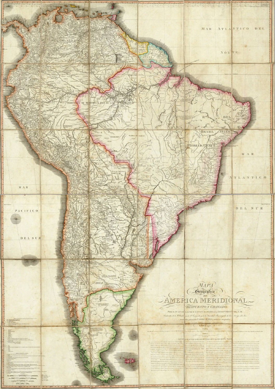
English: Geographical Map of South America, Drawn and Engraved by Mr. Juan de la Cruz Cano y Olmedilla, Geographer to His Majesty...
Español: Mapa Geografico de America Meridional, dispuesto y gravado por D. Juan de la Cruz Cano y Olmedilla, Geogfo. Pensdo. de S. M. Individuo de la R. Academia de Sn. Fernando, y da la Sociedad Bascongada de los Amigos del Pais, teniendo presentes Varios Mapas y noticias originales con arreglo a Observaciones astronómicas (Año 1775.) Londres, Publicado por William Faden, Geografo del Rey, y del Principe de Gales, Enero 1 de 1799. |
||||||||||||||||||||||
| Petsa | 1775, reprinted 1799 | ||||||||||||||||||||||
| Pinagkunan | Unknown sourceUnknown source | ||||||||||||||||||||||
| Kagsurat |
creator QS:P170,Q8008902 |
||||||||||||||||||||||
| Other versions |
|
||||||||||||||||||||||
.jpg)
Paglisensya
|
This is a faithful photographic reproduction of a two-dimensional, public domain work of art. The work of art itself is in the public domain for the following reason:
The official position taken by the Wikimedia Foundation is that "faithful reproductions of two-dimensional public domain works of art are public domain".
This photographic reproduction is therefore also considered to be in the public domain in the United States. In other jurisdictions, re-use of this content may be restricted; see Reuse of PD-Art photographs for details. | |||||
Captions
Items portrayed in this file
depicts English
inception English
1790
Kasaysayan kan file
Pinduton an sarong petsa/oras para mahiling ng file sa puntong idto.
| Petsa/Oras | Thumbnail | Sukol | Paragamit | Komento | |
|---|---|---|---|---|---|
| presente | 02:37, 14 Mayo 2006 | | 1,059 × 1,497 (558 KB) | Fbaltra | |
| 02:32, 14 Mayo 2006 |  | 1,097 × 1,536 (360 KB) | Fbaltra | == Summary == Mapa Geografico de America Meridional de Juan de la Cruz Cano y Olmedilla, 1790. Publicado en 1799 por William Faden, Londres. == Licensing == {{PD-Art}} Category:Historical maps of South America Category:Historical maps of Chile |
Paggamit sa file
Mayong pahinang naggagamit sa file na ini.
Pankinaban na paggamit sa file
Ginagamit kan mga minasunod na wiki an file na ini:
- Paggamit sa de.wikipedia.org
- Paggamit sa en.wikipedia.org
- Paggamit sa es.wikipedia.org
- Paggamit sa it.wikipedia.org
- Paggamit sa roa-tara.wikipedia.org
Metadatos
Igwa nin dagdag na impormasyon an file na ini, baad hali sa kamera o scanner na ginamit para gibuhon o ma-digitize ini.
Kung an file nabago hali sa orihinal kaining estado, pwedeng dai na syertong tama an magkapirang nakalaaag na detalye sa nabagong file.
| _error | 0 |
|---|
.jpg)