File:Senatorial_and_Imperial_provinces_mid_2nd_century.png
From Wikipedia, the free encyclopedia
Gress dea Voaschau: 800 × 551 Pixel Weitere Auflésungan: 320 × 221 Pixel | 640 × 441 Pixel | 1.024 × 706 Pixel | 1.280 × 882 Pixel | 2.052 × 1.414 Pixel.
Version in hechara Auflesung (2.052 × 1.414 Pixel, Dateigress: 155 KB, MIME-Typ: image/png)
De Datei kimpt vo Wikimedia Commons. De Beschreibung vo da Dateibschreibungsseitn wead untn ozoagt.
| BschreiwungSenatorial and Imperial provinces mid 2nd century.png |
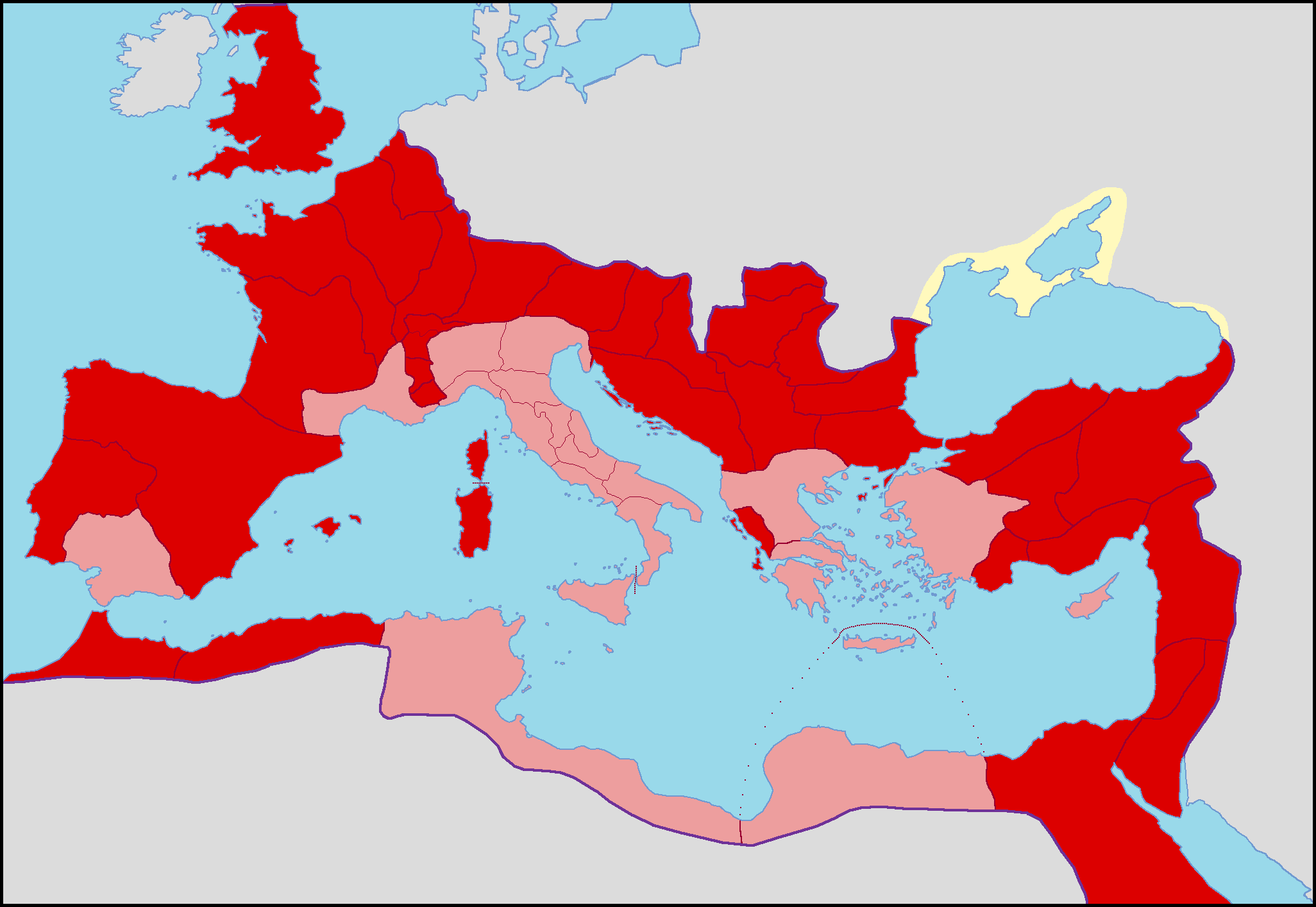
English: Map of the Roman Empire with differents colours for senatorial (pink) and imperial (red) provinces
Français : Carte de l'Empire romain sous le règne d'Antonin le Pieux avec les provinces sénatoriales et impériales de différentes couleurs.
Italiano: Carta dell'Impero Romano con colori differenti per le province senatorie (rosa) e imperiali (rosso) sotto il regno di Antonino Pio |
| Daatum | |
| Quejn | Eigenes Werk |
| Urhéwer | Coldeel (talk) 13:34, 15 March 2009 (UTC) |
| Aundre Versióner | File:Blank Roman Empire.png |
Lizenz
| Public domainPublic domainfalsefalse |
| Ich, der Urheberrechtsinhaber dieses Werkes, veröffentliche es als gemeinfrei. Dies gilt weltweit. In manchen Staaten könnte dies rechtlich nicht möglich sein. Sofern dies der Fall ist: Ich gewähre jedem das bedingungslose Recht, dieses Werk für jedweden Zweck zu nutzen, es sei denn, Bedingungen sind gesetzlich erforderlich. |
Kurzbeschreibungen
Ergänze eine einzeilige Erklärung, was diese Datei darstellt.
In dieser Datei abgebildete Objekte
Motiv Deutsch
Einige Werte ohne einen Wikidata-Eintrag
Lizenz Deutsch
Quelle der Datei Deutsch
Dateiversiona
Wensd auf an Zeitpunkt klickst, nacha konst a friaane Version lodn.
| Version vom | Vorschaubuidl | Dimensióna | Nutzer | Kommentar | |
|---|---|---|---|---|---|
| aktuell | 15:31, 15. Mer. 2009 | | 2.052 × 1.414 (155 KB) | ColdEel | Nouvelle version plus juste de l'Empire vers sous le règne d'Antonin le Pieux. |
| 19:14, 23. Few. 2009 |  | 1.600 × 1.096 (81 KB) | Mandrak | {{Information |Description=Map of the Roman Empire with differents colours for senatorial and imperial provinces |Source=*File:Romia_Imperio_sen_provinconomoj.png |Date=2009-02-23 17:13 (UTC) |Author=*File:Romia_Imperio_sen_provinconomoj.png: |
Dateivawendung
Koa Seitn nutzt de Datei.
Globale Dateinutzung
D'noochéfóiganden åndern Wikis vawénden dé Datei:
- Vawendung af ca.wikipedia.org
- Vawendung af es.wikipedia.org
- Vawendung af fr.wikipedia.org
- Vawendung af it.wikipedia.org
- Vawendung af ro.wikipedia.org