File:Europe_1878_map_de.png
From Wikipedia, the free encyclopedia
Sınaq göstərişi ölçüsü: 800 × 526 piksel. Digər ölçülər: 320 × 211 piksel | 640 × 421 piksel | 1.024 × 674 piksel | 1.280 × 842 piksel | 2.284 × 1.503 piksel.
Faylın orijinalı (2.284 × 1.503 piksel, fayl həcmi: 1,01 MB, MIME növü: image/png)
| Bu fayl "Vikimedia Commons"dadır və digər layihələrdə istifadə edilə bilər. |
 |
Faylın təsvir səhifəsinə get |
Xülasə
| İzahEurope 1878 map de.png |
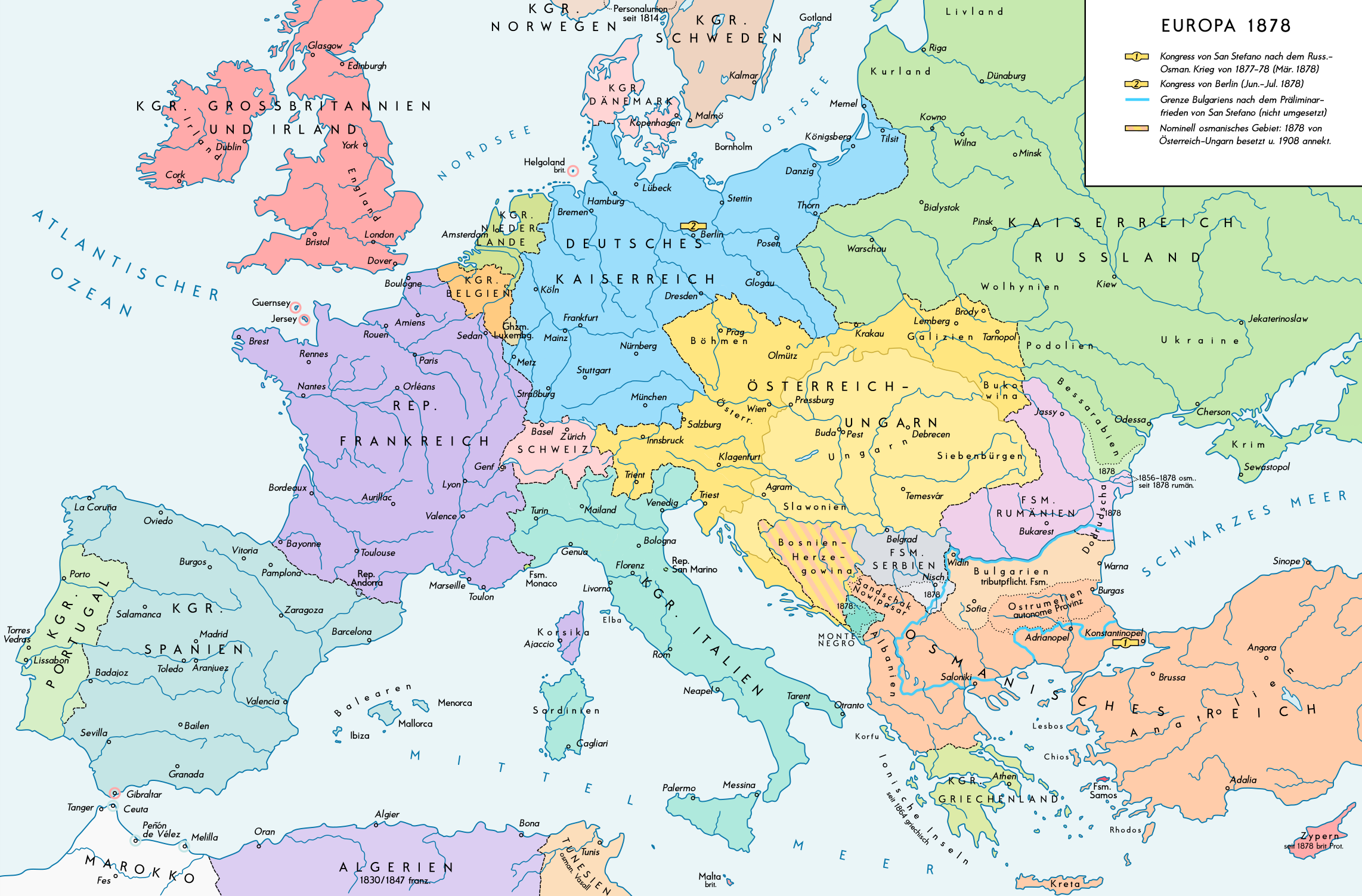
English: Europe 1878. Historical map of the political situation after the Congress of Berlin and the territorial and political rearrangement of the Balkan Peninsula. Please don't alter the map, when you think there something not written or depicted correctly. Leave a message at the talk page of the file. After a verificiation and a possible discussion, i will upload a new map version with all new changes. This prevents an unnecessary waste of disc space and ensures a good result, aesthetically and contentwise. - The author. Deutsch: Europa 1878. Historische Karte der politischen Situation nach dem Berliner Kongress und der politischen und territorialen Neuordnung des Balkans. Bitte die Karte bei Änderungs- und Korrekturwünschen nicht selbst verändern, sondern eine Anmerkung im Diskussionsbereich der Bilddatei hinterlassen. Nach einer Prüfung und ggfs. Diskussion werden evtl. Änderungen von mir zusammengefasst eingearbeitet. Das vermeidet unnötige Speicherplatz-Verschwendung und gewährleistet ein ästhetisch ansprechendes und inhaltlich korrektes Ergebnis. - Der Urheber. |
| Tarix | |
| Mənbə |
Öz işi. Source of Information: Historical atlases and maps – Ramsay Muir, George Philip (ed.): Philip's New School Atlas of Universal History, George Philip & Son, Ltd., London 1928 – Dr. Walter Leisering (ed.): Putzger Historischer Weltatlas, Cornelsen Verlag, Berlin 1992, ISBN 3-464-00176-8 – Bayerischer Schulbuch-Verlag (ed.): Großer Historischer Weltatlas, Dritter Teil, Neuzeit, Bayerischer Schulbuch-Verlag, München 1981, ISBN 3-7627-6021-7. – Prof. Dr. Vadim Oswalt u. Prof. Dr. Hans Ulrich Rudolf (ed.): Klett-Perthes Atlas zur Weltgeschichte, Ernst Klett Verlag, Stuttgart 2011, ISBN 978-3-12-828194-0 |
| Müəllif | Alexander Altenhof |
| Digər versiyalar |
|

Recompressed without quality loss with OptiPNG (1.28 MB > 1.00 MB)
Lisenziya
I, the copyright holder of this work, hereby publish it under the following license:
This file is licensed under the Creative Commons Attribution-Share Alike 4.0 International license.
- Azadsınız:
- paylaşmaq – əsəri köçürmək, paylamaq və ötürmək üçün
- remiks etmək – əsəri adaptasiya etmək
- Aşağıdakı şərtlərə riayət etməklə:
- istinad – Müvafiq kredit verməlisiniz, lisenziyaya bir keçid verməlisiniz və dəyişikliklərin olub olmadığını bildirməlisiniz. Bunu hər hansı bir ağlabatan şəkildə edə bilərsiniz, ancaq lisenziyalaşdırıcının sizi və ya istifadənizi təsdiqləməsini təklif edən bir şəkildə deyil.
- bənzər paylaşma – Əsəri remix edirsinizsə, dəyişdirirsinizsə və ya üzərində iş aparırsınızsa, öz töhfələrinizi orijinalda olduğu kimi eyni və ya uyğun lisenziya altında yayımlamalısınız.
Captions
Add a one-line explanation of what this file represents
Items portrayed in this file
təsvir edir
some value
copyright status ingilis
copyrighted ingilis
11 sentyabr 2016
source of file ingilis
original creation by uploader ingilis
media type ingilis
image/png
Faylın tarixçəsi
Faylın əvvəlki versiyasını görmək üçün gün/tarix bölməsindəki tarixlərə klikləyin.
| Tarix/Vaxt | Miniatür | Ölçülər | İstifadəçi | Şərh | |
|---|---|---|---|---|---|
| hal-hazırkı | 23:53, 14 aprel 2017 | | 2.284 × 1.503 (1,01 MB) | KaterBegemot | Minor changes |
| 22:35, 10 sentyabr 2016 |  | 2.284 × 1.503 (1.023 KB) | KaterBegemot | {{Information |Description ={{en|1=Europe 1878. Historical map of the political situation after the Congress of Berlin and the territorial and political rearrangement of the Balkan Peninsula.<br> ''Please don't alter the map, when you think there so... |
Faylın istifadəsi
Bu faylı istifadə edən səhifə yoxdur.
Faylın qlobal istifadəsi
Bu fayl aşağıdakı vikilərdə istifadə olunur:
- de.wikipedia.org layihəsində istifadəsi
- lt.wikipedia.org layihəsində istifadəsi
- lt.wikibooks.org layihəsində istifadəsi
- zh.wikipedia.org layihəsində istifadəsi
Metaməlumatlar
Bu faylda fotoaparat və ya skanerlə əlavə olunmuş məlumatlar var. Əgər fayl sonradan redaktə olunubsa, bəzi parametrlər bu şəkildə göstərilənlərdən fərqli ola bilər.
| Üfüqi xətt | 70 dpi |
|---|---|
| Şaquli xətt | 70 dpi |
| Rəng sahəsi | Fotoşəkildə rəng seçimi edilməmişdir. |
| Şəkilin eni | 2.284 px |
| Şəkilin hündürlüyü | 1.503 px |
| Proqram təminatı | Adobe Photoshop CC 2017 (Windows) |
| Tarix və vaxt rəqəmləşdirilir | 14:45, 8 aprel 2017 |
| Faylın dəyişməsi tarixi və vaxtı | 03:27, 15 aprel 2017 |
| Date metadata was last modified | 03:27, 15 aprel 2017 |
| Unique ID of original document | xmp.did:dd077bf2-bd99-fb40-8c20-266ee80cfa99 |