File:ÖRF_2011.png
From Wikipedia, the free encyclopedia
Daha yüksək versiyası yoxdur.
ÖRF_2011.png (790 × 439 piksel, fayl həcmi: 374 KB, MIME növü: image/png)
| Bu fayl "Vikimedia Commons"dadır və digər layihələrdə istifadə edilə bilər. |
 |
Faylın təsvir səhifəsinə get |
Xülasə
| İzahÖRF 2011.png |
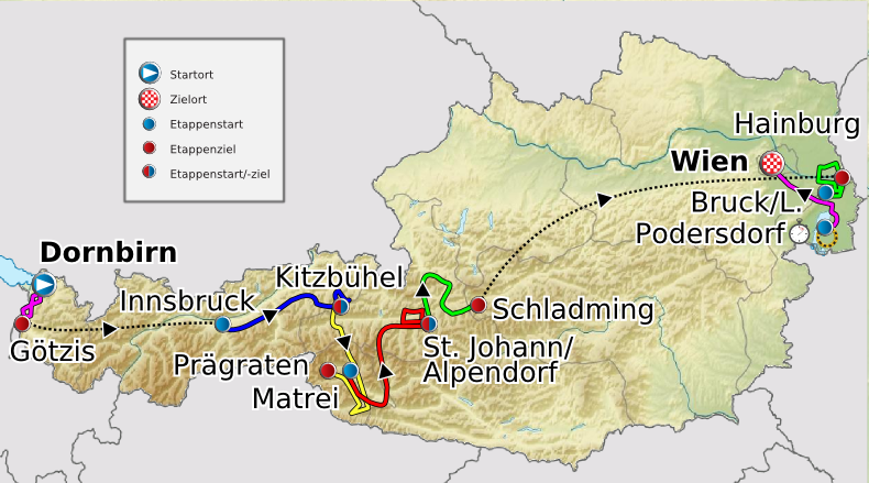
Deutsch: Verlauf der Österreich-Rundfahrt 2011
English: Route of the Tour of Austria 2011
Français : Parcours de la Tour d'Autriche 2011 |
| Tarix | 20 may 2011 (original upload date) |
| Mənbə |
Transferred from de.wikipedia to Commons. |
| Müəllif |
|
Lisenziya
I, the copyright holder of this work, hereby publish it under the following licenses:
Bu fayl Creative Commons Attribution-Share Alike 3.0 Unported lisenziyası altında yayımlanır.
- Azadsınız:
- paylaşmaq – əsəri köçürmək, paylamaq və ötürmək üçün
- remiks etmək – əsəri adaptasiya etmək
- Aşağıdakı şərtlərə riayət etməklə:
- istinad – Müvafiq kredit verməlisiniz, lisenziyaya bir keçid verməlisiniz və dəyişikliklərin olub olmadığını bildirməlisiniz. Bunu hər hansı bir ağlabatan şəkildə edə bilərsiniz, ancaq lisenziyalaşdırıcının sizi və ya istifadənizi təsdiqləməsini təklif edən bir şəkildə deyil.
- bənzər paylaşma – Əsəri remix edirsinizsə, dəyişdirirsinizsə və ya üzərində iş aparırsınızsa, öz töhfələrinizi orijinalda olduğu kimi eyni və ya uyğun lisenziya altında yayımlamalısınız.

|
Bu sənədi GNU Azad Sənədləşdirmə Lisenziyası, Versiya 1.2 və ya Azad Proqram Fondu tərəfindən nəşr olunan hər hansı sonrakı versiya şərtlərinə əsasən dəyişməz bölmələr, ön qapaq mətnləri və arxa qapaq mətnləri olmadan köçürmək, yayımlamaq və / və ya dəyişdirmək üçün icazə verilir; Lisenziyanın bir nüsxəsi GNU Azad Sənədləşdirmə Lisenziyası adlı hissəyə daxil edilmişdir.http://www.gnu.org/copyleft/fdl.htmlGFDLGNU Free Documentation Licensetruetrue |
İstədiyiniz lisenziyanı seçə bilərsiniz.
Orijinal yükləmə gündəliyi
The original description page was here. All following user names refer to de.wikipedia.
- 2011-05-23 17:12 Maxxl2 801×445× (397530 bytes) {{Information |Beschreibung = |Quelle = |Urheber = |Datum = |Genehmigung = |Andere Versionen = |Anmerkungen = Typo beseitigt }}
- 2011-05-23 12:51 Maxxl2 800×445× (397397 bytes) {{Information |Beschreibung = |Quelle = |Urheber = |Datum = |Genehmigung = |Andere Versionen = |Anmerkungen = Typo beseitigt - Auflösung verbessert }}
- 2011-05-20 21:05 Maxxl2 500×278× (180848 bytes) {{Information |Beschreibung = Verlauf der Österreich-Rundfahrt 2011 |Quelle = http://www.oesterreich-rundfahrt.at/ |Urheber = [[Maxxl2]] unter Verwendung der Karten von [[Lencer]] und [[Uwe Dedering]] |Datum = 20.05.2011
This image is a derivative work of the following images:
- File:Austria_location_map.svg licensed with Cc-by-sa-3.0, GFDL
- 2008-09-11T16:25:48Z Lencer 1256x700 (164515 Bytes) {{Information |Description= |Source= |Date= |Author= |Permission= |other_versions= }}
- 2008-09-10T15:16:19Z Lencer 1256x700 (161047 Bytes) {{Information |Description= |Source= |Date= |Author= |Permission= |other_versions= }}
- 2008-07-18T11:34:43Z NordNordWest 1256x700 (152529 Bytes) {{Information |Description= {{de|Positionskarte von [[:de:Österreich|Österreich]]}} Quadratische Plattkarte, N-S-Streckung 150 %. Geographische Begrenzung der Karte: * N: 49.2° N * S: 46.3° N * W: 9.4° O * O: 17.2
- File:Austria_relief_location_map.jpg licensed with Cc-by-sa-3.0, GFDL
- 2010-06-28T09:14:18Z Uwe Dedering 1256x700 (692901 Bytes) very little border change
- 2010-04-26T12:24:59Z Uwe Dedering 1256x700 (692757 Bytes) rhine
- 2010-04-24T12:54:54Z Uwe Dedering 1256x700 (692681 Bytes) {{Information |Description={{en|1=Location map of [[:en:Austria|Austria]]}} Equirectangular projection, N/S stretching 150 %. Geographic limits of the map: * N: 49.2° N * S: 46.3° N * W: 9.4° E * E: 17.2° E
Uploaded with derivativeFX
Captions
Add a one-line explanation of what this file represents
Items portrayed in this file
təsvir edir
copyright status ingilis
copyrighted ingilis
20 may 2011
Faylın tarixçəsi
Faylın əvvəlki versiyasını görmək üçün gün/tarix bölməsindəki tarixlərə klikləyin.
| Tarix/Vaxt | Miniatür | Ölçülər | İstifadəçi | Şərh | |
|---|---|---|---|---|---|
| hal-hazırkı | 07:59, 8 iyul 2011 | | 790 × 439 (374 KB) | MaxxL | Reverted to version as of 07:57, 8 July 2011 |
| 07:58, 8 iyul 2011 |  | 790 × 439 (374 KB) | MaxxL | Reverted to version as of 21:14, 7 July 2011 | |
| 07:57, 8 iyul 2011 |  | 790 × 439 (374 KB) | MaxxL | second effort | |
| 21:14, 7 iyul 2011 |  | 790 × 439 (374 KB) | MaxxL | upgraded track | |
| 02:15, 29 may 2011 |  | 801 × 445 (388 KB) | Saibo | 2011-05-23 17:12 Maxxl2 801×445× (397530 bytes) Typo beseitigt | |
| 02:14, 29 may 2011 |  | 800 × 445 (388 KB) | Saibo | 2011-05-23 12:51 Maxxl2 800×445× (397397 bytes) Typo beseitigt - Auflösung verbessert | |
| 02:13, 29 may 2011 |  | 500 × 278 (177 KB) | Saibo | 2011-05-20 21:05 Maxxl2 500×278× (180848 bytes) ''<nowiki>{{Information |Beschreibung = Verlauf der Österreich-Rundfahrt 2011 |Quelle = http://www.oesterreich-rundfahrt.at/ |Urheber = Maxxl2 unter Verwend |
Faylın istifadəsi
Bu faylı istifadə edən səhifə yoxdur.
Faylın qlobal istifadəsi
Bu fayl aşağıdakı vikilərdə istifadə olunur:
- de.wikipedia.org layihəsində istifadəsi
- en.wikipedia.org layihəsində istifadəsi
- es.wikipedia.org layihəsində istifadəsi
- fr.wikipedia.org layihəsində istifadəsi
- pt.wikipedia.org layihəsində istifadəsi
- ru.wikipedia.org layihəsində istifadəsi
- uk.wikipedia.org layihəsində istifadəsi