Fayl:Woking_Town_Square_-_geograph.org.uk_-_40908.jpg
From Wikipedia, the free encyclopedia
Daha yüksək versiyası yoxdur.
Woking_Town_Square_-_geograph.org.uk_-_40908.jpg (640 × 427 piksel, fayl həcmi: 85 KB, MIME növü: image/jpeg)
| Bu fayl "Vikimedia Commons"dadır və digər layihələrdə istifadə edilə bilər. |
 |
Faylın təsvir səhifəsinə get |
Xülasə
| İzahWoking Town Square - geograph.org.uk - 40908.jpg |
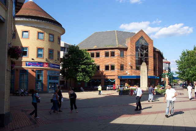
English: Woking Town Square. In 1838 when the railway arrived, Woking town centre was open heathland. The town developed in a fairly piecemeal fashion and had reached a form of completion by the mid-1980s, when redevelopment began again. A short-lived town centre swimming pool disappeared as part of those changes, to be replaced by the Pool in the Park. The present form of the town centre, including the modern library, the Peacocks shopping centre, and the refashioned Wolsey Way centre date from that time. |
| Tarix | |
| Mənbə | From geograph.org.uk |
| Müəllif | Ron Strutt |
| İstinad (required by the license) InfoField | Ron Strutt / Woking Town Square / |
InfoField | Ron Strutt / Woking Town Square |
| Object location | 51° 19′ N, 0° 34′ W | View this and other nearby images on: OpenStreetMap |
|---|
Lisenziya

|
This image was taken from the Geograph project collection. See this photograph's page on the Geograph website for the photographer's contact details. The copyright on this image is owned by Ron Strutt and is licensed for reuse under the Creative Commons Attribution-ShareAlike 2.0 license.
|
This file is licensed under the Creative Commons Attribution-Share Alike 2.0 Generic license.
İstinad: Ron Strutt
- Azadsınız:
- paylaşmaq – əsəri köçürmək, paylamaq və ötürmək üçün
- remiks etmək – əsəri adaptasiya etmək
- Aşağıdakı şərtlərə riayət etməklə:
- istinad – Müvafiq kredit verməlisiniz, lisenziyaya bir keçid verməlisiniz və dəyişikliklərin olub olmadığını bildirməlisiniz. Bunu hər hansı bir ağlabatan şəkildə edə bilərsiniz, ancaq lisenziyalaşdırıcının sizi və ya istifadənizi təsdiqləməsini təklif edən bir şəkildə deyil.
- bənzər paylaşma – Əsəri remix edirsinizsə, dəyişdirirsinizsə və ya üzərində iş aparırsınızsa, öz töhfələrinizi orijinalda olduğu kimi eyni və ya uyğun lisenziya altında yayımlamalısınız.
- Remove redundant categories and try to put this image in the most specific category/categories
- Remove this template
- The location categories are based on information from this geonames tool and this OpenStreetMap tool combined with a database. You can also have a look at this tool from mysociety.
- The topic category from Geograph was Town centre (find similar images centre at Geograph)
English | suomi | français | galego | עברית | magyar | македонски | മലയാളം | português | português do Brasil | Türkçe | +/−
Captions
Add a one-line explanation of what this file represents
Items portrayed in this file
təsvir edir
some value
copyright status ingilis
copyrighted ingilis
21 avqust 2005
coordinates of depicted place ingilis
51°19'1"N, 0°33'36"W
Faylın tarixçəsi
Faylın əvvəlki versiyasını görmək üçün gün/tarix bölməsindəki tarixlərə klikləyin.
| Tarix/Vaxt | Kiçik şəkil | Ölçülər | İstifadəçi | Şərh | |
|---|---|---|---|---|---|
| indiki | 20:29, 30 yanvar 2010 | | 640 × 427 (85 KB) | GeographBot | == {{int:filedesc}} == {{Information |description={{en|1=Woking Town Square. In 1838 when the railway arrived, Woking town centre was open heathland. The town developed in a fairly piecemeal fashion and had reached a form of completion by the mid-1980s, |
Fayl keçidləri
Aşağıdakı səhifə bu faylı istifadə edir:
Faylın qlobal istifadəsi
Bu fayl aşağıdakı vikilərdə istifadə olunur:
- af.wikipedia.org layihəsində istifadəsi
- azb.wikipedia.org layihəsində istifadəsi
- ceb.wikipedia.org layihəsində istifadəsi
- cs.wikipedia.org layihəsində istifadəsi
- en.wikipedia.org layihəsində istifadəsi
- fa.wikipedia.org layihəsində istifadəsi
- fi.wikipedia.org layihəsində istifadəsi
- hu.wikipedia.org layihəsində istifadəsi
- ja.wikipedia.org layihəsində istifadəsi
- ko.wikipedia.org layihəsində istifadəsi
- lld.wikipedia.org layihəsində istifadəsi
- nl.wikipedia.org layihəsində istifadəsi
- nn.wikipedia.org layihəsində istifadəsi
- no.wikipedia.org layihəsində istifadəsi
- pl.wikipedia.org layihəsində istifadəsi
- pl.wikivoyage.org layihəsində istifadəsi
- simple.wikipedia.org layihəsində istifadəsi
- sv.wikipedia.org layihəsində istifadəsi
- szl.wikipedia.org layihəsində istifadəsi
- ur.wikipedia.org layihəsində istifadəsi
- zh.wikipedia.org layihəsində istifadəsi
Metaməlumatlar
Bu faylda fotoaparat və ya skanerlə əlavə olunmuş məlumatlar var. Əgər fayl sonradan redaktə olunubsa, bəzi parametrlər bu şəkildə göstərilənlərdən fərqli ola bilər.
| Kamera istehsalçısı | EASTMAN KODAK COMPANY |
|---|---|
| Kamera modeli | KODAK DX4330 DIGITAL CAMERA |
| Exposure time | 1/500 saniyə (0,002) |
| F nömrəsi | f/4,8 |
| Orijinal tarix və vaxt | 16:33, 21 avqust 2005 |
| Fokus məsafəsi | 8 mm |
| Orientasiya | Normal |
| Üfüqi xətt | 230 dpi |
| Şaquli xətt | 230 dpi |
| Y və C komponetlərinə görə yerləşmə sırası | Mərkəzləşdirilmiş |
| Ekspozisiya proqramı | Normal proqram |
| Exif versiyası | 2.2 |
| Tarix və vaxt rəqəmləşdirilir | 16:33, 21 avqust 2005 |
| APEX shutter speed | 9 |
| Obyektiv gözü | 4,5 |
| APEX exposure bias | 0 |
| Maximum land aperture | 3 APEX (f/2,83) |
| Metering mode | Orta |
| İşıq mənbəsi | Naməlum |
| Flaş | Flaş yandırılmadı, compulsory flash suppression |
| Rəng sahəsi | sRGB |
| Exposure index | 120 |
| Sensing method | Birkristallı matrisli rəngli sensor |
| Custom image processing | Normal proses |
| Exposure mode | Avtomatik ekspozisiya |
| Ağ balansı | Bəyaz balansın avtomatik tənzimlənməsi |
| Digital zoom ratio | 0 |
| Focal length in 35 mm film | 38 mm |
| Scene capture type | Standart |
| Kontrast | Normal |
| Doymuşluq | Normal |
| Kəskinlik | Normal |
| Subject distance range | Naməlum |