Fayl:Near_East_1400_BCE.png
From Wikipedia, the free encyclopedia
Sınaq göstərişi ölçüsü: 750 × 600 piksel. Digər ölçülər: 300 × 240 piksel | 600 × 480 piksel | 785 × 628 piksel.
Faylın orijinalı (785 × 628 piksel, fayl həcmi: 146 KB, MIME növü: image/png)
| Bu fayl "Vikimedia Commons"dadır və digər layihələrdə istifadə edilə bilər. |
 |
Faylın təsvir səhifəsinə get |

|
This historical map image could be re-created using vector graphics as an SVG file. This has several advantages; see Commons:Media for cleanup for more information. If an SVG form of this image is available, please upload it and afterwards replace this template with
{{vector version available|new image name}}.
It is recommended to name the SVG file “Near East 1400 BCE.svg”—then the template Vector version available (or Vva) does not need the new image name parameter. |
Xülasə
| İzahNear East 1400 BCE.png |
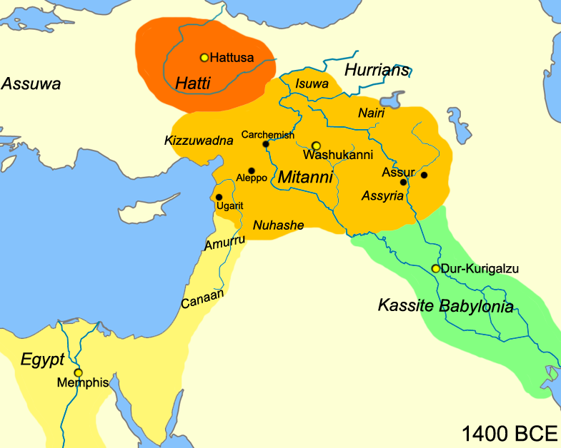
English: Map of the near east circa 1400 BCE.
עברית: מפת אזור המזרח הקרוב חלוקה לאימפריות בשנת 1400 לפנה"ס |
| Tarix | |
| Mənbə |
Öz işi
|
| Müəllif | Javierfv1212 |
| Digər versiyalar |
[redaktə]
|


Lisenziya
| Public domainPublic domainfalsefalse |
| This work has been released into the public domain by its author, Javierfv1212 at ingilis Vikipediya. This applies worldwide. In some countries this may not be legally possible; if so: Javierfv1212 grants anyone the right to use this work for any purpose, without any conditions, unless such conditions are required by law.Public domainPublic domainfalsefalse |
Orijinal yükləmə gündəliyi
The original description page was here. All following user names refer to en.wikipedia.
- 2010-03-21 22:10 Javierfv1212 785×628× (149438 bytes) {{Information |Description = Map of the near east circa 1400 BCE. |Source = I (~~~) created this work entirely by myself. Source: Cambridge Ancient History Vol II Middle East & Aegean Region 1800-1300. I. E. S. EDWARDS (Ed) et al. |Date
Captions
Add a one-line explanation of what this file represents
Items portrayed in this file
təsvir edir
21 mart 2010
Faylın tarixçəsi
Faylın əvvəlki versiyasını görmək üçün gün/tarix bölməsindəki tarixlərə klikləyin.
| Tarix/Vaxt | Miniatür | Ölçülər | İstifadəçi | Şərh | |
|---|---|---|---|---|---|
| hal-hazırkı | 15:41, 3 iyul 2010 | | 785 × 628 (146 KB) | Hanay | {{Information |Description={{en|1=Map of the near east circa 1400 BCE. }} {{he|1=מפת אזור המזרח הקרוב חלוקה לאימפריות בשנת 1400 לפנה"ס}} |Source=http://en.wikipedia.org/wiki/File:Near_East_1400_BCE.png |Author=[[Use |
Faylın istifadəsi
Faylın qlobal istifadəsi
Bu fayl aşağıdakı vikilərdə istifadə olunur:
- af.wikipedia.org layihəsində istifadəsi
- ast.wikipedia.org layihəsində istifadəsi
- azb.wikipedia.org layihəsində istifadəsi
- be-tarask.wikipedia.org layihəsində istifadəsi
- bg.wikipedia.org layihəsində istifadəsi
- bn.wikipedia.org layihəsində istifadəsi
- ca.wikipedia.org layihəsində istifadəsi
- ceb.wikipedia.org layihəsində istifadəsi
- cs.wikipedia.org layihəsində istifadəsi
- cv.wikipedia.org layihəsində istifadəsi
- da.wikipedia.org layihəsində istifadəsi
- el.wikipedia.org layihəsində istifadəsi
- en.wikipedia.org layihəsində istifadəsi
- en.wiktionary.org layihəsində istifadəsi
- et.wikipedia.org layihəsində istifadəsi
- fa.wikipedia.org layihəsində istifadəsi
- fr.wikipedia.org layihəsində istifadəsi
- he.wikipedia.org layihəsində istifadəsi
- hr.wikipedia.org layihəsində istifadəsi
- hy.wikipedia.org layihəsində istifadəsi
- hyw.wikipedia.org layihəsində istifadəsi
- incubator.wikimedia.org layihəsində istifadəsi
- it.wikipedia.org layihəsində istifadəsi
Bu faylın qlobal istifadəsinə baxın.