File:Khazarfall1.png
From Wikipedia, the free encyclopedia
Khazarfall1.png (670 × 448 píxels, tamañu de ficheru: 32 kB, triba MIME: image/png)
Esti ficheru ye de Wikimedia Commons y puen usalu otros proyeutos. La descripción de la páxina de descripción del ficheru s'amuesa darréu.
By the year of 996 Poland extended to Oder river in the north-west and well in to Bautzen (Budziszyn) in the south also included Silesia (Slask)and part of Moravia. It is observed that Gernman Wikipedia "watchers" constantly place their borders way east as to create false claims to the historic lechitic territory as their own. Please correct this falsely created map to the correct shape.
Resume
| DescripciónKhazarfall1.png |
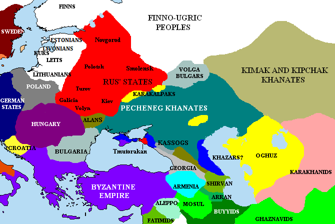
English: The Pontic steppes, c. 1015 (areas in blue possibly still under Khazar control). |
| Data | |
| Fonte | Unknown (http://en.wikipedia.org/wiki/Image:Khazarfall1.png) |
| Autor | DesconocidoUnknown author |

|
File:Khazarfall1.svg es una versión vectorial de este archivo. Debería usarse esa versión en lugar de este archivo PNG, cuando sea mejor.
File:Khazarfall1.png → File:Khazarfall1.svg
Para más información, lee Ayuda:SVG.
|
 |
Llicencia
|
NOTE: "subject to disclaimers" below may not actually apply, this was tagged with {{GFDL-user-en}}, and after May 2007, en:Template:GFDL-self did not require disclaimers. Please check the image description page on the English Wikipedia (or, if it has been deleted, ask an English Wikipedia administrator). See Wikipedia:GFDL standardization for details. | ||||||||
Briangotts na Wikipedia n'inglés, titular de los drechos d'autor d'esta obra, la espubliza baxo la siguiente llicencia:
| ||||||||
|
Note: This tag should not be used. For images that were released on the English Wikipedia using either GFDL or GFDL-self with disclaimers, use {{GFDL-user-en-with-disclaimers}}. For images without disclaimers please use {{GFDL-user-en-no-disclaimers}} instead. If you are the copyright holder of files that were released on Wikipedia, please consider removing the disclaimers. |

Pies
Elementos representados en este archivo
representa a
tipo de archivo español
image/png
20 abr 2006
Historial del ficheru
Calca nuna fecha/hora pa ver el ficheru como taba daquella.
| Data/Hora | Miniatura | Dimensiones | Usuariu | Comentariu | |
|---|---|---|---|---|---|
| actual | 00:15 30 abr 2023 | | 670 × 448 (32 kB) | Андрей Романенко | corrected (Rostov had been misplaced) |
| 19:51 24 xin 2021 |  | 670 × 448 (36 kB) | Taron Saharyan | Reverted to version as of 15:10, 27 May 2018 (UTC) | |
| 02:04 2 set 2019 |  | 670 × 448 (33 kB) | Georgiano | Reverted to version as of 12:54, 22 March 2017 (UTC) | |
| 15:10 27 may 2018 |  | 670 × 448 (36 kB) | Taron Saharyan | все армянские города, в том числе столица Ани, оказались в Грузии | |
| 12:54 22 mar 2017 |  | 670 × 448 (33 kB) | Georgiano | Reverted to version as of 08:28, 2 December 2015 (UTC) | |
| 21:25 6 xin 2017 |  | 670 × 448 (36 kB) | Calrugem | fixed caucasus | |
| 08:28 2 avi 2015 |  | 670 × 448 (33 kB) | Taron Saharyan | Reverted to version as of 10:12, 1 November 2015 (UTC) | |
| 08:23 2 avi 2015 |  | 670 × 448 (44 kB) | Taron Saharyan | коррекция границ Армении при Гагике I | |
| 10:12 1 pay 2015 |  | 670 × 448 (33 kB) | Skylight 555 | . | |
| 10:02 1 pay 2015 |  | 1000 × 671 (294 kB) | Skylight 555 | Карта территории Печенегов и прилегающих государств. |
Usu del ficheru
Nun hai páxines qu'usen esti ficheru.
Usu global del ficheru
Estes otres wikis usen esti ficheru:
- Usu en als.wikipedia.org
- Usu en an.wikipedia.org
- Usu en ar.wikipedia.org
- Usu en azb.wikipedia.org
- Usu en bar.wikipedia.org
- Usu en bg.wikipedia.org
- Usu en bn.wikipedia.org
- Usu en cs.wikipedia.org
- Usu en da.wikipedia.org
- Usu en de.wikipedia.org
- Usu en el.wikipedia.org
- Usu en en.wikipedia.org
- Khazars
- High Middle Ages
- Pechenegs
- Crimean Khanate
- Georgius Tzul
- Turkic migration
- User:Briangotts/maps
- Talk:Kievan Rus'/Kievan Rus' v Rus
- User:Kazkaskazkasako/Books/History
- Wikipedia talk:WikiProject Ukraine/Archive 4
- User:Chickstarr404/Gather lists/18093 – "The Spring of the Ram"
- History of the western steppe
- History of the central steppe
- User:WildFields/sandbox
- User:Falcaorib/Russia and Soviet Union
- User:Falcaorib/Ukraine
- User:Falcaorib/Medieval Empires (1000-1100 AD)
- User:Falcaorib/Poland-Lithuania
- User:Falcaorib/Turkey and Ottoman Empire
- Usu en eo.wikipedia.org
- Usu en es.wikipedia.org
- Usu en et.wikipedia.org
- Usu en eu.wikipedia.org
- Usu en fi.wikipedia.org
- Usu en fr.wikipedia.org
- Usu en he.wikipedia.org
Ver más usos globales d'esti ficheru.
Metadatos
Esti ficheru contien otra información, probablemente añadida pola cámara dixital o l'escáner usaos pa crealu o dixitalizalu.
Si'l ficheru se camudó dende'l so estáu orixinal, seique dalgunos detalles nun se reflexen completamente nel ficheru camudáu.
| Resolución horizontal | 37,8 ppc |
|---|---|
| Resolución vertical | 37,8 ppc |