File:Italy_1494_AD-it.svg
From Wikipedia, the free encyclopedia

Ficheru orixinal (ficheru SVG, 688 × 930 píxels nominales, tamañu de ficheru: 418 kB)
Esti ficheru ye de Wikimedia Commons y puen usalu otros proyeutos. La descripción de la páxina de descripción del ficheru s'amuesa darréu.
The factual accuracy of este mapa or the file name is disputed.
Reason: This map and its derivatives need correction and update, as it is mostly based on the Shepherd's map which shows innacurate history of Venetian Republic on Eastern Adriatic, specifically of Dalmatia. It is showing seriouly erroneous and misleading Venetian control over whole region of modern Dalmatia - which became in full extent only in the late 17th and 18th century. It was never the case in the 15th and 16th century, as then most part of Dalmatian hinterland was under Hungarian-Croatian Kingdom and then Ottoman Empire. Venetian Dalmatia at the time included only the very coastal part of Dalmatia with very near hinterland of the Dalmatian city-states, the majority of the hinterland was not Venetian at all. The borders of the Ottoman conquest are also significantly erroneous for the time period as in the map look like modern borders of Bosnia and Herzegovina which became the case only many centuries later. |  |
Resume
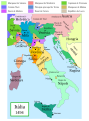
Political map of Italy in early 1494, before the invasion of Italy by Charles VIII of France, created by MapMaster.
This is a companion map to Image:Italy 1000 AD.svg, Image:Italy 1796.png, and Image:Italy c 1810.png.
Este mapa se ha mejorado o creado por wikigrafistas del Taller Gráfico (it). Puedes proponer imágenes o mapas para su creación, mejora o traducción. |
Esti ficheru SVG tien testu integráu que pue traducise fácilmente a la to llingua usando un editor de SVG como Inkscape o Adobe Illustrator. Ver más. Tamién pues descargalu y traducilu de mou manual usando un editor de testu. |
Versions
[editar]
PNG:
-
 árabe
árabe -
 inglés
 -
 griegu


SVG:
-
 catalán
 -
 español
 -
 francés
 -
 italianu
 -
 húngaru


See similar versions (disputed too): Map of Italy (1494)
References
- Bjorklund, Oddvar; Holmboe, Haakon; Rohr, Anders (1970) Historical Atlas of the World, Barnes & Noble, NY, SBN: 389-00253-4.
- Matthew, Donald, (1983), Atlas of Medieval Europe, Checkmark Books, New York.
- Online maps, including this 1882 map from Shepherd (the University of Texas)
- this one from A B Longman, textbook publisher.
Llicencia

|
Autorízase la copia, distribución y/o cambéu d'esti documentu baxo los términos de la Llicencia de documentación llibre GNU, versión 1.2 o cualesquier otra que nel futuru espublice la Free Software Foundation; ensin seiciones invariables, testos de portada, nin testos de contraportada. S'inclúi una copia de la llicencia na seición titulada GNU Free Documentation License.http://www.gnu.org/copyleft/fdl.htmlGFDLGNU Free Documentation Licensetruetrue |
| Esti ficheru ta disponible baxo la llicencia Creative Commons Reconocimientu-Compartir igual 3.0 xenérica. | ||
| ||
| Esta etiqueta de llicencia s'amestó a esti ficheru como parte del anovamientu de la llicencia GFDL.http://creativecommons.org/licenses/by-sa/3.0/CC BY-SA 3.0Creative Commons Attribution-Share Alike 3.0truetrue |
- Ye llibre:
- pa compartir – pa copiar, distribuir y comunicar públicamente la obra
- pa remezclar – p'adautar la obra
- Baxo les condiciones siguientes:
- reconocimientu – Tienes de dar el créitu apropiáu, apurrir un enllaz a la llicencia ya indicar si realizasti dalgún cambéu. Puedes faelo de cualquier mou razonable ,pero non de manera que suxera l'encontu del autor pa ti o pal usu que faigas.
- compartir igual – Si entemeces, tresformes o te bases nesti material, tienes de distribuir les tos contribuciones baxo la mesma llicencia o una compatible cola orixinal.
derivative works
Derivative works of this file: Italy 1494 AD-fr.svg
Pies
Elementos representados en este archivo
representa a
Historial del ficheru
Calca nuna fecha/hora pa ver el ficheru como taba daquella.
| Data/Hora | Miniatura | Dimensiones | Usuariu | Comentariu | |
|---|---|---|---|---|---|
| actual | 18:27 28 xun 2013 | | 688 × 930 (418 kB) | Fulvio314 | Legenda, added small territories |
| 20:46 26 may 2013 |  | 576 × 812 (417 kB) | Fulvio314 | Font | |
| 15:31 27 feb 2007 |  | 567 × 812 (1,17 MB) | MapMaster | Some modifications based on feedback from User:Paolo da Reggio | |
| 03:31 23 feb 2007 |  | 567 × 812 (1,17 MB) | MapMaster | Italia, 1494. |
Usu del ficheru
La páxina siguiente usa esti ficheru:
Usu global del ficheru
Estes otres wikis usen esti ficheru:
- Usu en ar.wikipedia.org
- Usu en bg.wikipedia.org
- Usu en br.wikipedia.org
- Usu en el.wikipedia.org
- Usu en en.wikipedia.org
- Usu en eo.wikipedia.org
- Usu en eu.wikipedia.org
- Usu en fi.wikipedia.org
- Usu en fr.wikipedia.org
- Usu en hu.wikipedia.org
- Usu en it.wikipedia.org
- Usu en it.wikiquote.org
- Usu en ja.wikipedia.org
- Usu en ko.wikipedia.org
- Usu en la.wikipedia.org
- Usu en nn.wikipedia.org
- Usu en ru.wikipedia.org
- Usu en uk.wikipedia.org
- Usu en www.wikidata.org
- Usu en zh.wikipedia.org
Metadatos
Esti ficheru contien otra información, probablemente añadida pola cámara dixital o l'escáner usaos pa crealu o dixitalizalu.
Si'l ficheru se camudó dende'l so estáu orixinal, seique dalgunos detalles nun se reflexen completamente nel ficheru camudáu.
| Anchor | 688.25183 |
|---|---|
| Altor | 929.9646 |