File:United_States_1803-04-1804-03.png
From Wikipedia, the free encyclopedia
حجم البروفه دى: 800 × 542 بكسل. الأبعاد التانيه: 320 × 217 بكسل | 640 × 433 بكسل | 1,000 × 677 بكسل.
الصوره الاصليه (1,000 × 677 بكسل حجم الفايل: 103 كيلوبايت، نوع MIME: image/png)
الملف دا من ويكيميديا كومنز و ممكن تستعمله المشاريع التانيه. الوصف بتاعه صفحة وصف الملف هناك معروض تحت..

|
هذه historical map الصورة / الصورتان باستعمال رسومات متجهية ملفات رسوميات شعاعية.
It is recommended to name the SVG file "United States 1803-04-1804-03.svg" - then the template Vector version available (or Vva) does not need the new image name parameter.
|
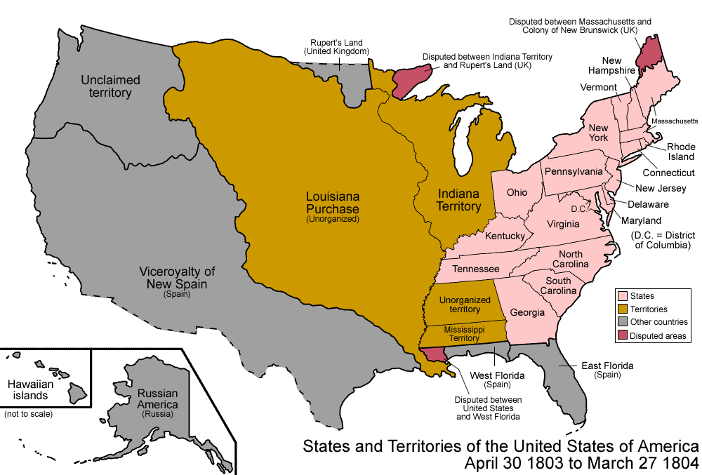
| وصفUnited States 1803-04-1804-03.png | Map of the states and territories of the United States as it was from April 1803 to March 1804. On April 30 1803, Louisiana was purchased from France, and a dispute arose if it included a portion of West Florida. On March 27 1804, the lands previously ceded by Georgia were added to Mississippi Territory. |
| مصدر | عمل شخصى |
| مؤلف | Made by User:Golbez. |
| سماح (إعادة استخدام الملف ده) |
Own work, attribution required (Multi-license with GFDL and Creative Commons CC-BY 2.5) |
أنا، صاحب حقوق التأليف والنشر لهذا العمل، أنشر هذا العمل تحت الرخص التالية:

|
يسمح بنسخ و توزيع و / أو تعديل الوثيقه دى تحت شروط رخصة جنو للوثائق الحره، الإصدار 1.2 أو أى إصدار تنشره مؤسسة البرمجيات الحره؛ بدون أقسام ثابته و بدون نصوص أغلفه أماميه و بدون نصوص أغلفه خلفيه. نسخه من الرخصه متضمنه ف قسم اسمه GNU Free Documentation License.http://www.gnu.org/copyleft/fdl.htmlGFDLGNU Free Documentation Licensetruetrue |
| الملف ده مترخص حسب رخصة المشاع الإبداعى نسبة المصنف للى مألفه - المشاركة بالمثل 3.0 العامه | ||
| ||
| تمت إضافة علامة الترخيص لهذا الملف كجزء من رخصة جنو للوثائق الحرة تحديث الترخيص.http://creativecommons.org/licenses/by-sa/3.0/CC BY-SA 3.0Creative Commons Attribution-Share Alike 3.0truetrue |
هذا الملف مُرخص تحت رخصة المشاع المبدع نسبة المصنف إلى مؤلفه 2.5 العامة
- إنت حر:
- فى المشاركه – علشان نسخ و توزيع و بث العمل
- إنك تمزج – فى تكييف العمل
- بالشروط دى:
- نسبه ل – لازم يتنسب العمل للى مألفه بشكل مناسب و توفير رابط للرخصه وتحديد اذا حصلت تغييرات. ممكن ده يتعمل بأى طريقه معقوله، لكن مش بطريقه تشير ان مانح الرخصه بيوافقك على الاستعمال.
اختار الرخصه اللى تناسبك.
| Territorial evolution maps of the United States |
| v · d (template shows date of beginning of change yyyy-mm-dd) |
| 1789-03, 1789-08, 1790-04, 1790-05, 1791-03, 1791-09, 1792-03, 1792-06, 1795, 1796, 1798, 1800-07-04, 1800-07, 1802, 1803-03, 1803-04, 1804-03, 1804-10, 1805-01, 1805-07, 1809, 1810-04, 1810-10, 1812-04, 1812-05, 1812-06, 1816, 1817-03, 1817-12, 1818-10, 1818-12, 1819-03, 1819-12, 1820, 1821-07, 1821, 1822, 1824, 1828, 1834, 1836-03, 1836-06, 1836-07, 1837-01, 1837-03, 1838, 1842, 1845-03, 1845-12, 1846-06, 1846-12, 1848-02, 1848-05, 1848-08, 1849, 1850, 1853-03, 1853-12, 1854, 1858, 1859, 1860, 1861-01, 1861-02-04, 1861-02-28, 1861-03, 1861-08, 1862, 1863-02, 1863-03, 1863-06, 1864-05, 1864-10, 1865, 1866, 1867-01, 1867-03, 1867-10, 1868, 1876, 1884, 1889-11-02, 1889-11-08, 1889-11-11, 1890-05, 1890-07-03, 1890-07-10, 1896-01, 1896-05, 1898, 1907, 1912-01, 1912-02, 1912-08, 1959-01, 1959-08 |
الشروحات
أضف شرحاً من سطر واحد لما يُمثِّله هذا الملف
العناصر المصورة في هذا الملف
يُصوِّر العربية
مصدر الملف العربية
إنشاء أصيل للرافع العربية
تاريخ الفايل
اضغط على الساعه/التاريخ علشان تشوف الفايل زى ما كان فى الوقت ده.
| الساعه / التاريخ | صورة صغيرة | ابعاد | يوزر | تعليق | |
|---|---|---|---|---|---|
| دلوقتي | 07:03، 29 يوليه 2006 | | 1,000 × 677 (103 كيلوبايت) | Golbez | {{Information| |Description=Map of the states and territories of the United States as it was from |Source= |Date= |Author=Made by User:Golbez. |Permission=Own work, attribution required (Multi-license with GFDL and Creative Commons CC-BY 2.5) |other_ |
استخدام الفايل
مافيش صفحات بتوصل للفايل ده.
استخدام الملف العام
الويكيات التانيه دى بتستخدم الفايل ده:
- الاستخدام ف als.wikipedia.org
- الاستخدام ف bar.wikipedia.org
- الاستخدام ف bg.wikipedia.org
- الاستخدام ف ca.wikipedia.org
- الاستخدام ف de.wikipedia.org
- الاستخدام ف en.wikipedia.org
- Gulf Coast of the United States
- Timeline of the history of the United States (1790–1819)
- History of North Dakota
- User:Buaidh/Territorial evolution of Colorado
- List of territorial claims and designations in Colorado
- Territorial evolution of New Mexico
- Outline of Wyoming territorial evolution
- Territorial evolution of Montana
- Outline of North Dakota territorial evolution
- Territorial evolution of South Dakota
- User:Falcaorib/Canada, United States and Mexico
- الاستخدام ف fi.wikipedia.org
- الاستخدام ف fr.wikipedia.org
- الاستخدام ف he.wikipedia.org
- الاستخدام ف hr.wikipedia.org
- الاستخدام ف ja.wikipedia.org
- الاستخدام ف no.wikipedia.org
- الاستخدام ف ro.wikipedia.org
- الاستخدام ف ru.wikipedia.org
- الاستخدام ف sh.wikipedia.org
- الاستخدام ف sr.wikipedia.org
- الاستخدام ف ta.wikipedia.org
- الاستخدام ف vi.wikipedia.org
- الاستخدام ف zh.wikipedia.org