File:BlankMap-World-1962.png
From Wikipedia, the free encyclopedia
الصوره الاصليه (1,357 × 628 بكسل حجم الفايل: 48 كيلوبايت، نوع MIME: image/png)
الملف دا من ويكيميديا كومنز و ممكن تستعمله المشاريع التانيه. الوصف بتاعه صفحة وصف الملف هناك معروض تحت..

|
هذه locator map الصورة / الصورتان باستعمال رسومات متجهية ملفات رسوميات شعاعية.
It is recommended to name the SVG file "BlankMap-World-1962.svg" - then the template Vector version available (or Vva) does not need the new image name parameter.
|
الخلاصة
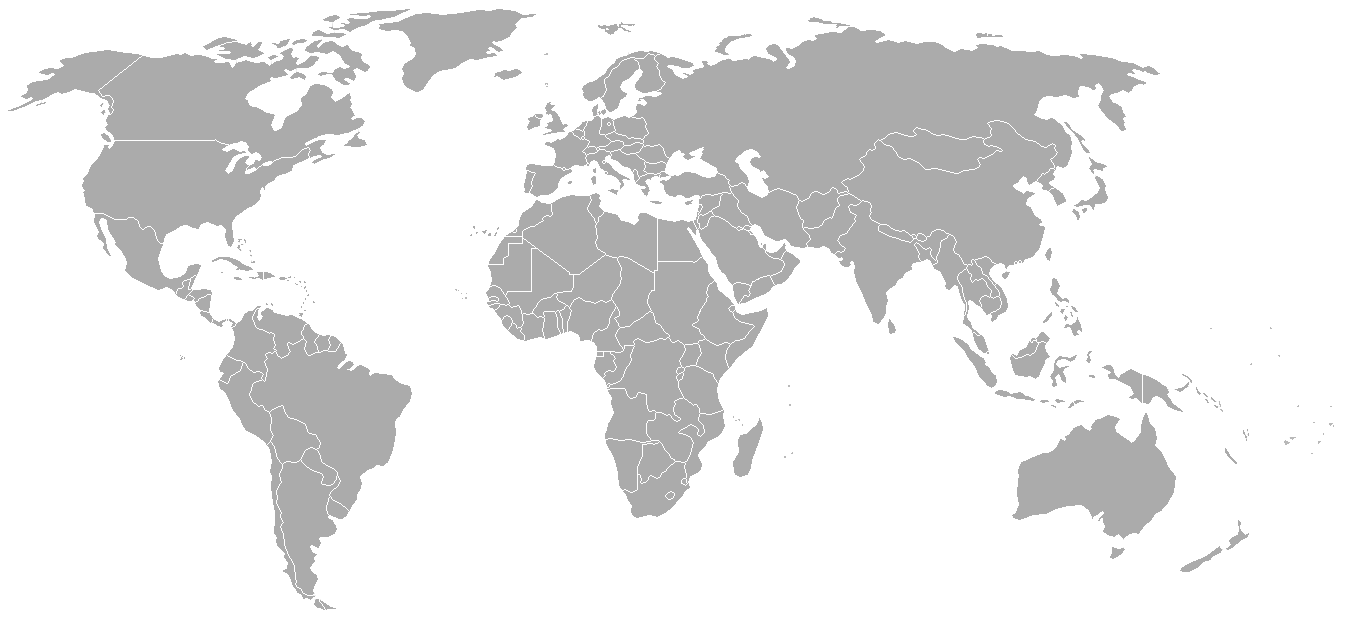
World map with 1962 borders. This is accurate between July 1, 1962 (Belgian colony of Ruanda-Urundi separated into Rwanda and Burundi.) and August 31, 1963 (Singapore, Sabah, Sarawak and Malaya join to form Malaysia). See list for more information.
| Blank maps of the world for historical use | |
| pre-1800 | |
|
19th century | |
|
20th century | |
|
1902 · 1912 · 1914 · WWI · Aug 1918 · 1920 · 1921 · 1924 · 1926 · 1935 · 1937 · Mar 1938 · Oct 1938 · Mar 1939 · Oct 1939 · WWII · Nov 1942 · May 1945 · 1957 · 1959 · 1962 · 1968 · 1970 · 1985 · 1990 · 1993 | |
|
21st century | |
| (this template: · view · discuss ) | |
.PNG)
derivative works
Derivative works of this file: FLN soccer team visited countries.png
الترخيص

|
يسمح بنسخ و توزيع و / أو تعديل الوثيقه دى تحت شروط رخصة جنو للوثائق الحره، الإصدار 1.2 أو أى إصدار تنشره مؤسسة البرمجيات الحره؛ بدون أقسام ثابته و بدون نصوص أغلفه أماميه و بدون نصوص أغلفه خلفيه. نسخه من الرخصه متضمنه ف قسم اسمه GNU Free Documentation License.http://www.gnu.org/copyleft/fdl.htmlGFDLGNU Free Documentation Licensetruetrue |
| الملف ده مترخص حسب رخصة المشاع الإبداعى نسبة المصنف للى مألفه - المشاركة بالمثل 3.0 العامه | ||
| ||
| تمت إضافة علامة الترخيص لهذا الملف كجزء من رخصة جنو للوثائق الحرة تحديث الترخيص.http://creativecommons.org/licenses/by-sa/3.0/CC BY-SA 3.0Creative Commons Attribution-Share Alike 3.0truetrue |
الشروحات
العناصر المصورة في هذا الملف
يُصوِّر العربية
نوع الوسائط العربية
image/png
تدقيق المجموع العربية
7f27b6077fa7fad8151d35c3981b25026e2e521d
حجم البيانات العربية
49,120 بايت
الارتفاع العربية
628 بكسل
1,357 بكسل
تاريخ الفايل
اضغط على الساعه/التاريخ علشان تشوف الفايل زى ما كان فى الوقت ده.
| الساعه / التاريخ | صورة صغيرة | ابعاد | يوزر | تعليق | |
|---|---|---|---|---|---|
| دلوقتي | 02:49، 24 سبتمبر 2007 | | 1,357 × 628 (48 كيلوبايت) | Hoshie | put the (N/S) Yemen boundary in white due to the fact the boundaries in southern Saudi Arabia have been disputed, undemarcated, or undisclosed over the years. |
| 00:43، 6 اغسطس 2007 |  | 1,357 × 628 (48 كيلوبايت) | Hoshie | Added Cabinda; under same lic. as original. | |
| 10:27، 28 يناير 2007 |  | 1,357 × 628 (48 كيلوبايت) | Hoshie | added Ifni, a Spanish enclave. | |
| 23:54، 5 يناير 2007 |  | 1,357 × 628 (48 كيلوبايت) | Roke~commonswiki | Blank world map with 1962 borders. This is accurate between December 19, 1961 (India takes over the Portugese colony of Goa) and July 1, 1962 (Belgian colony of Ruanda-Urundi separated into Rwanda and Burundi.) See [[w:List of national border changes sinc |
استخدام الفايل
مافيش صفحات بتوصل للفايل ده.
استخدام الملف العام
الويكيات التانيه دى بتستخدم الفايل ده:
- الاستخدام ف ca.wikipedia.org
- الاستخدام ف es.wikipedia.org
- الاستخدام ف fr.wikipedia.org
- الاستخدام ف nl.wikipedia.org