File:World_ocean_map-fr.gif
From Wikipedia, the free encyclopedia
ܠܝܬ ܢܩܕܘܬܐ ܝܬܝܪ ܡܢ ܗܢܐ.
World_ocean_map-fr.gif (500 × 500 ܦܩܣܠ، ܥܓܪܐ ܕܠܦܦܐ: 108 KB، ܐܕܫܐ ܕ MIME: image/gif, looped, 4 frames, 10 s)
This file is from Wikimedia Commons and may be used by other projects. The description on its file description page there is shown below.
| DescriptionWorld ocean map-fr.gif |
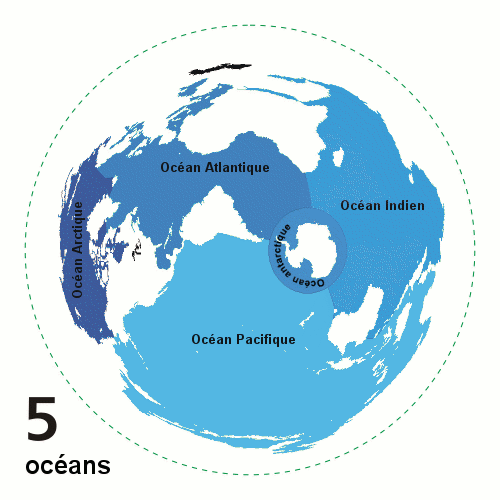
English: Animated world ocean map (GIF), exhibiting various oceans.
Azimuthal distance projection map is based on world map from this online Java tool by Henry Bottomley and altered using CorelDraw/PhotoPaint, et al. Map is centered on 85° W, 45° S, rotated 90° CCW (North Pole is to the left). Ocean boundaries per International Hydrographic Organisation.
|
|||
| ܣܝܩܘܡܐ | ||||
| ܡܒܘܥܐ | Own work, french translation of Image:World ocean map.gif created by User:Quizatz Haderach, based on Image:Oceans.png and animated design inspired by Image:Continental models.gif. | |||
| ܣܝܘܡܐ | Emmanuel.boutet | |||
| Permission (Reusing this file) |
|
|||
| Other versions |
 |
This image was improved or created by the Wikigraphists of the Graphic Lab (fr). You can propose images to clean up, improve, create or translate as well. |
Captions
Add a one-line explanation of what this file represents
Items portrayed in this file
depicts English
creator English
some value
inception English
8 ܒܬܫܪܝܢ ܩܕܡ 2007
ܬܫܥܝܬܐ ܕܠܦܦܐ
Click on a date/time to view the file as it appeared at that time.
| ܣܝܩܘܡܐ/ܙܒܢܐ | ܨܘܪܬܐ ܙܥܘܪܬܐ | ܩܝܡ̈ܐ | ܡܦܠܚܢܐ | ܥܘܩܒܐ | |
|---|---|---|---|---|---|
| ܗܫܝܐ | 10:23, 8 ܒܬܫܪܝܢ ܩܕܡ 2007 | | 500 × 500 (108 KB) | Emmanuel.boutet | |
| 08:50, 8 ܒܬܫܪܝܢ ܩܕܡ 2007 |  | 500 × 500 (108 KB) | Emmanuel.boutet | {{Information |Description= {{en|Animated world ocean map (GIF), exhibiting various oceans. Created by User:Quizatz Haderach, based on Image:Oceans.png and animated design inspired by Image:Continental models.gif. Azimuthal distance projec |
ܡܦܠܚܬܐ ܕܠܦܦܐ
ܠܝܬ ܦܐܬܐ ܕܐܣܪ ܠܗܢܐ ܠܦܦܐ.
ܡܦܠܚܢܘܬܐ ܓܘܢܝܬܐ ܕܠܦܦܐ
The following other wikis use this file:
- Usage on fr.wikipedia.org
- Usage on gcr.wikipedia.org
- Usage on hu.wikipedia.org
- Usage on incubator.wikimedia.org
- Usage on nap.wikipedia.org
- Usage on vec.wikipedia.org
- Usage on zgh.wikipedia.org
Retrieved from "https://arc.wikipedia.org/wiki/ܠܦܦܐ:World_ocean_map-fr.gif"