ملف:Britannica_Figure_of_the_Earth.jpg
من ويكيبيديا، الموسوعة encyclopedia
الملف الأصلي (525 × 907 بكسل حجم الملف: 84 كيلوبايت، نوع MIME: image/jpeg)
| هذا ملف من ويكيميديا كومنز. معلومات من صفحة وصفه مبينة في الأسفل. كومنز مستودع ملفات ميديا ذو رخصة حرة. |
ملخص
| الوصفBritannica Figure of the Earth.jpg |
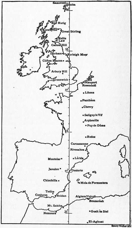
English: A meridian arc extending from the Shetland Islands, through Great Britain, France and Spain to El Aghuat in Algeria, whose parameters were calculated from surveys carried out in the mid to late 19th century. It yielded a value for the equatorial radius of the earth a = 6 377 935 metres, the ellipticity being assumed as 1/299.15. The radius of curvature of this arc is not uniform, being, in the mean, about 600 metres greater in the northern than in the southern part. The Greenwich meridian is depicted rather than the Paris meridian. |
| التاريخ | |
| المصدر | Encyclopædia Britannica, 1911 |
| المؤلف | Encyclopædia Britannica, Volume 8, Slice 9., available freely at Project Gutenberg |
ترخيص
| Public domainPublic domainfalsefalse |
| This image comes from the 13th edition of the Encyclopædia Britannica or earlier. The copyrights for that book have expired in the United States because the book was first published in the US with the publication occurring before January 1, 1929. As such, this image is in the public domain in the United States. |  |
| Public domainPublic domainfalsefalse |
| This image comes from the Project Gutenberg archives. This is an image that has come from a book or document for which the American copyright has expired and this image is in the public domain in the United States and possibly other countries.
This eBook is for the use of anyone anywhere at no cost and with almost no restrictions whatsoever. You may copy it, give it away or re-use it under the terms of the Project Gutenberg License included with this eBook or online at www.gutenberg.net. |
الشروحات
العناصر المصورة في هذا الملف
يُصوِّر
1911
image/jpeg
9553129554fbf9f3a78fe3eea580165af7339d8b
٨٦٬٤٤٤ بايت
٩٠٧ بكسل
٥٢٥ بكسل
تاريخ الملف
اضغط على زمن/تاريخ لرؤية الملف كما بدا في هذا الزمن.
| زمن/تاريخ | صورة مصغرة | الأبعاد | مستخدم | تعليق | |
|---|---|---|---|---|---|
| حالي | 16:46، 19 فبراير 2011 | | 525 × 907 (84 كيلوبايت) | Keith Edkins | =={{int:filedesc}}== {{Information |Description={{en|A meridian arc extending from the Shetland Islands, through Great Britain, France and Spain to El Aghuat in Algeria, whose parameters were calculated from surveys carried out in the mid to late 19th cen |
استخدام الملف
الصفحتان التاليتان تستخدمان هذا الملف:
الاستخدام العالمي للملف
الويكيات الأخرى التالية تستخدم هذا الملف:
- الاستخدام في en.wikipedia.org
- الاستخدام في en.wikisource.org
- الاستخدام في es.wikipedia.org
- الاستخدام في fr.wikipedia.org
- الاستخدام في gl.wikipedia.org
- الاستخدام في ru.wikipedia.org
- الاستخدام في sl.wikipedia.org
- الاستخدام في uk.wikipedia.org
بيانات وصفية
هذا الملف يحتوي على معلومات إضافية، غالبا ما تكون أضيفت من قبل الكاميرا الرقمية أو الماسح الضوئي المستخدم في إنشاء الملف.
إذا كان الملف قد عدل عن حالته الأصلية، فبعض التفاصيل قد لا تعبر عن الملف المعدل.
| _error | 0 |
|---|