File:Earth's_City_Lights_by_DMSP,_1994-1995_(medium).png
من ويكيبيديا، الموسوعة encyclopedia
الملف الأصلي (2٬560 × 1٬280 بكسل حجم الملف: 2٫56 ميجابايت، نوع MIME: image/png)
| هذا ملف من ويكيميديا كومنز. معلومات من صفحة وصفه مبينة في الأسفل. كومنز مستودع ملفات ميديا ذو رخصة حرة. |
ملخص
| الوصفEarth's City Lights by DMSP, 1994-1995 (medium).png |
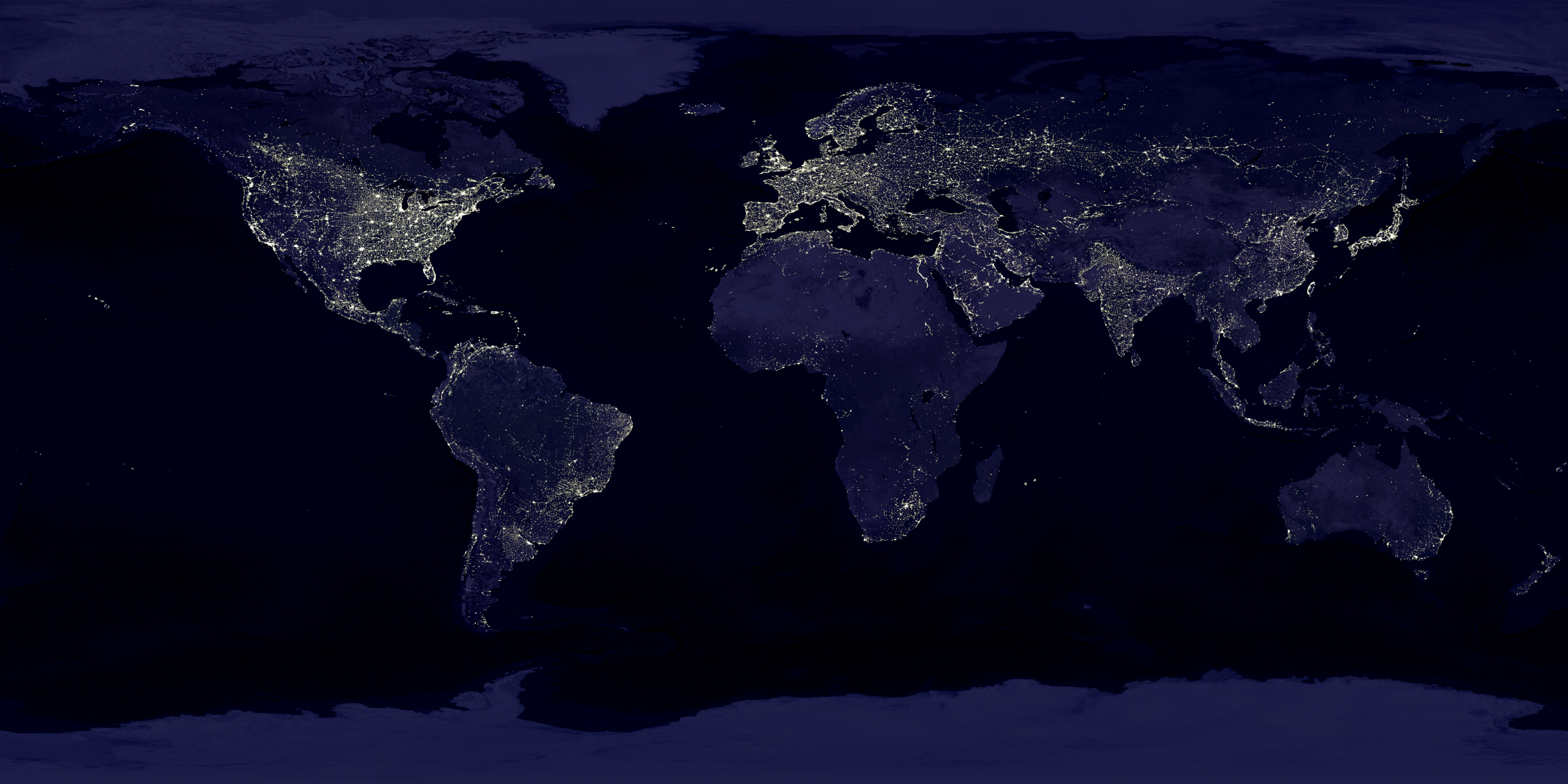
English: This image of Earth’s city lights was created with data from the Defense Meteorological Satellite Program (DMSP) Operational Linescan System (OLS). Originally designed to view clouds by moonlight, the OLS is also used to map the locations of permanent lights on the Earth’s surface.
The brightest areas of the Earth are the most urbanized, but not necessarily the most populated. (Compare western Europe with China and India.) Cities tend to grow along coastlines and transportation networks. Even without the underlying map, the outlines of many continents would still be visible. The United States interstate highway system appears as a lattice connecting the brighter dots of city centers. In Russia, the Trans-Siberian railroad is a thin line stretching from Moscow through the center of Asia to Vladivostok. The Nile River, from the Aswan Dam to the Mediterranean Sea, is another bright thread through an otherwise dark region. Even more than 100 years after the invention of the electric light, some regions remain thinly populated and unlit. Antarctica is entirely dark. The interior jungles of Africa and South America are mostly dark, but lights are beginning to appear there. Deserts in Africa, Arabia, Australia, Mongolia, and the United States are poorly lit as well (except along the coast), along with the boreal forests of Canada and Russia, and the great mountains of the Himalaya. |
| التاريخ |
بين ١ أكتوبر ١٩٩٤ و ٣١ مارس ١٩٩٥ date QS:P,+1994-00-00T00:00:00Z/8,P1319,+1994-10-01T00:00:00Z/11,P1326,+1995-03-31T00:00:00Z/11 |
| المصدر | https://visibleearth.nasa.gov/view.php?id=55167 (image link) |
| المؤلف | Data: Marc Imhoff/NASA GSFC, Christopher Elvidge/NOAA NGDC; Image: Craig Mayhew and Robert Simmon/NASA GSFC |
| إصدارات أخرى |
|
.jpg)
.jpg)
.png)

ترخيص
| Public domainPublic domainfalsefalse |
| يقع هذا العمل في النِّطاق العامّ في الولايات المُتحدة الأمريكيَّة لأَنَّه عملٌ خالِصٌ من إِنتاج وكالة الفضاء الأمريكيَّة. تنصُ حقوق التَّأليف والنَّشر الخاصَّة بوكالة الفضاء الأمريكيَّة على أنَّ "أعمال الوكالة غير مَحميَّة بحقوق التَّأليف والنَّشر ما لم يُذكر خلافُ ذلك". لمزيدٍ من المعلومات انظر القالِب {{PD-USGov}} وصفحة حقوق التَّأليف والنَّشر الخاصَّة بالوكالة وصفحة سياسة الصُّور الخاصَّة بمُختبر الدَّفع النَّفَّاث. | ||
 |
تنبيهات:
|
| Public domainPublic domainfalsefalse |
تحتوي هذه الصُّورة مواداً أنتجت بواسطة الإدارة الوطنيَّة للمحيطات والغلاف الجوي في الولايات المتَّحدة الأمريكيَّة. أُنشئت هذه المواد مِن قبل مُوظَّفٍ خلال أدائه لواجباته الرَّسميَّة أي أنَّها عملٌ من أعمال الحكومة الاتحاديَّة للولايات المتَّحدة، ولذلك فهي في النِّطاق العامِّ.
العربية ∙ čeština ∙ Deutsch ∙ Zazaki ∙ English ∙ español ∙ eesti ∙ suomi ∙ français ∙ hrvatski ∙ magyar ∙ italiano ∙ 日本語 ∙ 한국어 ∙ македонски ∙ മലയാളം ∙ Plattdüütsch ∙ Nederlands ∙ polski ∙ português ∙ română ∙ русский ∙ sicilianu ∙ slovenščina ∙ Türkçe ∙ Tiếng Việt ∙ 简体中文 ∙ 繁體中文 ∙ +/− |
الشروحات
العناصر المصورة في هذا الملف
يُصوِّر
image/png
تاريخ الملف
اضغط على زمن/تاريخ لرؤية الملف كما بدا في هذا الزمن.
| زمن/تاريخ | صورة مصغرة | الأبعاد | مستخدم | تعليق | |
|---|---|---|---|---|---|
| حالي | 18:49، 15 أبريل 2017 | | 2٬560 × 1٬280 (2٫56 ميجابايت) | Huntster | Standardise appearance in series. |
| 20:45، 9 مارس 2009 |  | 2٬560 × 1٬364 (2٫18 ميجابايت) | Tryphon | Higher resolution. | |
| 15:05، 18 سبتمبر 2007 |  | 1٬499 × 797 (658 كيلوبايت) | Jonathan Kovaciny~commonswiki | Re-cropped version of original NASA image. | |
| 15:03، 18 سبتمبر 2007 |  | 1٬521 × 797 (667 كيلوبايت) | Jonathan Kovaciny~commonswiki | Cropped version of the original NASA image. | |
| 16:26، 30 مارس 2007 |  | 1٬500 × 1٬125 (1٫61 ميجابايت) | Laur2ro | {{Information |Description=Earth lights, image is slightly edited (increased contrast and brightness; similar to Image:Whole world - at night.png, but the continents are visible also). |Source=http://visibleearth.nasa.gov/view_rec.php?id=11793 |Date=m |
استخدام الملف
الصفحة التالية تستخدم هذا الملف:
الاستخدام العالمي للملف
الويكيات الأخرى التالية تستخدم هذا الملف:
- الاستخدام في ca.wikipedia.org
- الاستخدام في en.wikipedia.org
- الاستخدام في en.wikiquote.org
- الاستخدام في en.wikiversity.org
- الاستخدام في es.wikinews.org
- الاستخدام في fr.wikipedia.org
- الاستخدام في fr.wikiversity.org
- الاستخدام في ha.wikipedia.org
- الاستخدام في hi.wikipedia.org
- الاستخدام في hr.wikipedia.org
- الاستخدام في it.wikipedia.org
- الاستخدام في mwl.wikipedia.org
- الاستخدام في pl.wikipedia.org
- الاستخدام في ru.wikipedia.org
- الاستخدام في sh.wikipedia.org
- الاستخدام في uk.wikipedia.org
- الاستخدام في uz.wikipedia.org
- الاستخدام في www.wikidata.org
بيانات وصفية
هذا الملف يحتوي على معلومات إضافية، غالبا ما تكون أضيفت من قبل الكاميرا الرقمية أو الماسح الضوئي المستخدم في إنشاء الملف.
إذا كان الملف قد عدل عن حالته الأصلية، فبعض التفاصيل قد لا تعبر عن الملف المعدل.
| تاريخ ووقت تغيير الملف | 18:47، 15 أبريل 2017 |
|---|---|
| الدقة الأفقية | 15٫11 دي بي سي |
| الدقة الرأسية | 15٫11 دي بي سي |
.png)