ስዕል:Colonisation_1885.png
From Wikipedia, the free encyclopedia
ዋና ፋይል (1,200 × 526 ፒክስል፤ መጠን፦ 206 KB፤ የMIME ዓይነት፦ image/png)
ይህ ፋይል ከWikimedia Commons የተቀሰመ ነው እና በሌላ ዊኪ ላይ ሊጠቅም ይችላል። በhttps://commons.wikimedia.org/wiki/File:Colonisation_1885.png ላይ የሚገኘው የፋይሉ መግለጫ ከዚህ በታች ቀርቧል።
| References for this description (or part of this) or for the depiction in the file are not provided. |
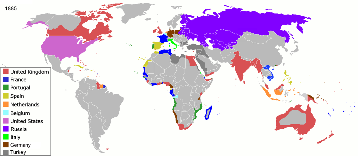
| ማጠቃለያColonisation 1885.png |
Map of major world powers by year, derived from public domain animated map on wikipedia.
As the orriginal licence of the animation was Public Domain, this image which has been derived from it is too:
|
|||||||||||||||||||
| ቀን | ||||||||||||||||||||
| ምንጭ | public domain animated map by ArdadN here | |||||||||||||||||||
| አቅራቢው | ArdadN | |||||||||||||||||||
.jpg)
._LOC_2001620596.jpg)

|
This historical map image could be re-created using vector graphics as an SVG file. This has several advantages; see Commons:Media for cleanup for more information. If an SVG form of this image is available, please upload it and afterwards replace this template with
{{vector version available|new image name}}.
It is recommended to name the SVG file “Colonisation 1885.svg”—then the template Vector version available (or Vva) does not need the new image name parameter. |
Captions
inception እንግሊዝኛ
22 ማርች 2007
media type እንግሊዝኛ
image/png
checksum እንግሊዝኛ
831fd10c262a996a3291205f48ebb3278f0cca4d
data size እንግሊዝኛ
210,626 byte
526 pixel
width እንግሊዝኛ
1,200 pixel
የፋይሉ ታሪክ
የቀድሞው ዕትም ካለ ቀን/ሰዓቱን በመጫን መመልከት ይቻላል።
| ቀን /ሰዓት | ናሙና | ክልሉ (በpixel) | አቅራቢው | ማጠቃለያ | |
|---|---|---|---|---|---|
| ያሁኑኑ | 09:05, 8 ኖቬምበር 2021 | | 1,200 × 526 (206 KB) | Randomastwritter | jubaland |
| 09:52, 5 ኤፕሪል 2020 |  | 1,200 × 526 (206 KB) | Ориенталист | South Sakhalin was part of Russia in 1885 | |
| 11:17, 2 ሜይ 2015 |  | 1,425 × 625 (49 KB) | Chrischerf | German Empire and colonies in 1885; Sudan under control of the Mahdi | |
| 02:57, 3 ኦገስት 2014 |  | 1,425 × 625 (54 KB) | Alvin Lee | correcting the boundaries of Russia and China | |
| 13:54, 3 ኖቬምበር 2013 |  | 1,425 × 625 (78 KB) | McZusatz | Reverted to version as of 00:22, 24 January 2011 [corrupt file?] | |
| 15:24, 3 ኖቬምበር 2012 |  | 1,425 × 625 (67 KB) | Franco310397 | Spanish presence in Micronesia (Oceania) included in the Captaincy General of the Philippines. In the Caroline Islands and the Mariana Islands. | |
| 00:22, 24 ጃንዩዌሪ 2011 |  | 1,425 × 625 (78 KB) | Micsha~commonswiki | Reverted to version as of 02:17, 3 May 2010 | |
| 00:22, 24 ጃንዩዌሪ 2011 |  | 506 × 326 (85 KB) | Micsha~commonswiki | Only Africa; includes map key | |
| 02:17, 3 ሜይ 2010 |  | 1,425 × 625 (78 KB) | Kieran4 | slight edit | |
| 02:14, 3 ሜይ 2010 |  | 1,425 × 625 (78 KB) | Kieran4 | Correct Dutch East INdies |
መያያዣዎች
የሚከተለው ገጽ ወደዚሁ ፋይል ተያይዟል፦
ሌሎች ውኪዎች
የሚከተሉት ሌሎች ውኪዎች ይህን ፋይል ይጠቀማሉ፦
- Usage on de.wikipedia.org
- Usage on en.wikipedia.org
- Usage on es.wikipedia.org
- Usage on fr.wikipedia.org
- Usage on he.wikipedia.org
- Usage on oc.wikipedia.org
- Usage on sk.wikipedia.org
ተጨማሪ መረጃ
ይህ ፋይል በውስጡ ተጨማሪ መረጃ ይይዛል። መረጃውም በዲጂታል ካሜራ ወይም በኮምፒውተር ስካነር የተጨመረ ይሆናል። ይህ ከኦሪጂናሉ ቅጅ የተለወጠ ከሆነ፣ ምናልባት የመረጃው ዝርዝር ለውጦቹን የማያንጸባረቅ ይሆናል።
| PNG file comment | |
|---|---|
| አድማሳዊ ማጉላት | 47.24 dpc |
| ቁም ማጉላት | 47.24 dpc |
| የተጠቀመው ሶፍትዌር |
|