File:United_States_1846-12-1848-02.png
From Wikipedia, the free encyclopedia
Greßi vu däre Vorschau: 800 × 542 Pixel. Wyteri Ufflösige: 320 × 217 Pixel | 640 × 433 Pixel | 1.000 × 677 Pixel.
Originaldatei (1.000 × 677 Pixel, Dateigrößi: 87 KB, MIME-Typ: image/png)
| Die Datei un d Informatione derzue were us em zäntrale Mediearchiv Wikimedia Commons (Allmänd) iibunde. | Zur Bschriibigssite uff de Allmänd |
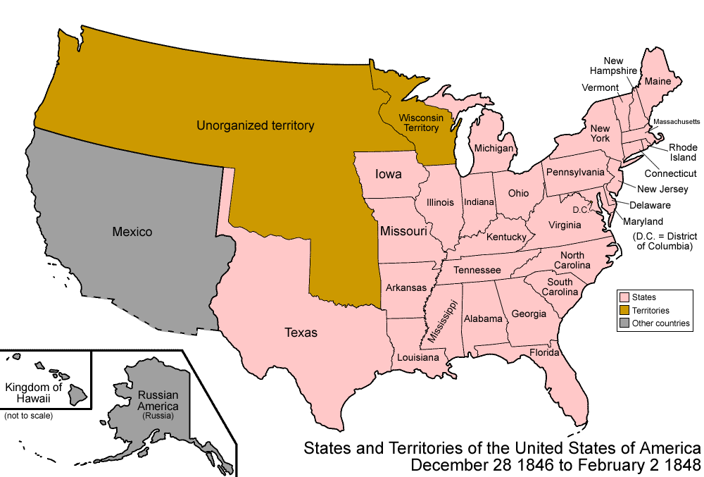
| BschryybigUnited States 1846-12-1848-02.png | Map of the states and territories of the United States as it was from December 1846 to February 1848. On December 28 1846, a portion of Iowa Territory was admitted as the state of Iowa; the remainder became unorganized. On February 2 1848, as a result of the Mexican-American War, Mexico ceded a large portion of its land to the United States. |
| Quälle | Eigeni Arbet |
| Urheber | Made by User:Golbez. |
| Gnähmigung (Wyternutzig vu däre Datei) |
Own work, attribution required (Multi-license with GFDL and Creative Commons CC-BY 2.5) |
| Anderi Versione |
Abgleiteti Wärk vo dere Datei: |
Ich haa s Urheberrächt an däm Wärch un vereffetlig s dodermit unter däne Lizänze:

|
Des Dokumänt derf kopiert, verbreitet un/oder bearbeitet wäre unter dr Bedingige vu dr GNU-Lizänz fir freji Dokumäntation, Version 1.2 oder ere spetere Version, vereffetligt dur Free Software Foundation. S het keini uuveränderlige Abschnitt, kei vordere Umschlagstext un kei hindere Umschlagstext. E Kopii vu dr Lizänz isch verfiegbar im Abschnitt GNU-Lizänz fir freji Dokumäntation.http://www.gnu.org/copyleft/fdl.htmlGFDLGNU Free Documentation Licensetruetrue |
| Die Datei isch lizänziert unter dr Creative-Commons-Lizenz Namensnännig – Wytergab unter glyche Bedingige 3.0 nit portiert. | ||
| ||
| Die Lizänzmarkierig isch wäg em GFDL-Lizänzupdate zuegfiegt wore.http://creativecommons.org/licenses/by-sa/3.0/CC BY-SA 3.0Creative Commons Attribution-Share Alike 3.0truetrue |
Die Datei isch lizänziert unter dr Creative-Commons-Lizänz Namensnännig 2.5 generisch.
- Du derfsch:
- des Wärch an anderi wytergee – des Wärch kopiere, verbreite un ibertrage
- des Wärch verändere – des Wärch aapasse
- Unter däne Bedingige:
- Namenännig – Du muesch aagmässeni Aagabe zum Urheber un dr Rächt mache, e Link zue dr Lizänz zuefiege un aagee, eb Änderige gmacht wore sin. Die Aagabe chenne in ere aagmässene Art gmacht wäre, aber nit eso, ass dr Yydruck entstoht, ass dr Lizänzgeber Dii oder Dyy Gebruch vum Wärch unterstitze un guetheiße.
Du chasch sälber e Lizänz uuswehle.
| Territorial evolution maps of the United States |
| v · d (template shows date of beginning of change yyyy-mm-dd) |
| 1789-03, 1789-08, 1790-04, 1790-05, 1791-03, 1791-09, 1792-03, 1792-06, 1795, 1796, 1798, 1800-07-04, 1800-07, 1802, 1803-03, 1803-04, 1804-03, 1804-10, 1805-01, 1805-07, 1809, 1810-04, 1810-10, 1812-04, 1812-05, 1812-06, 1816, 1817-03, 1817-12, 1818-10, 1818-12, 1819-03, 1819-12, 1820, 1821-07, 1821, 1822, 1824, 1828, 1834, 1836-03, 1836-06, 1836-07, 1837-01, 1837-03, 1838, 1842, 1845-03, 1845-12, 1846-06, 1846-12, 1848-02, 1848-05, 1848-08, 1849, 1850, 1853-03, 1853-12, 1854, 1858, 1859, 1860, 1861-01, 1861-02-04, 1861-02-28, 1861-03, 1861-08, 1862, 1863-02, 1863-03, 1863-06, 1864-05, 1864-10, 1865, 1866, 1867-01, 1867-03, 1867-10, 1868, 1876, 1884, 1889-11-02, 1889-11-08, 1889-11-11, 1890-05, 1890-07-03, 1890-07-10, 1896-01, 1896-05, 1898, 1907, 1912-01, 1912-02, 1912-08, 1959-01, 1959-08 |
as a
Kurzbeschreibungen
Ergänze eine einzeilige Erklärung, was diese Datei darstellt.
In dieser Datei abgebildete Objekte
Motiv
Urheberrechtsstatus Tüütsch
urheberrechtlich geschützt Tüütsch
Quelle der Datei Tüütsch
Dateiversione
Klick uf e Zytpunkt zu aazeige, wie s dert usgsäh het.
| Version vom | Vorschaubild | Mäß | Benutzer | Kommentar | |
|---|---|---|---|---|---|
| aktuell | 09:04, 29. Jul. 2006 | | 1.000 × 677 (87 KB) | Golbez | {{Information| |Description=Map of the states and territories of the United States as it was from |Source= |Date= |Author=Made by User:Golbez. |Permission=Own work, attribution required (Multi-license with GFDL and Creative Commons CC-BY 2.5) |other_ |
Verwändig vu dr Datei
Kei Artikel bruucht die Datei.
Wältwyti Dateinutzig
Die andere Wikis bruche die Datei:
- Gebruch uf de.wikipedia.org
- Gebruch uf en.wikipedia.org
- Gebruch uf es.wikipedia.org
- Gebruch uf fr.wikipedia.org
- Gebruch uf ja.wikipedia.org
- Gebruch uf vi.wikipedia.org
- Gebruch uf zh.wikipedia.org