File:Nagorno-Karabakh_Republic_(orthographic_projection)_v1.png
From Wikipedia, the free encyclopedia
Greßi vu däre Vorschau: 603 × 599 Pixel. Wyteri Ufflösige: 242 × 240 Pixel | 617 × 613 Pixel.
Originaldatei (617 × 613 Pixel, Dateigrößi: 120 KB, MIME-Typ: image/png)
| Die Datei un d Informatione derzue were us em zäntrale Mediearchiv Wikimedia Commons (Allmänd) iibunde. | Zur Bschriibigssite uff de Allmänd |
| BschryybigRepublic of Artsakh (orthographic projection) v1.png |
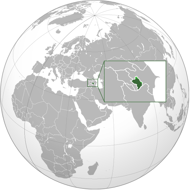
English: Orthographic Projection Map of the Nagorno-Karabakh Republic Dark Green represents areas under ethnic Armenian military control, light green represents areas claimed by the republic, under Azerbaijan government control. |
| Datum | (UTC) |
| Quälle | |
| Urheber |
|
.svg)
| Dieses Bild wurde digital nachbearbeitet. Folgende Änderungen wurden vorgenommen: made the location of NKR more clear on the world map. Das Originalbild kann hier eingesehen werden: Nagorno-Karabakh Republic (orthographic projection).svg:
|
| Public domainPublic domainfalsefalse |
| Diese Datei ist gemeinfrei („public domain“), weil sie nur Allgemeingut enthält und die nötige Schöpfungshöhe nicht erreicht. |
Orginal Logbuech vu uffegladene Datei
This image is a derivative work of the following images:
- File:Nagorno-Karabakh_Republic_(orthographic_projection).svg licensed with PD-ineligible
- 2010-02-23T00:53:47Z Kentronhayastan 550x550 (594491 Bytes) cleaned up the fixed borders
- 2010-02-21T11:04:39Z Dinamik 550x550 (655950 Bytes) some more information about territory
- 2010-02-12T12:42:58Z Justass 550x550 (586396 Bytes) Reverted to version as of 10:24, 27 January 2010
- 2010-02-12T12:40:31Z Maulucioni 550x550 (105958 Bytes) to png
- 2010-01-27T10:24:54Z Kentronhayastan 550x550 (586396 Bytes) adjusted map size
- 2010-01-27T10:19:16Z Kentronhayastan 550x550 (586344 Bytes) {{Information |Description={{en|1=Orthographic Projection Map of the Nagorno-Karabakh Republic}} |Source=Ssolbergj's work |Author=kentronhayastan, Ssolbergj |Date= |Permission= |other_versions= }}
Hochgeladen mit derivativeFX
Kurzbeschreibungen
Ergänze eine einzeilige Erklärung, was diese Datei darstellt.
In dieser Datei abgebildete Objekte
Motiv
11. Jänner 2011
Dateiversione
Klick uf e Zytpunkt zu aazeige, wie s dert usgsäh het.
| Version vom | Vorschaubild | Mäß | Benutzer | Kommentar | |
|---|---|---|---|---|---|
| aktuell | 20:46, 11. Jan. 2011 | | 617 × 613 (120 KB) | Ashot Arzumanyan | {{Information |Description={{en|1=Orthographic Projection Map of the Nagorno-Karabakh Republic}} Dark Green represents areas under ethnic Armenian military control, light green represents areas claimed by the republic, under Azerbaijan government control. |
Verwändig vu dr Datei
Kei Artikel bruucht die Datei.
Wältwyti Dateinutzig
Die andere Wikis bruche die Datei:
- Gebruch uf en.wikipedia.org
- Gebruch uf fa.wikipedia.org
- Gebruch uf hy.wikipedia.org
_v1.png)