Lêer:Sulawesi_map.PNG
From Wikipedia, the free encyclopedia
Grootte van hierdie voorskou: 543 × 599 piksels. Ander resolusies: 217 × 240 piksels | 435 × 480 piksels | 696 × 768 piksels | 928 × 1 024 piksels | 1 492 × 1 647 piksels.
Oorspronklike lêer (1 492 × 1 647 piksels, lêergrootte: 83 KG, MIME-tipe: image/png)
Hierdie lêer kom vanaf Wikimedia Commons en kan ook in ander projekte gebruik word. Die beskrywing op die lêer se inligtingsblad word hieronder weergegee.
Opsomming
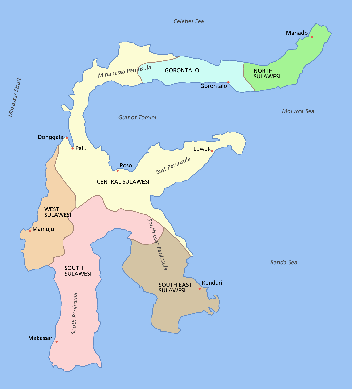
Sulawesi showing provinces, their capital cities, a few other cities and some surrounding areas of water. Note that there are other islands in this area which are not shown as this is a map of Sulawesi island itself.
For a blank map see Image:Sulawesi blank.PNG
derivative works
Derivative works of this file: Sulawesi map id.png
Lisensiëring

|
Toestemming word verleen tot die kopiëring, verspreiding en/of wysiging van hierdie dokument onder die voorwaardes van die GNU-lisensie vir vrye dokumentasie, weergawe 1.2 of enige latere weergawe uitgegee deur die Stigting vir Vrye Sagteware, sonder Invariante Dele, geen Voorbladtekste en geen Agterbladtekste. 'n Kopie van hierdie lisensie is ingesluit in die afdeling getiteld GNU Free Documentation License.http://www.gnu.org/copyleft/fdl.htmlGFDLGNU Free Documentation Licensetruetrue |
| Hierdie lêer is gelisensieer onder die Creative Commons Erkenning-Insgelyks Deel 3.0 Onoorgedraagde lisensie. | ||
| ||
| This licensing tag was added to this file as part of the GFDL licensing update.http://creativecommons.org/licenses/by-sa/3.0/CC BY-SA 3.0Creative Commons Attribution-Share Alike 3.0truetrue |
Captions
Add a one-line explanation of what this file represents
Items portrayed in this file
uitbeelding
Lêergeskiedenis
Klik op die datum/tyd om te sien hoe die lêer destyds gelyk het.
| Datum/Tyd | Duimnael | Dimensies | Gebruiker | Opmerking | |
|---|---|---|---|---|---|
| huidig | 12:11, 11 Maart 2006 | | 1 492 × 1 647 (83 KG) | Roke~commonswiki | fixed borders of provinces |
| 04:55, 11 Maart 2006 |  | 1 492 × 1 647 (82 KG) | Roke~commonswiki | Sulawesi showing provinces, their capital cities, a few other cities and some surrounding areas of water. Note that there are other islands in this area which are not shown as this is a map of Sulawesi island itself. Category:Sulawesi [[Category:Maps |
Lêergebruik
Globale lêergebruik
Die volgende ander wiki's gebruik hierdie lêer:
- Gebruik in bg.wikipedia.org
- Gebruik in bn.wikipedia.org
- Gebruik in bug.wikipedia.org
- Gebruik in ca.wikipedia.org
- Gebruik in ceb.wikipedia.org
- Gebruik in cs.wikipedia.org
- Gebruik in cy.wikipedia.org
- Gebruik in el.wikipedia.org
- Gebruik in en.wikipedia.org
- Gebruik in es.wikipedia.org
- Gebruik in eu.wikipedia.org
- Gebruik in fa.wikipedia.org
- Gebruik in fi.wikipedia.org
- Gebruik in fr.wikipedia.org
- Gebruik in ga.wikipedia.org
- Gebruik in gl.wikipedia.org
- Gebruik in gl.wiktionary.org
- Gebruik in hi.wikipedia.org
- Gebruik in hu.wikipedia.org
- Gebruik in id.wiktionary.org
- Gebruik in ilo.wikipedia.org
- Gebruik in is.wikipedia.org
- Gebruik in it.wikipedia.org
- Gebruik in ja.wikipedia.org
- Gebruik in kk.wikipedia.org
- Gebruik in km.wikipedia.org
- Gebruik in la.wikipedia.org
- Gebruik in map-bms.wikipedia.org
- Gebruik in mi.wikipedia.org
- Gebruik in ml.wikipedia.org
- Gebruik in mrj.wikipedia.org
- Gebruik in mr.wikipedia.org
- Gebruik in ms.wikipedia.org
- Gebruik in mzn.wikipedia.org
Wys meer globale gebruik van die lêer.
Ontsluit van "https://af.wikipedia.org/wiki/Lêer:Sulawesi_map.PNG"