Lêer:OrangeCountyCA_Map.gif
From Wikipedia, the free encyclopedia
Grootte van hierdie voorskou: 685 × 599 piksels. Ander resolusies: 274 × 240 piksels | 549 × 480 piksels | 878 × 768 piksels | 1 170 × 1 024 piksels | 2 341 × 2 048 piksels | 3 200 × 2 800 piksels.
Oorspronklike lêer (3 200 × 2 800 piksels, lêergrootte: 1,35 MG, MIME-tipe: image/gif)
Hierdie lêer kom vanaf Wikimedia Commons en kan ook in ander projekte gebruik word. Die beskrywing op die lêer se inligtingsblad word hieronder weergegee.

|
This locator map image could be re-created using vector graphics as an SVG file. This has several advantages; see Commons:Media for cleanup for more information. If an SVG form of this image is available, please upload it and afterwards replace this template with
{{vector version available|new image name}}.
It is recommended to name the SVG file “OrangeCountyCA Map.svg”—then the template Vector version available (or Vva) does not need the new image name parameter. |
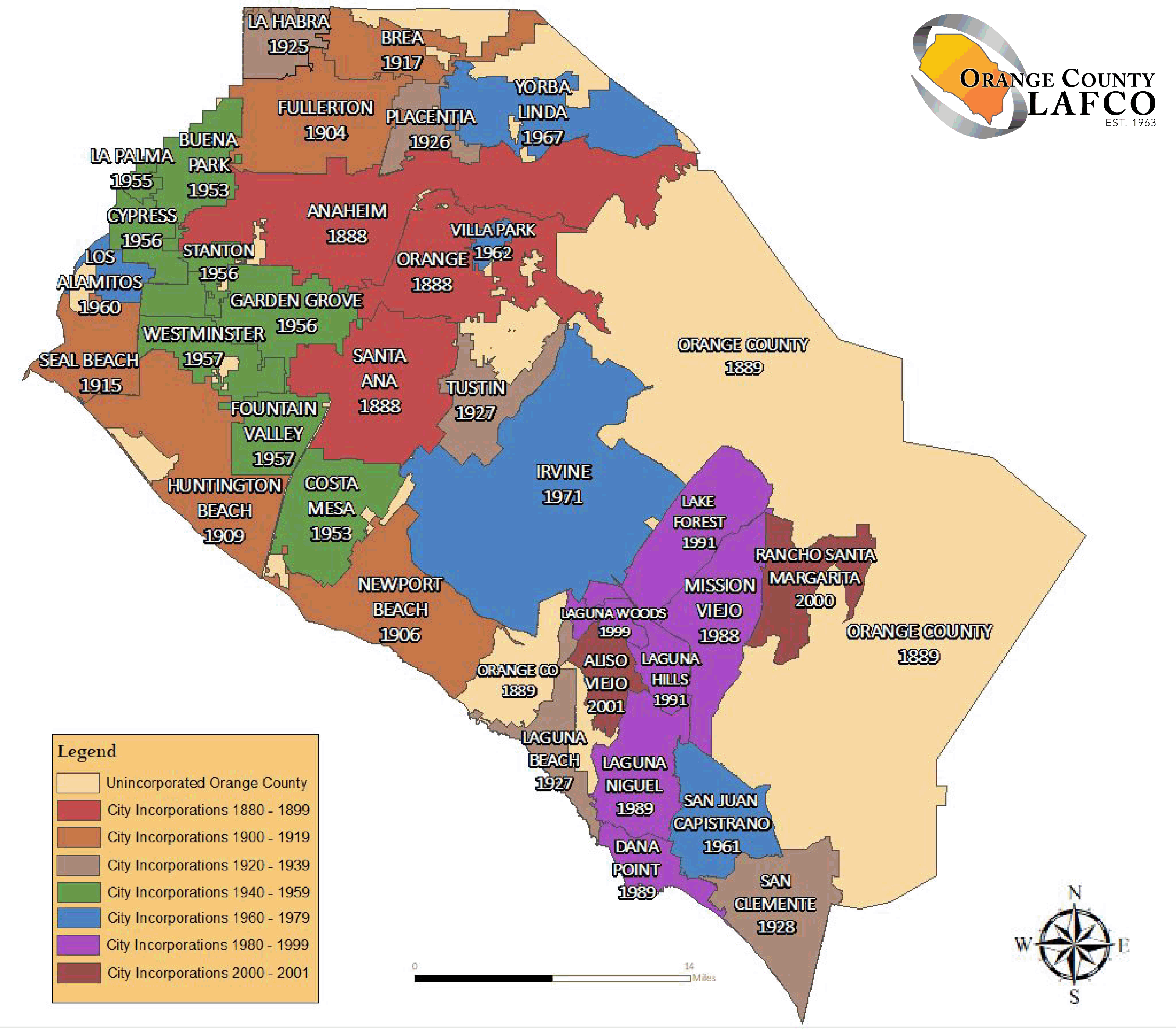
English: The en:Orange County LAFCO map of Category:Maps of Orange County with its city's boundaries.
Español: Mapa de las fronteras de las ciudades de Condado de Orange.
Français : Carte des frontières des villes du Comté d'Orange.
Source : import from English Wikipedia. http://en.wikipedia.org/wiki/Image:OrangeCountyCA_Map.gif - Author : MarsRover - public domain
| Public domainPublic domainfalsefalse |
| This work has been released into the public domain by its author, MarsRover at Engels Wikipedia. This applies worldwide. In sommige lande is dit dalk nie wettiglik moontlik nie. Indien so: MarsRover grants anyone the right to use this work for any purpose, without any conditions, unless such conditions are required by law.Public domainPublic domainfalsefalse |
Captions
Add a one-line explanation of what this file represents
[[Orange County LAFCO]]
Items portrayed in this file
uitbeelding
media type Engels
image/gif
Lêergeskiedenis
Klik op die datum/tyd om te sien hoe die lêer destyds gelyk het.
| Datum/Tyd | Duimnael | Dimensies | Gebruiker | Opmerking | |
|---|---|---|---|---|---|
| huidig | 03:36, 12 September 2019 | | 3 200 × 2 800 (1,35 MG) | Fluffy89502 | newer map per https://oclafco.org/index.php/sphere-of-influence-maps/ |
| 01:55, 30 Julie 2008 |  | 694 × 557 (29 KG) | MarsRover | {{Information |Description= |Source= |Date= |Author= |Permission= |other_versions= }} | |
| 15:35, 1 Oktober 2006 |  | 694 × 557 (29 KG) | Laurent Nguyen | Orange County city boundary map. Carte des frontières des villes du Comté d'Orange. Source : import from English Wikipedia. http://en.wikipedia.org/wiki/Image:OrangeCountyCA_Map.gif - Author : MarsRover - public domain |
Lêergebruik
Die volgende bladsy gebruik dié lêer:
Globale lêergebruik
Die volgende ander wiki's gebruik hierdie lêer:
- Gebruik in cs.wikipedia.org
- Gebruik in de.wikipedia.org
- Gebruik in en.wikipedia.org
- Gebruik in eo.wikipedia.org
- Gebruik in es.wikipedia.org
- Gebruik in fa.wikipedia.org
- Gebruik in fr.wikipedia.org
- Gebruik in it.wikipedia.org
- Gebruik in ja.wikipedia.org
- Gebruik in ml.wikipedia.org
- Gebruik in ms.wikipedia.org
- Gebruik in new.wikipedia.org
- Gebruik in pt.wikipedia.org
- Gebruik in ro.wikipedia.org
- Gebruik in ru.wikipedia.org
- Gebruik in sco.wikipedia.org
- Gebruik in sv.wikipedia.org
- Gebruik in tl.wikipedia.org
- Gebruik in ur.wikipedia.org
- Gebruik in vi.wikipedia.org
- Gebruik in zh.wikipedia.org
Ontsluit van "https://af.wikipedia.org/wiki/Lêer:OrangeCountyCA_Map.gif"