Lêer:Galapagos-satellite-2002.jpg
From Wikipedia, the free encyclopedia
Oorspronklike lêer (1 600 × 1 200 piksels, lêergrootte: 387 KG, MIME-tipe: image/jpeg)
Hierdie lêer kom vanaf Wikimedia Commons en kan ook in ander projekte gebruik word. Die beskrywing op die lêer se inligtingsblad word hieronder weergegee.
Opsomming
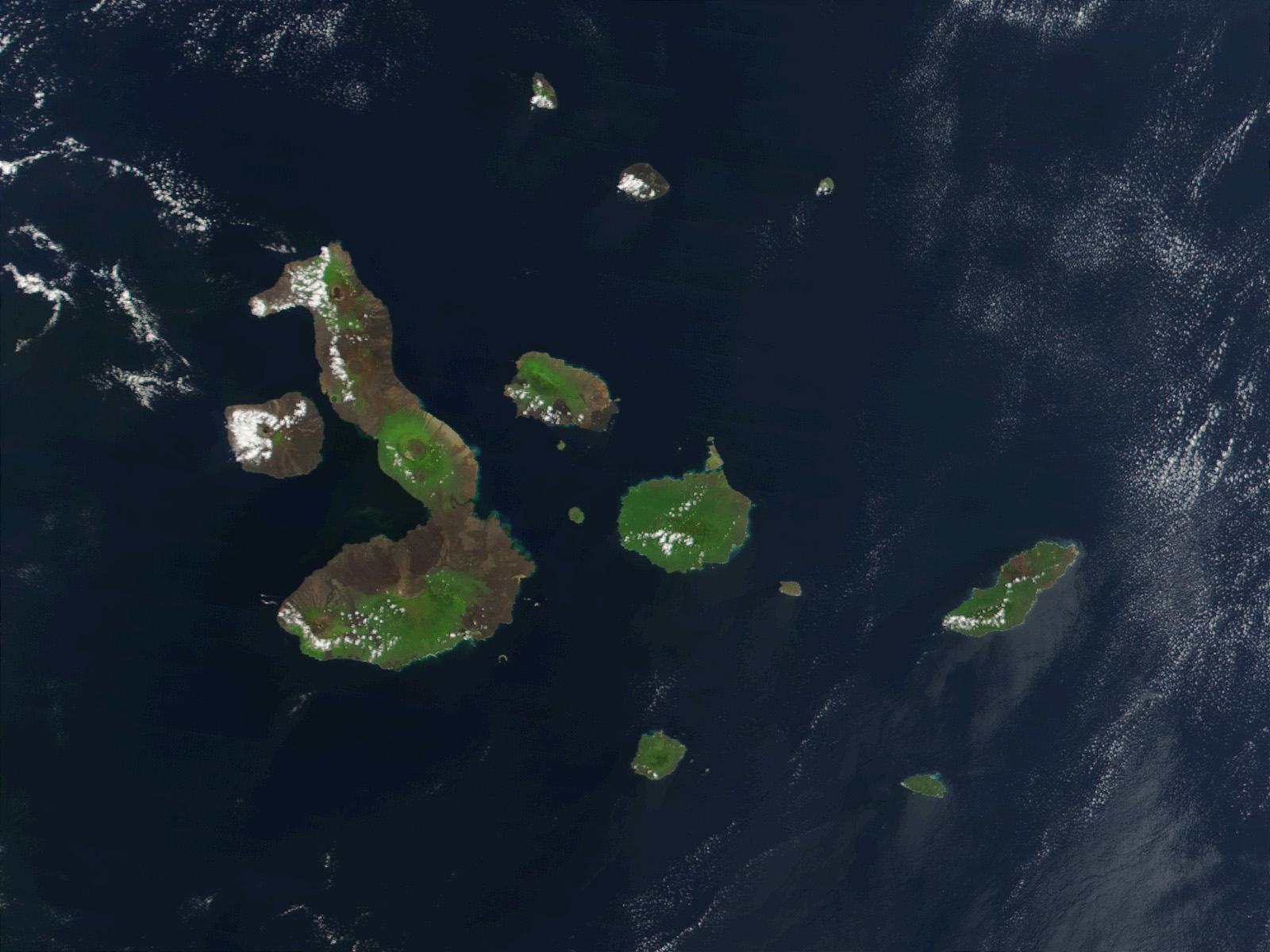
| BeskrywingGalapagos-satellite-2002.jpg |
English: This true-color image of the Galapagos Islands was acquired on March 12, 2002, by the Moderate-resolution Imaging Spectroradiometer (MODIS), flying aboard NASA's Terra satellite. The Galapagos Islands, which are part of Ecuador, sit in the Pacific Ocean about 1000 km (620 miles) west of South America. As the three craters on the largest island (Isabela Island) suggest, the archipelago was created by volcanic eruptions, which took place millions of years ago. |
| Datum | |
| Bron | Earth Observatory 8270 and NASA GSFC |
| Outeur | Jacques Descloitres, MODIS Rapid Response Project at NASA/GSFC |
Lisensiëring
| Public domainPublic domainfalsefalse |
| This file is in the public domain in the United States because it was solely created by NASA. NASA copyright policy states that "NASA material is not protected by copyright unless noted". (See Template:PD-USGov, NASA copyright policy page or JPL Image Use Policy.) | ||
 |
Warnings:
|
| Annotations InfoField | This image is annotated: View the annotations at Commons |
Pinta
Marchena
Genovesa
San Salvador (Santiago)
Rábida
Pinzón
Floreana
Fernandina
Santa Fé
San Cristóbal
Española
Santa Cruz
Isabela
Baltra (Seymour Sur)
Tortuga
Seymour Norte
Plaza Sur
Daphne Mayor
Roca Redonda
Captions
Items portrayed in this file
uitbeelding
12 Maart 2002
Lêergeskiedenis
Klik op die datum/tyd om te sien hoe die lêer destyds gelyk het.
| Datum/Tyd | Duimnael | Dimensies | Gebruiker | Opmerking | |
|---|---|---|---|---|---|
| huidig | 21:13, 25 November 2007 | | 1 600 × 1 200 (387 KG) | CarolSpears | {{Information |Description= This true-color image of the Galapagos Islands was acquired on March 12, 2002, by the Moderate-resolution Imaging Spectroradiometer (MODIS), flying aboard NASA's Terra satellite. The Galapagos Islands, which are part of Ecuador |
Lêergebruik
Die volgende 2 bladsye gebruik dié lêer:
Globale lêergebruik
Die volgende ander wiki's gebruik hierdie lêer:
- Gebruik in als.wikipedia.org
- Gebruik in an.wikipedia.org
- Gebruik in ast.wikipedia.org
- Gebruik in azb.wikipedia.org
- Gebruik in bg.wikipedia.org
- Gebruik in bn.wikipedia.org
- Gebruik in br.wikipedia.org
- Gebruik in ca.wikipedia.org
- Gebruik in cs.wikipedia.org
- Gebruik in de.wikipedia.org
- Gebruik in de.wikinews.org
- Gebruik in en.wikipedia.org
- Gebruik in en.wikivoyage.org
- Gebruik in en.wiktionary.org
- Gebruik in eo.wikipedia.org
- Gebruik in es.wikipedia.org
- Gebruik in frr.wikipedia.org
- Gebruik in fr.wikipedia.org
- Gebruik in hu.wikipedia.org
- Gebruik in hy.wikipedia.org
- Gebruik in incubator.wikimedia.org
- Gebruik in it.wikipedia.org
- Gebruik in ja.wikipedia.org
- Gebruik in jv.wikipedia.org
- Gebruik in kn.wikipedia.org
Wys meer globale gebruik van die lêer.
Metadata
Die lêer bevat aanvullende inligting wat moontlik deur 'n digitale kamera of skandeerder bygevoeg is.
As die lêer verander is, sal sekere inligting dalk nie meer ooreenkom met dié van die gewysigde lêer nie.
| _error | 0 |
|---|