This article is about the railway line from Spiez to Brig. For the railway that built it, see
Bern–Lötschberg–Simplon railway. For the railway company that currently owns it, see
BLS AG.
The Lötschberg line is a railway in Switzerland, connecting Spiez in the canton of Bern with Brig in the canton of Valais. It crosses the Bernese Alps, from the Bernese Oberland to Upper Valais, through the Lötschberg Tunnel in the middle of the line. Together with the Simplon Tunnel south of Brig, it constitutes one of the major railways through the Alps and an important north-south axis in Europe. The Lötschberg axis is backed by the lower and longer Lötschberg Base Tunnel, part of the New Railway Links through the Alps project.
Quick Facts Overview, Status ...
| Lötschberg railway line |
|---|
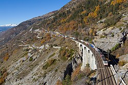 Luogelkin viaduct near Hohtenn |
|
| Status | running daily |
|---|
| Owner | BLS AG |
|---|
| Locale | Bern and Valais |
|---|
| Termini | |
|---|
| Stations | 12 |
|---|
|
| Type | Commuter and tourist railway |
|---|
| System | nationally integrated |
|---|
| Services | 1 |
|---|
| Operator(s) | BLS |
|---|
|
| Opened | 1913 |
|---|
|
| Line length | 74 km (46 mi) |
|---|
| Number of tracks | 2 |
|---|
| Rack system | None |
|---|
| Track gauge | 1,435 mm (4 ft 8+1⁄2 in) |
|---|
| Minimum radius | 300 m (980 ft) |
|---|
| Electrification | 15 kV/16.7 Hz AC overhead catenary |
|---|
| Highest elevation | 1,240 m (4,068 ft) |
|---|
| Maximum incline | 2.7% |
|---|
|
|
|
|
|
|
|
|
|
|
|
Spiez |
|
|
|
|
|
to Interlaken |
|
|
|
|
|
|
|
|
|
Hondrich tunnel I / II (1601 / 1709 m) |
|
|
|
|
|
|
|
|
2.6 |
|
|
|
|
5.2 |
Heustrich-Emdtal |
(678 m asl) |
|
|
|
6.8 |
Niesenbahn / Mülenen |
692 m asl |
|
|
|
8.3 |
Reichenbach im Kandertal |
706 m asl |
|
|
|
10.4 |
Wengi-Ey junction |
|
|
|
11.3 |
Wengi |
|
|
|
13.5 |
Frutigen |
779 m asl |
|
|
|
|
Engstlige tunnel (~2.600 m) |
|
|
|
|
Widi tunnel (~220 m) |
|
|
|
|
|
|
|
|
|
|
|
|
|
|
Tellenfeld control office |
|
|
|
|
north portal of Base Tunnel (34,577 m) |
|
|
|
|
Kander viaduct I and II (265 m) |
|
|
|
17.4 |
Kandergrund |
|
|
|
|
Bunderbach spiral tunnel (1,655 m) |
|
|
|
|
Kehrtunnel (72 m) |
|
|
|
|
Fürten I / II (697/510 m) |
|
|
|
|
Ronenwald (76 m) |
|
|
|
|
Ronenwald I (59 m) |
|
|
|
|
Ronenwald II (60 m) |
|
|
|
|
Feschfluh (98 m) |
|
|
|
|
Felsenburg (68 m) |
|
|
|
|
Felsenburg III (112 m) |
|
|
|
|
Felsenburg I (19 m) |
|
|
|
22.3 |
Blausee-Mitholz (partly closed) |
974 m asl |
|
|
|
|
Felsenburg II (29 m) |
|
|
|
27.11 |
Felsburg crossing loop (closed) |
|
|
|
|
Rotbach (50 m) |
|
|
|
|
Hemligen (106 m) |
|
|
|
|
Mitholz |
|
|
|
|
Riedschuk (1,536 m) |
|
|
|
|
|
|
|
|
|
Sarengraben (68 m) |
|
|
|
31.6 |
Kandersteg |
1,176 m asl |
|
|
|
|
 Car ferry terminal Car ferry terminal |
|
|
|
|
|
|
|
|
|
Car ferry storage sidings |
|
|
|
|
Lötschberg Tunnel (14,612 m) |
|
|
|
48.4 |
Goppenstein |
1,217 m asl |
|
|
|
|
Car ferry terminal |
|
|
|
|
Lonza (right:87 m, centre: 84 m) |
|
|
|
|
Rotlaui (286 m) |
|
|
|
|
|
|
|
|
|
Mittalgraben I (459 m) |
|
|
|
|
Luegie (493 m) |
|
|
|
|
Hohegg (118 m) |
|
|
|
|
Marchgraben (207 m) |
|
|
|
|
Mittalgraben tunnel II (1,600 m) |
|
|
|
|
Hohtenn (1,346 m) |
|
|
|
|
|
|
|
|
|
|
|
|
|
54.2 |
Hohtenn |
1,078 m asl |
|
|
|
|
Luegelkinn (116 m) |
|
|
|
|
Schluchi (107 m) |
|
|
|
|
Lidenplatten (217 m) |
|
|
|
|
Ijolibach (92 m) |
|
|
|
|
Blasboden (377 m) |
|
|
|
|
Bietschtal I (589 m) |
|
|
|
|
Bietschtal (136 m) |
|
|
|
|
Bietschtal II (952 m) |
|
|
|
|
Sevistein III (409 m) |
|
|
|
|
Mahnkinn (385 m) |
|
|
|
|
Doren (172 m) |
|
|
|
61.3 |
Ausserberg |
932 m asl |
|
|
|
|
Gründen (148 m) |
|
|
|
|
Viktoria (28 m) |
|
|
|
|
Baltschieder (101 m) |
|
|
|
|
Eggerberg (792 m) |
|
|
|
64.9 |
Eggerberg |
853 m asl |
|
|
|
|
Stadel (133 m) |
|
|
|
|
Finnengraben 69 m |
|
|
|
67.3 |
Lalden |
801 m asl |
|
|
|
|
Bad (80 m) |
|
|
|
|
Mundbach (88 m) |
|
|
|
|
Rhone bridge (83 m) |
|
|
|
|
|
|
|
|
|
|
|
|
|
73.8 |
Brig |
678 m asl |
|
|
|
|
|
|
|
|
|
Simplon Tunnel (19,803m) |
|
|
|
|
Italian–Swiss border |
|
|
|
|
|
|
|
|
|
|
|
|
|
|
|
|
|
|
|
|
|
Close
The line is famous for its double loop of spiral tunnels in the Kander Valley on its northern approach to the Lötschberg Tunnel and the climb out of the Rhone Valley along a steep mountainside through numerous tunnels and viaducts on the southern approach. Its culminating point is 1,240 metres (4,070 ft) above sea level, making it the highest adhesion and standard gauge railway in Switzerland.

