File:Yorubaland_location_map.png
From Wikipedia, the free encyclopedia
No higher resolution available.
Yorubaland_location_map.png (250 × 115 pixels, file size: 8 KB, MIME type: image/png)
| This is a file from the Wikimedia Commons. Information from its description page there is shown below. Commons is a freely licensed media file repository. You can help. |

|
This locator map image could be re-created using vector graphics as an SVG file. This has several advantages; see Commons:Media for cleanup for more information. If an SVG form of this image is available, please upload it and afterwards replace this template with
{{vector version available|new image name}}.
It is recommended to name the SVG file “Yorubaland location map.svg”—then the template Vector version available (or Vva) does not need the new image name parameter. |
Summary
| DescriptionYorubaland location map.png |
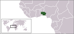
English: Location of Yorubaland
Euskara: Joruba Herriaren koakalekua erakusten duen mapa. |
| Date | (UTC) |
| Source |
This file was derived from: LocationIgboland.png |
| Author | Ukabia |
Licensing
This file is licensed under the Creative Commons Attribution-Share Alike 3.0 Unported license.
- You are free:
- to share – to copy, distribute and transmit the work
- to remix – to adapt the work
- Under the following conditions:
- attribution – You must give appropriate credit, provide a link to the license, and indicate if changes were made. You may do so in any reasonable manner, but not in any way that suggests the licensor endorses you or your use.
- share alike – If you remix, transform, or build upon the material, you must distribute your contributions under the same or compatible license as the original.
Original upload log
Transferred from en.wikipedia to Commons by Xabier Armendaritz.
The original description page was here. All following user names refer to en.wikipedia.
- 2010-08-27 17:29 Brout8 250×115× (8195 bytes) {{Information |Description = Location of yorubaland |Source = http://en.wikipedia.org/wiki/File:LocationIgboland.png |Date = ~~~~~ |Author = Ukabia |Permission = |other_versions = }}
Captions
Add a one-line explanation of what this file represents
Items portrayed in this file
depicts
27 August 2010
File history
Click on a date/time to view the file as it appeared at that time.
| Date/Time | Thumbnail | Dimensions | User | Comment | |
|---|---|---|---|---|---|
| current | 12:20, 24 October 2012 | | 250 × 115 (8 KB) | Xabier Armendaritz | {{Information |Description ={{en|1=Location of Yorubaland}} {{eu|1=Joruba Herriaren koakalekua erakusten duen mapa.}} |Source =Transferred from [http://en.wikipedia.org en.wikipedia] by User:Xabier Armendaritz. |Author =Ukabia |D... |
File usage
The following pages on the English Wikipedia use this file (pages on other projects are not listed):
Global file usage
The following other wikis use this file:
- Usage on af.wikipedia.org
- Usage on bg.wikipedia.org
- Usage on ca.wikipedia.org
- Usage on eu.wikipedia.org
- Usage on ga.wikipedia.org
- Usage on oc.wikipedia.org
- Usage on ta.wikipedia.org
- Usage on tt.wikipedia.org
- Usage on www.wikidata.org
Retrieved from "https://en.wikipedia.org/wiki/File:Yorubaland_location_map.png"