File:WindRiverBasinStructuralMap.png
From Wikipedia, the free encyclopedia
Size of this preview: 800 × 536 pixels. Other resolutions: 320 × 214 pixels | 640 × 429 pixels | 1,024 × 686 pixels | 1,161 × 778 pixels.
Original file (1,161 × 778 pixels, file size: 437 KB, MIME type: image/png)
| This is a file from the Wikimedia Commons. Information from its description page there is shown below. Commons is a freely licensed media file repository. You can help. |
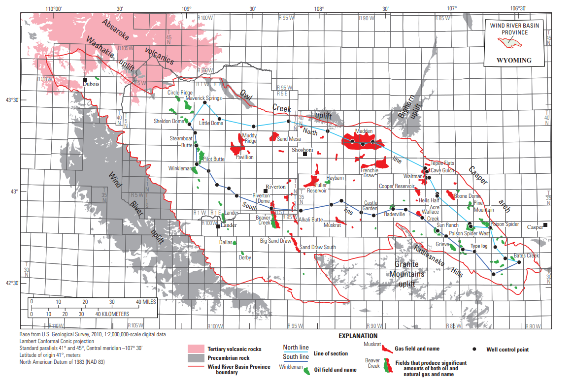
Summary
| DescriptionWindRiverBasinStructuralMap.png |
English: Wind River Basin Structural Map |
| Date | |
| Source | Stratigraphic Cross Sections of the Mowry Shale and Associated Strata in the Wind River Basin, Wyoming, USGS, https://pubs.usgs.gov/sim/3476/sim3476_pamphlet.pdf |
| Author | Thomas M. Finn |
Licensing
| Public domainPublic domainfalsefalse |
This image is in the public domain in the United States because it only contains materials that originally came from the United States Geological Survey, an agency of the United States Department of the Interior. For more information, see the official USGS copyright policy.
Bahasa Indonesia ∙ català ∙ čeština ∙ Deutsch ∙ eesti ∙ English ∙ español ∙ français ∙ galego ∙ italiano ∙ Nederlands ∙ português ∙ polski ∙ sicilianu ∙ suomi ∙ Tiếng Việt ∙ Türkçe ∙ български ∙ македонски ∙ русский ∙ മലയാളം ∙ 한국어 ∙ 日本語 ∙ 中文 ∙ 中文(简体) ∙ 中文(繁體) ∙ العربية ∙ فارسی ∙ +/− |
Captions
Wind River Basin Structural Map
Items portrayed in this file
depicts
1 January 2021
image/png
File history
Click on a date/time to view the file as it appeared at that time.
| Date/Time | Thumbnail | Dimensions | User | Comment | |
|---|---|---|---|---|---|
| current | 17:31, 20 July 2023 | | 1,161 × 778 (437 KB) | Pi3.124 | Uploaded a work by Thomas M. Finn from Stratigraphic Cross Sections of the Mowry Shale and Associated Strata in the Wind River Basin, Wyoming, USGS, https://pubs.usgs.gov/sim/3476/sim3476_pamphlet.pdf with UploadWizard |
File usage
The following pages on the English Wikipedia use this file (pages on other projects are not listed):
Metadata
This file contains additional information, probably added from the digital camera or scanner used to create or digitize it.
If the file has been modified from its original state, some details may not fully reflect the modified file.
| Horizontal resolution | 37.79 dpc |
|---|---|
| Vertical resolution | 37.79 dpc |
Retrieved from "https://en.wikipedia.org/wiki/File:WindRiverBasinStructuralMap.png"