File:TL-Vert-Land-Einw.png
From Wikipedia, the free encyclopedia
No higher resolution available.
TL-Vert-Land-Einw.png (490 × 593 pixels, file size: 39 KB, MIME type: image/png)
| This is a file from the Wikimedia Commons. Information from its description page there is shown below. Commons is a freely licensed media file repository. You can help. |
Summary
| DescriptionTL-Vert-Land-Einw.png |
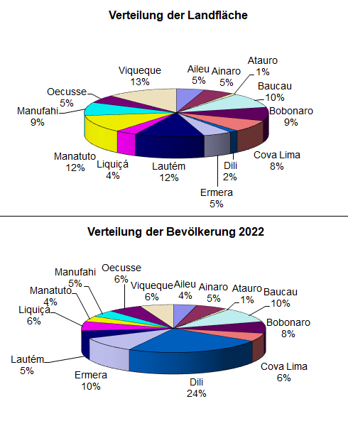
Deutsch: Prozentuale Verteilung der Landfläche und der Einwohnerzahl Osttimors auf die einzelnen Distrikte. English: allocation of land area and poplation to the districts of East Timor in percent |
| Date | (datas from 2010) |
| Source | Own work |
| Author | J. Patrick Fischer |
Licensing
| Public domainPublic domainfalsefalse |
| I, the copyright holder of this work, release this work into the public domain. This applies worldwide. In some countries this may not be legally possible; if so: I grant anyone the right to use this work for any purpose, without any conditions, unless such conditions are required by law. |
Captions
Add a one-line explanation of what this file represents
Items portrayed in this file
depicts
some value
4 November 2010
image/png
File history
Click on a date/time to view the file as it appeared at that time.
| Date/Time | Thumbnail | Dimensions | User | Comment | |
|---|---|---|---|---|---|
| current | 14:54, 18 May 2023 | | 490 × 593 (39 KB) | J. Patrick Fischer | update |
| 17:13, 8 July 2011 |  | 490 × 593 (24 KB) | J. Patrick Fischer | update area | |
| 15:39, 8 July 2011 |  | 490 × 593 (24 KB) | J. Patrick Fischer | [http://dne.mof.gov.tl/published/2010%20and%202011%20Publications/Census%20Summary%20English/English%20Census%20Summary%202011.pdf Final results 2010 census] | |
| 10:02, 4 November 2010 |  | 490 × 593 (23 KB) | J. Patrick Fischer | update 2010 | |
| 13:05, 18 July 2010 |  | 490 × 588 (18 KB) | J. Patrick Fischer | Update mit Daten und Distriktsbezeichnungen von 2008 | |
| 18:24, 20 March 2009 |  | 563 × 710 (23 KB) | J. Patrick Fischer | {{Information |Description={{de|1=Prozentuale Verteilung der Landfläche und der Einwohnerzahl Osttimors auf die einzelnen Distrikte.}} |Source=Eigenes Werk (own work) |Author=J. Patrick Fischer |Date=20.03.2009 (datas from 200 |
File usage
The following pages on the English Wikipedia use this file (pages on other projects are not listed):
Global file usage
The following other wikis use this file:
- Usage on ar.wikipedia.org
- Usage on de.wikipedia.org
- Usage on no.wikipedia.org
Metadata
This file contains additional information, probably added from the digital camera or scanner used to create or digitize it.
If the file has been modified from its original state, some details may not fully reflect the modified file.
| Short title |
|
|---|---|
| Author |
|
| Image title | |
| Horizontal resolution | 37.8 dpc |
| Vertical resolution | 37.8 dpc |
Retrieved from "https://en.wikipedia.org/wiki/File:TL-Vert-Land-Einw.png"