File:Ruvuma_River_basin_map_OSM.png
From Wikipedia, the free encyclopedia
Size of this preview: 780 × 600 pixels. Other resolutions: 312 × 240 pixels | 624 × 480 pixels | 999 × 768 pixels | 1,280 × 985 pixels | 2,560 × 1,969 pixels | 4,606 × 3,543 pixels.
Original file (4,606 × 3,543 pixels, file size: 23.21 MB, MIME type: image/png)
| This is a file from the Wikimedia Commons. Information from its description page there is shown below. Commons is a freely licensed media file repository. You can help. |
Summary
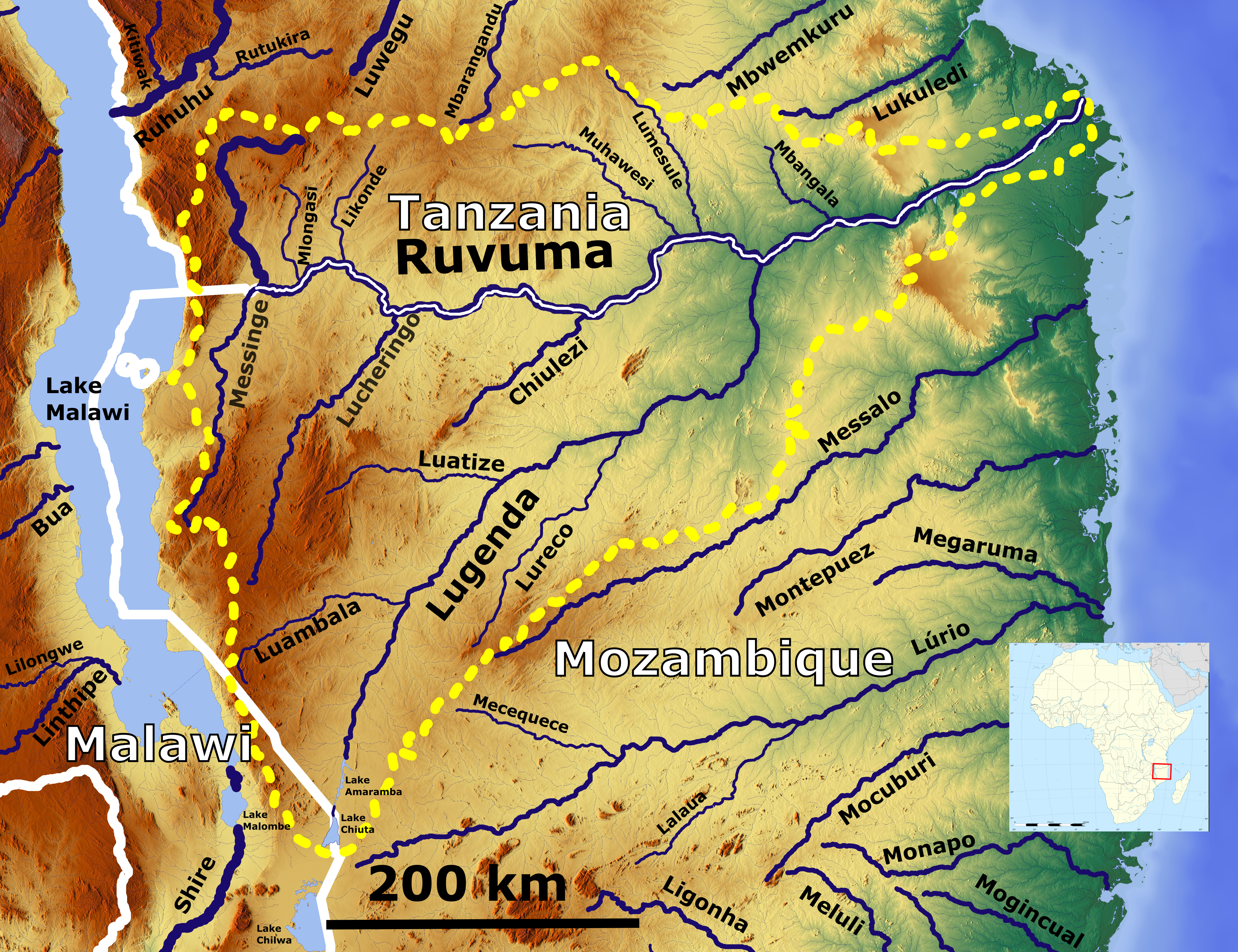
| DescriptionRuvuma River basin map OSM.png | Map of the Ruvuma River drainage basin_OSM. Based on US military map sd37 |
| Date | |
| Source | https://maps-for-free.com, http://legacy.lib.utexas.edu/maps/ams/africa_1m/, Location map:File:Africa location map.svg |
| Author | Hans Braxmeier & Peter in s, Location map:Sting |
This file is licensed under the Creative Commons Attribution-Share Alike 3.0 Unported license.
- You are free:
- to share – to copy, distribute and transmit the work
- to remix – to adapt the work
- Under the following conditions:
- attribution – You must give appropriate credit, provide a link to the license, and indicate if changes were made. You may do so in any reasonable manner, but not in any way that suggests the licensor endorses you or your use.
- share alike – If you remix, transform, or build upon the material, you must distribute your contributions under the same or compatible license as the original.
Captions
Add a one-line explanation of what this file represents
Items portrayed in this file
depicts
4 December 2020
image/png
94c6a88a48e50e93ad7e353fdccaf567c6c427c7
24,335,919 byte
3,543 pixel
4,606 pixel
File history
Click on a date/time to view the file as it appeared at that time.
| Date/Time | Thumbnail | Dimensions | User | Comment | |
|---|---|---|---|---|---|
| current | 09:07, 4 December 2020 | | 4,606 × 3,543 (23.21 MB) | Peter in s | {{Information |Description= Map of the Ruvuma River drainage basin_OSM. Based on US military map sd37 |Source= https://maps-for-free.com, http://legacy.lib.utexas.edu/maps/ams/africa_1m/ |Date= 2020-12-04 |Author= Hans Braxmeier & Peter in s |other_versions= }} {{cc-by-sa-2.0}} Category:Ruvuma River Category:Maps of rivers in Tanzania Category:Drainage basin maps of Africa Category:Maps of rivers of Mozambique |
File usage
The following pages on the English Wikipedia use this file (pages on other projects are not listed):
Global file usage
The following other wikis use this file:
- Usage on af.wikipedia.org
- Usage on ar.wikipedia.org
- Usage on be.wikipedia.org
- Usage on bg.wikipedia.org
- Usage on ca.wikipedia.org
- Usage on ceb.wikipedia.org
- Usage on cs.wikipedia.org
- Usage on de.wikipedia.org
- Usage on el.wikipedia.org
- Usage on eo.wikipedia.org
- Usage on es.wikipedia.org
- Usage on eu.wikipedia.org
- Usage on fa.wikipedia.org
- Usage on fi.wikipedia.org
- Usage on gl.wikipedia.org
- Usage on ha.wikipedia.org
- Usage on pl.wikipedia.org
- Usage on pt.wikipedia.org
- Usage on www.wikidata.org
- Usage on zh.wikipedia.org
Metadata
This file contains additional information, probably added from the digital camera or scanner used to create or digitize it.
If the file has been modified from its original state, some details may not fully reflect the modified file.
| Horizontal resolution | 35.43 dpc |
|---|---|
| Vertical resolution | 35.43 dpc |
| Software used |
Retrieved from "https://en.wikipedia.org/wiki/File:Ruvuma_River_basin_map_OSM.png"