File:Rheinbund_1808,_political_map.png
From Wikipedia, the free encyclopedia
Size of this preview: 507 × 599 pixels. Other resolutions: 203 × 240 pixels | 406 × 480 pixels | 650 × 768 pixels | 866 × 1,024 pixels | 2,413 × 2,852 pixels.
Original file (2,413 × 2,852 pixels, file size: 1.6 MB, MIME type: image/png)
| This is a file from the Wikimedia Commons. Information from its description page there is shown below. Commons is a freely licensed media file repository. You can help. |
Summary
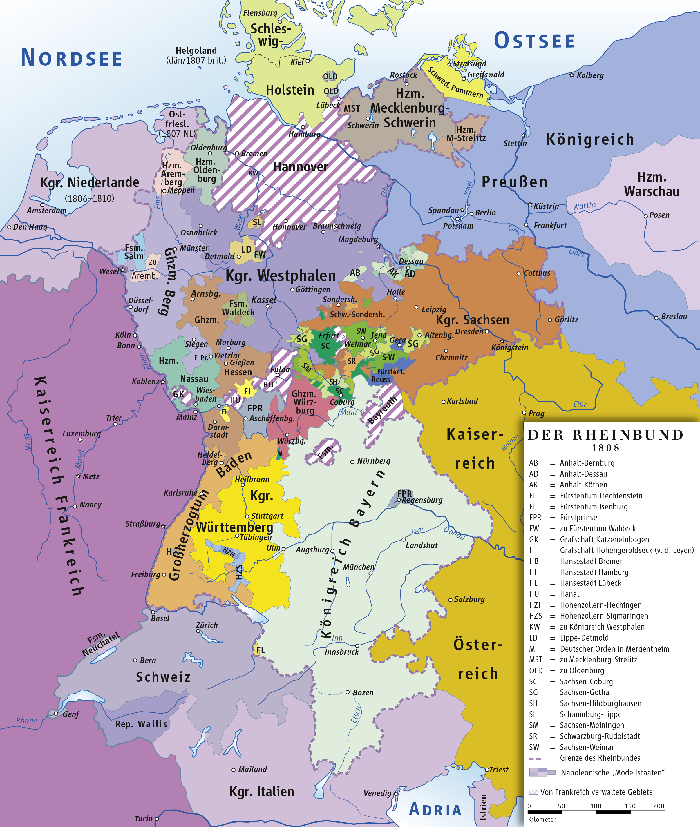
| DescriptionRheinbund 1808, political map.png | Karte des Rheinbundes 1808/Map of Confederation of the Rhine 1808 |
| Date | |
| Source | own drawing/Source of Information: Putzger – Historischer Weltatlas, 89. Auflage, 1965; Westermanns Großer Atlas zur Weltgeschichte, 1969; Haacks geographischer Atlas. VEB Hermann Haack Geographisch-Kartographische Anstalt, Gotha/Leipzig, 1. Auflage, 1979. |
| Author | ziegelbrenner |
| Permission (Reusing this file) |
GNU FDL |
Licensing
I, the copyright holder of this work, hereby publish it under the following licenses:

|
Permission is granted to copy, distribute and/or modify this document under the terms of the GNU Free Documentation License, Version 1.2 or any later version published by the Free Software Foundation; with no Invariant Sections, no Front-Cover Texts, and no Back-Cover Texts. A copy of the license is included in the section entitled GNU Free Documentation License.http://www.gnu.org/copyleft/fdl.htmlGFDLGNU Free Documentation Licensetruetrue |
| This file is licensed under the Creative Commons Attribution-Share Alike 3.0 Unported license. | ||
| ||
| This licensing tag was added to this file as part of the GFDL licensing update.http://creativecommons.org/licenses/by-sa/3.0/CC BY-SA 3.0Creative Commons Attribution-Share Alike 3.0truetrue |
This file is licensed under the Creative Commons Attribution 2.5 Generic license.
- You are free:
- to share – to copy, distribute and transmit the work
- to remix – to adapt the work
- Under the following conditions:
- attribution – You must give appropriate credit, provide a link to the license, and indicate if changes were made. You may do so in any reasonable manner, but not in any way that suggests the licensor endorses you or your use.
You may select the license of your choice.
Captions
Add a one-line explanation of what this file represents
Items portrayed in this file
depicts
7 February 2007
File history
Click on a date/time to view the file as it appeared at that time.
| Date/Time | Thumbnail | Dimensions | User | Comment | |
|---|---|---|---|---|---|
| current | 17:59, 9 November 2022 | | 2,413 × 2,852 (1.6 MB) | Ziegelbrenner | some corrctions |
| 17:52, 9 November 2022 |  | 2,413 × 2,852 (1.45 MB) | Ziegelbrenner | Fürstprimas | |
| 11:50, 14 February 2014 |  | 1,998 × 2,361 (1.17 MB) | Ziegelbrenner | 2014-02-14 | |
| 10:32, 3 February 2014 |  | 1,999 × 2,362 (2.04 MB) | Ziegelbrenner | 2014-02-03 | |
| 13:28, 31 January 2014 |  | 508 × 600 (194 KB) | Ziegelbrenner | Reverted to version as of 16:05, 20 January 2014 Why did you revert this? New version has some corrections. | |
| 16:13, 30 January 2014 |  | 1,772 × 2,094 (926 KB) | Эрманарих | Reverted to version as of 14:03, 17 January 2013 | |
| 16:05, 20 January 2014 |  | 508 × 600 (194 KB) | Ziegelbrenner | 2014-01-20 | |
| 14:03, 17 January 2013 |  | 1,772 × 2,094 (926 KB) | Ziegelbrenner | 2013-01-17 | |
| 14:54, 3 February 2011 |  | 2,008 × 2,362 (1.92 MB) | Ziegelbrenner | 2011-02-03 | |
| 10:42, 3 February 2011 |  | 2,008 × 2,362 (4 MB) | Ziegelbrenner | 2011-02-03 |
File usage
The following pages on the English Wikipedia use this file (pages on other projects are not listed):
Global file usage
The following other wikis use this file:
- Usage on ast.wikipedia.org
- Usage on azb.wikipedia.org
- Usage on be.wikipedia.org
- Usage on bg.wikipedia.org
- Usage on br.wikipedia.org
- Usage on cs.wikipedia.org
- Rýnský spolek
- Bavorské království
- Frankfurtské velkovévodství
- Aschaffenburské knížectví
- Sasko-výmarsko-eisenašské vévodství
- Bádenské velkovévodství
- Hesenské velkovévodství
- Württemberské království
- Saské království
- Šablona:Členské státy Rýnského spolku
- Vestfálské království
- Würzburské velkovévodství
- Salmové (Pustinná a porýnská hrabata)
- Usage on cv.wikipedia.org
- Usage on da.wikipedia.org
- Usage on de.wikipedia.org
- 1808
- Friedrich Wilhelm III. (Preußen)
- Rheinbund
- Königreich Westphalen
- Großherzogtum Berg
- Großherzogtum Würzburg
- Pauline (Lippe)
- Mettingen
- Geschichte der Stadt Duisburg
- Fürstentum Salm
- Lindau (Eichsfeld)
- Tiroler Volksaufstand
- Benutzer:TravenTorsvan/Baustelle/Babel
- Benutzer:TravenTorsvan/Vorlage/Geschichte:Rheinbund: Karte des Rheinbundes 1808
- Geschichte Nordrhein-Westfalens
- Wahlrecht in den deutschen Einzelstaaten bis 1918
- Benutzer:Ziegelbrenner/Meine Bilder auf Commons
- Liste der Mitgliedstaaten im Rheinbund
- Geschichte der Stadt Soltau
- Benutzer:Palatinus SP
- Johann Georg Wagner (Jurist)
- Benutzer:Aurdi
- Geschichte von Lindau (Eichsfeld)
- Usage on el.wikipedia.org
- Usage on es.wikipedia.org
View more global usage of this file.
Metadata
This file contains additional information, probably added from the digital camera or scanner used to create or digitize it.
If the file has been modified from its original state, some details may not fully reflect the modified file.
| Short title |
|
|---|---|
| Software used | Adobe Illustrator 26.5 (Macintosh) |
| Date and time of digitizing | 19:58, 9 November 2022 |
| File change date and time | 19:58, 9 November 2022 |
| Date metadata was last modified | 19:58, 9 November 2022 |
| Unique ID of original document | uuid:80696F872CD611DDAF2586899003A8DB |
| Horizontal resolution | 118.11 dpc |
| Vertical resolution | 118.11 dpc |
Retrieved from "https://en.wikipedia.org/wiki/File:Rheinbund_1808,_political_map.png"