File:Regional_parks_in_Perth,_Western_Australia.jpg
From Wikipedia, the free encyclopedia
Regional_parks_in_Perth,_Western_Australia.jpg (285 × 349 pixels, file size: 89 KB, MIME type: image/jpeg)
Summary
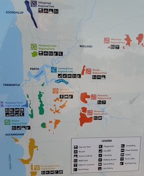
[edit]| Description | A map of the Regional parks in Perth, Western Australia, taken from an information board at the start of Mount Brown walk, Beeliar Regional Park. |
|---|---|
| Author or copyright owner |
Parks and Wildlife Service |
| Source (WP:NFCC#4) | Original publication: On information board Immediate source: Information board |
| Date of publication | 2021 |
| Use in article (WP:NFCC#7) | Regional parks in Western Australia |
| Purpose of use in article (WP:NFCC#8) | To illustrate the layout of Regional parks in Perth, Western Australia |
| Not replaceable with free media because (WP:NFCC#1) |
No free source found that adequately shows all regional parks |
| Minimal use (WP:NFCC#3) | Only used on the one overall article. |
| Respect for commercial opportunities (WP:NFCC#2) |
The Parks and Wildlife Service publishes this map to attract people to visit the parks, showing it here will only improve this effort. |
| Fair useFair use of copyrighted material in the context of Regional parks in Western Australia//en.wikipedia.org/wiki/File:Regional_parks_in_Perth,_Western_Australia.jpgtrue | |
Licensing
[edit] | This image represents a two-dimensional work of art, such as a drawing, painting, print, or similar creation. The copyright for this image is likely owned by either the artist who created it, the individual who commissioned the work, or their legal heirs. It is believed that the use of low-resolution images of artworks:
qualifies as fair use under United States copyright law. Any other use of this image, whether on Wikipedia or elsewhere, could potentially constitute a copyright infringement. For further information, please refer to Wikipedia's guidelines on non-free content. | ||
| |||
File history
Click on a date/time to view the file as it appeared at that time.
| Date/Time | Thumbnail | Dimensions | User | Comment | |
|---|---|---|---|---|---|
| current | 00:05, 11 June 2021 | | 285 × 349 (89 KB) | DatBot (talk | contribs) | Reduce size of non-free image (BOT - disable) |
| 05:19, 10 June 2021 | No thumbnail | 2,934 × 3,591 (1.39 MB) | Calistemon (talk | contribs) | Uploading a non-free file using File Upload Wizard |
You cannot overwrite this file.
File usage
Metadata
This file contains additional information, probably added from the digital camera or scanner used to create or digitize it.
If the file has been modified from its original state, some details may not fully reflect the modified file.
| Camera manufacturer | samsung |
|---|---|
| Camera model | SM-A305YN |
| Exposure time | 1/563 sec (0.0017761989342806) |
| F-number | f/1.7 |
| ISO speed rating | 100 |
| Date and time of data generation | 08:51, 21 May 2021 |
| Lens focal length | 3.92 mm |
| Latitude | 32° 11′ 12.65″ S |
| Longitude | 115° 47′ 4.92″ E |
| Altitude | 0 meters above sea level |
| Width | 4,608 px |
| Height | 3,456 px |
| Orientation | Normal |
| Horizontal resolution | 72 dpi |
| Vertical resolution | 72 dpi |
| Software used | Windows Photo Editor 10.0.10011.16384 |
| File change date and time | 13:11, 10 June 2021 |
| Y and C positioning | Centered |
| Exposure Program | Normal program |
| Exif version | 2.2 |
| Date and time of digitizing | 08:51, 21 May 2021 |
| Meaning of each component |
|
| Shutter speed | 9.13 |
| APEX aperture | 1.53 |
| APEX brightness | 6.9 |
| Exposure bias | 0 |
| Maximum land aperture | 2.27 APEX (f/2.2) |
| Metering mode | Center weighted average |
| Flash | Flash did not fire |
| DateTime subseconds | 0122 |
| DateTimeOriginal subseconds | 0122 |
| DateTimeDigitized subseconds | 0122 |
| Supported Flashpix version | 1 |
| Color space | sRGB |
| Scene type | A directly photographed image |
| Custom image processing | Normal process |
| Exposure mode | Auto exposure |
| White balance | Auto white balance |
| Focal length in 35 mm film | 26 mm |
| Scene capture type | Standard |
| Contrast | Normal |
| Saturation | Normal |
| Sharpness | Normal |
| Unique image ID | F16LLLJ00CM |
| GPS time (atomic clock) | 00:51 |
| GPS date | 21 May 2021 |
| GPS tag version | 2.2.0.0 |