File:Prusy_historyczne.png
From Wikipedia, the free encyclopedia
No higher resolution available.
Prusy_historyczne.png (613 × 459 pixels, file size: 51 KB, MIME type: image/png)
| This is a file from the Wikimedia Commons. Information from its description page there is shown below. Commons is a freely licensed media file repository. You can help. |
Summary
| DescriptionPrusy historyczne.png |
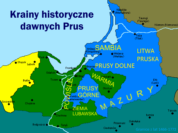
English: Map of historical lands and regions in Prussia: Warmia (Ermland), Mazury (Mazuria), Prusy Górne (Oberland), Prusy Dolne, Powiśle, Lubawa region, Sambia, Litwa Pruska (Lithuania Minor).
Polski: Mapa krain i regionów historycznych na terenie dawnych Prus, na tle granic podziału Prus w latach 1466-1772: Warmia, Mazury, Prusy Górne, Prusy Dolne, Powiśle, Ziemia Lubawska, Sambia, Litwa Pruska |
|||
| Date | 07.09.2008 | |||
| Source | Own work, na podstawie: Marian Biskup "Szkice z dziejów Pomorza", t. 1, Warszawa 1958 oraz M. Biskup, G. Labuda "Dzieje Zakonu Krzyżackiego w Prusach", Gdańsk 1986 (mapa na str. 439) | |||
| Author | Popik | |||
| Permission (Reusing this file) |
|
Captions
Add a one-line explanation of what this file represents
Items portrayed in this file
depicts
image/png
File history
Click on a date/time to view the file as it appeared at that time.
| Date/Time | Thumbnail | Dimensions | User | Comment | |
|---|---|---|---|---|---|
| current | 18:26, 30 November 2016 | | 613 × 459 (51 KB) | Popik | Reverted to version as of 14:54, 30 November 2016 (UTC) |
| 16:20, 30 November 2016 |  | 613 × 459 (52 KB) | Popik | Reverted to version as of 14:44, 30 November 2016 (UTC) | |
| 14:54, 30 November 2016 |  | 613 × 459 (51 KB) | Popik | Poprawiona wersja z Litwą Pruską (Mniejszą) | |
| 14:44, 30 November 2016 |  | 613 × 459 (52 KB) | Popik | Uzupełnienie o Litwę Pruską (Litwę Mniejszą), której zabrakło w poprzednich wersjach. | |
| 17:21, 3 August 2014 |  | 613 × 459 (62 KB) | Popik | Uzupełnienie o Prusy Dolne, których zabrakło w poprzedniej wersji | |
| 09:51, 7 September 2008 |  | 613 × 459 (87 KB) | Popik | {{Information |Description={{en|1=Map of historical lands and regions in Prussia: Warmia, Mazury, Prusy Górne, Powiśle, Lubawa region, Sambia.}} {{pl|1=Mapa krain i regionów historycznych na terenie dawnych Prus, na tle granic podziału Prus w latach 1 |
File usage
The following pages on the English Wikipedia use this file (pages on other projects are not listed):
Global file usage
The following other wikis use this file:
- Usage on be.wikipedia.org
- Usage on cs.wikipedia.org
- Usage on da.wikipedia.org
- Usage on de.wikipedia.org
- Usage on el.wikipedia.org
- Usage on eo.wikipedia.org
- Usage on es.wikipedia.org
- Usage on eu.wikipedia.org
- Usage on gl.wikipedia.org
- Usage on ja.wikipedia.org
- Usage on ka.wikipedia.org
- Usage on pl.wikipedia.org
- Usage on pl.wikiquote.org
- Usage on sl.wikipedia.org
- Usage on uk.wikipedia.org
- Usage on www.wikidata.org
- Usage on zh.wikipedia.org
Metadata
This file contains additional information, probably added from the digital camera or scanner used to create or digitize it.
If the file has been modified from its original state, some details may not fully reflect the modified file.
| Horizontal resolution | 37.8 dpc |
|---|---|
| Vertical resolution | 37.8 dpc |
Retrieved from "https://en.wikipedia.org/wiki/File:Prusy_historyczne.png"