File:Missouri_BSA_Councils.png
From Wikipedia, the free encyclopedia
Size of this preview: 600 × 600 pixels. Other resolutions: 240 × 240 pixels | 480 × 480 pixels | 900 × 900 pixels.
Original file (900 × 900 pixels, file size: 86 KB, MIME type: image/png)
| This is a file from the Wikimedia Commons. Information from its description page there is shown below. Commons is a freely licensed media file repository. You can help. |
Summary
| DescriptionMissouri BSA Councils.png |
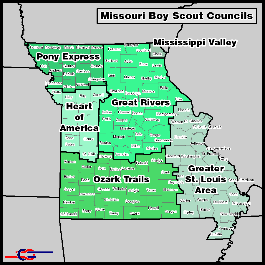
English: Missouri BSA Councils - Map created using boundary information publicized by the relevant BSA councils. US Census TIGER data used for county and state lines. Council divisions are exact where they coincide with county lines and approximate in other areas. All councils on this map are in the central region. |
| Date | 11 January 2013 (original upload date) |
| Source | Ruarkr.2008 |
| Author | Ruarkr.2008 |
| Other versions | https://sites.google.com/site/ruarkster/central-region-maps |
Licensing
Ruarkr.2008 at English Wikipedia, the copyright holder of this work, hereby publishes it under the following license:
This file is licensed under the Creative Commons Attribution 3.0 Unported license.
Attribution: Ruarkr.2008 at English Wikipedia
- You are free:
- to share – to copy, distribute and transmit the work
- to remix – to adapt the work
- Under the following conditions:
- attribution – You must give appropriate credit, provide a link to the license, and indicate if changes were made. You may do so in any reasonable manner, but not in any way that suggests the licensor endorses you or your use.
Original upload log
Transferred from en.wikipedia to Commons by Evrik using CommonsHelper.
The original description page was here. All following user names refer to en.wikipedia.
- 2013-01-11 06:33 Ruarkr.2008 900×900× (88345 bytes) Map created using boundary information publicized by the relevant BSA councils. US Census TIGER data used for county and state lines. Council divisions are exact where they coincide with county lines and approximate in other areas. All councils on this...
Captions
Add a one-line explanation of what this file represents
Items portrayed in this file
depicts
File history
Click on a date/time to view the file as it appeared at that time.
| Date/Time | Thumbnail | Dimensions | User | Comment | |
|---|---|---|---|---|---|
| current | 15:11, 5 February 2013 | | 900 × 900 (86 KB) | File Upload Bot (Magnus Manske) | Transfered from en.wikipedia by User:evrik using CommonsHelper |
File usage
The following pages on the English Wikipedia use this file (pages on other projects are not listed):
Global file usage
The following other wikis use this file:
- Usage on www.wikidata.org
Metadata
This file contains additional information, probably added from the digital camera or scanner used to create or digitize it.
If the file has been modified from its original state, some details may not fully reflect the modified file.
| Horizontal resolution | 59.06 dpc |
|---|---|
| Vertical resolution | 59.06 dpc |
Retrieved from "https://en.wikipedia.org/wiki/File:Missouri_BSA_Councils.png"