File:MedicineLkHighlands09272017-50.tif
From Wikipedia, the free encyclopedia

Size of this PNG preview of this TIF file: 800 × 427 pixels. Other resolutions: 320 × 171 pixels | 640 × 342 pixels | 1,024 × 547 pixels | 1,916 × 1,023 pixels.
Original file (1,916 × 1,023 pixels, file size: 7.48 MB, MIME type: image/tiff)
| This is a file from the Wikimedia Commons. Information from its description page there is shown below. Commons is a freely licensed media file repository. You can help. |
Summary
| DescriptionMedicineLkHighlands09272017-50.tif |
English: Medicine Lake Volcano, California, September 27, 2017, Sentinel-2 true-color satellite image, scale 1:50,000. |
| Date | |
| Source |
Own work. Sentinel-2 satellite data source: https://glovis.usgs.gov/ https://lta.cr.usgs.gov/sentinel_2 Satellite image is underlain by slope map, derived from GTOPO30 digital elevation model, source https://earthexplorer.usgs.gov/ |
| Author | Erthygy |
| Camera location | 41° 33′ 00″ N, 121° 36′ 00″ W | View this and other nearby images on: OpenStreetMap |
|---|
Licensing
I, the copyright holder of this work, hereby publish it under the following license:
This file is licensed under the Creative Commons Attribution-Share Alike 4.0 International license.
- You are free:
- to share – to copy, distribute and transmit the work
- to remix – to adapt the work
- Under the following conditions:
- attribution – You must give appropriate credit, provide a link to the license, and indicate if changes were made. You may do so in any reasonable manner, but not in any way that suggests the licensor endorses you or your use.
- share alike – If you remix, transform, or build upon the material, you must distribute your contributions under the same or compatible license as the original.
Captions
Add a one-line explanation of what this file represents
Items portrayed in this file
depicts
some value
27 September 2017
41°33'0"N, 121°36'0"W
File history
Click on a date/time to view the file as it appeared at that time.
| Date/Time | Thumbnail | Dimensions | User | Comment | |
|---|---|---|---|---|---|
| current | 09:09, 18 February 2018 | 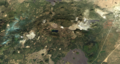 | 1,916 × 1,023 (7.48 MB) | Erthygy | User created page with UploadWizard |
File usage
The following pages on the English Wikipedia use this file (pages on other projects are not listed):
Metadata
This file contains additional information, probably added from the digital camera or scanner used to create or digitize it.
If the file has been modified from its original state, some details may not fully reflect the modified file.
| Width | 1,916 px |
|---|---|
| Height | 1,023 px |
| Compression scheme | Uncompressed |
| Pixel composition | RGB |
| Image data location | 8 |
| Number of components | 4 |
| Bytes per compressed strip | 7,840,272 |
| Horizontal resolution | 96 dpi |
| Vertical resolution | 96 dpi |
| Data arrangement | chunky format |