File:Map_Kingdom_Arelat_EN.png
From Wikipedia, the free encyclopedia
Size of this preview: 587 × 600 pixels. Other resolutions: 235 × 240 pixels | 470 × 480 pixels | 752 × 768 pixels | 1,003 × 1,024 pixels | 1,310 × 1,338 pixels.
Original file (1,310 × 1,338 pixels, file size: 209 KB, MIME type: image/png)
| This is a file from the Wikimedia Commons. Information from its description page there is shown below. Commons is a freely licensed media file repository. You can help. |
Summary
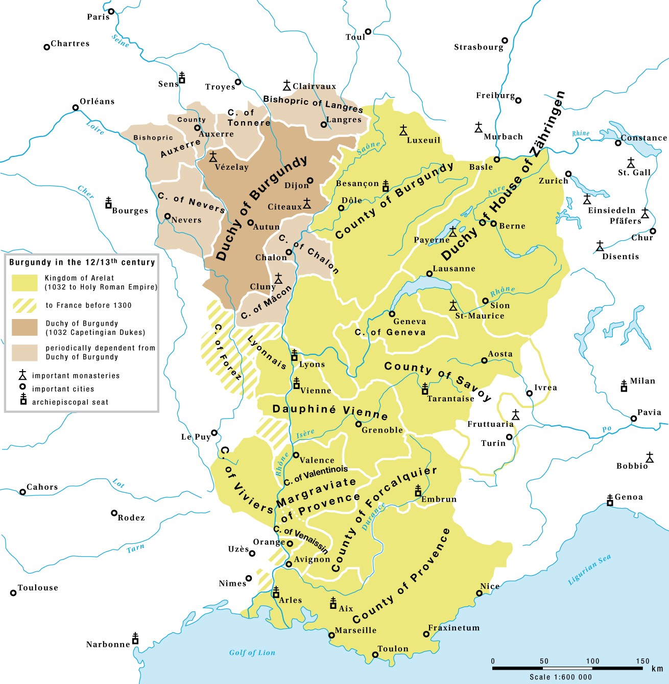
| DescriptionMap Kingdom Arelat EN.png |
English: The Kingdom of Arelat and the Capetian Duchy of Burgundy in the 12/13th century |
| Date | |
| Source | Own work |
| Author | Marco Zanoli (Sidonius) |
| Other versions |
|


Licensing
You may use my work outside wikipedia for free as long as you name me as the author. If you would like to use my work in a print medium, please send me a specimen copy.
Contact me if you have questions regarding the license or if you want individual changes to the map (marco.zanoli at hotmail.ch). This file is licensed under the Creative Commons Attribution-Share Alike 4.0 International license. Attribution: Marco Zanoli
|
Captions
Add a one-line explanation of what this file represents
Items portrayed in this file
depicts
12 February 2009
File history
Click on a date/time to view the file as it appeared at that time.
| Date/Time | Thumbnail | Dimensions | User | Comment | |
|---|---|---|---|---|---|
| current | 04:58, 4 July 2010 | | 1,310 × 1,338 (209 KB) | DcoetzeeBot | Remove watermark, add author and license data to image metadata, decrease filesize with pngcrush |
| 17:30, 15 February 2009 |  | 1,310 × 1,338 (379 KB) | Sidonius | territories to france before 1300, margraviate provence | |
| 14:51, 15 February 2009 |  | 1,310 × 1,338 (378 KB) | Sidonius | small corrections, Duchy of House of Zähringen | |
| 16:34, 13 February 2009 |  | 1,310 × 1,338 (351 KB) | Sidonius | == Beschreibung == {{Information |Description={{en|The Kingdom of Arelat and the Capetingian Duchy of Burgundy in the 12/13th century}} |Source=Eigenes Werk (own work) |Author=Marco Zanoli (Sidonius) |Date=12.2.2009 |Permission= |other_v |
File usage
The following pages on the English Wikipedia use this file (pages on other projects are not listed):
Global file usage
The following other wikis use this file:
- Usage on ar.wikipedia.org
- Usage on be.wikipedia.org
- Usage on bg.wikipedia.org
- Usage on cs.wikipedia.org
- Usage on de.wikipedia.org
- Usage on el.wikipedia.org
- Usage on es.wikipedia.org
- Usage on et.wikipedia.org
- Usage on eu.wikipedia.org
- Usage on fa.wikipedia.org
- Usage on fr.wikipedia.org
- Usage on he.wikipedia.org
- Usage on id.wikipedia.org
- Usage on it.wikipedia.org
- Usage on ja.wikipedia.org
- Usage on lt.wikipedia.org
- Usage on nl.wikipedia.org
- Usage on pl.wikipedia.org
- Usage on ro.wikipedia.org
- Usage on ru.wikipedia.org
- Usage on sh.wikipedia.org
- Usage on sl.wikipedia.org
- Usage on sr.wikipedia.org
View more global usage of this file.
Retrieved from "https://en.wikipedia.org/wiki/File:Map_Kingdom_Arelat_EN.png"