File:MSP_Airport_Diagram.pdf
From Wikipedia, the free encyclopedia
Size of this JPG preview of this PDF file: 390 × 599 pixels. Other resolutions: 156 × 240 pixels | 313 × 480 pixels | 806 × 1,237 pixels.
Original file (806 × 1,237 pixels, file size: 351 KB, MIME type: application/pdf)
| This is a file from the Wikimedia Commons. Information from its description page there is shown below. Commons is a freely licensed media file repository. You can help. |
Summary
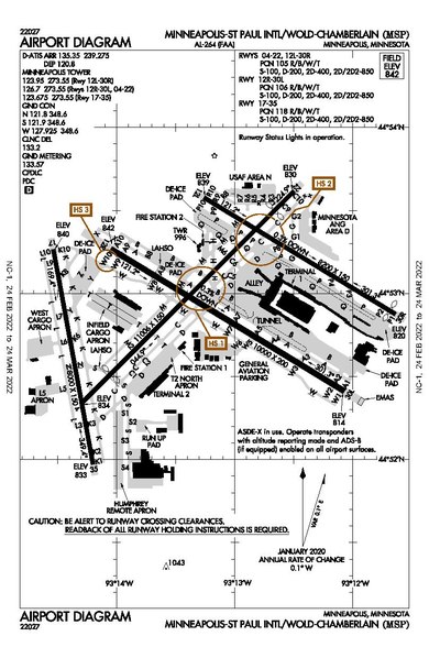
| DescriptionMSP Airport Diagram.pdf |
English: Diagram of MSP Airport |
| Date | |
| Source | faa.gov/air_traffic/flight_info/aeronav/digital_products/dtpp/search/results/ |
| Author | Federal Aviation Administration |
Licensing
| Public domainPublic domainfalsefalse |
This image or file is a work of a Federal Aviation Administration employee, taken or made as part of that person's official duties. As a work of the U.S. federal government, the image is in the public domain in the United States.
English | italiano | македонски | മലയാളം | Nederlands | русский | sicilianu | українська | 中文 | +/− |
 |
Captions
Airport Diagram of MSP Airport
Items portrayed in this file
depicts
30 January 2020
application/pdf
File history
Click on a date/time to view the file as it appeared at that time.
| Date/Time | Thumbnail | Dimensions | User | Comment | |
|---|---|---|---|---|---|
| current | 18:13, 12 March 2022 |  | 806 × 1,237 (351 KB) | Randoperson1 | Higher Quality |
| 19:19, 18 February 2020 |  | 806 × 1,237 (328 KB) | Sam.gov | User created page with UploadWizard |
File usage
The following pages on the English Wikipedia use this file (pages on other projects are not listed):
Global file usage
The following other wikis use this file:
- Usage on af.wikipedia.org
- Usage on bn.wikipedia.org
- Usage on es.wikipedia.org
- Usage on he.wikipedia.org
- Usage on simple.wikipedia.org
Metadata
This file contains additional information, probably added from the digital camera or scanner used to create or digitize it.
If the file has been modified from its original state, some details may not fully reflect the modified file.
| Short title |
|
|---|---|
| Image title | |
| Author | |
| File change date and time | 03:33, 20 January 2022 |
| Date and time of digitizing | 03:33, 20 January 2022 |
| Date metadata was last modified | 03:33, 20 January 2022 |
| Software used | OpenCities Map Ultimate 10.7.0.62 by Bentley Systems, Incorporated |
| Conversion program | Aspose.PDF for .NET 19.11 |
| Encrypted | no |
| Page size | 387.36 x 594 pts |
| Version of PDF format | 1.4 |
Retrieved from "https://en.wikipedia.org/wiki/File:MSP_Airport_Diagram.pdf"