File:Ledbury_station_-_geograph.org.uk_-_947697.jpg
From Wikipedia, the free encyclopedia
No higher resolution available.
Ledbury_station_-_geograph.org.uk_-_947697.jpg (640 × 480 pixels, file size: 97 KB, MIME type: image/jpeg)
| This is a file from the Wikimedia Commons. Information from its description page there is shown below. Commons is a freely licensed media file repository. You can help. |
Summary
| DescriptionLedbury station - geograph.org.uk - 947697.jpg |
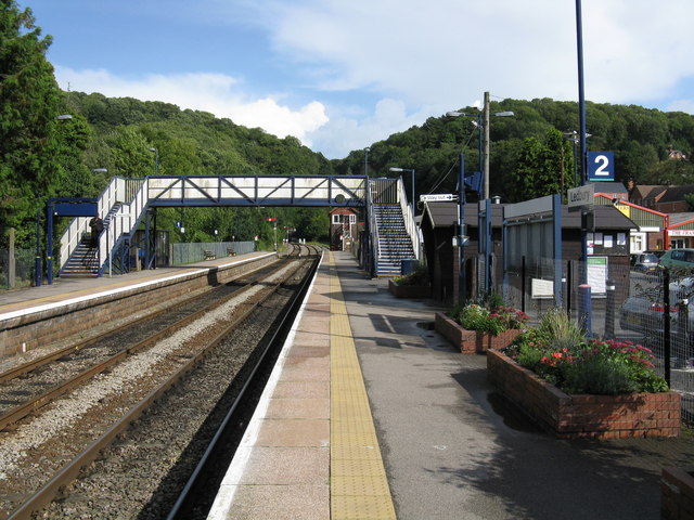
English: Ledbury station The only passing point between Malvern Wells and Shelwick Junction, near Hereford, Ledbury station has received much community attention. In consequence, flower tubs thrive, paintwork is well-maintained and TV screen information systems are provided. Another example of community pressure is the large garden shed visible on the right: the part-time booking office! Railway conoisseurs will note the original steam-era footbridge, complete with holes in the right-most section to enable the signalman to see the signals once situated just behind the photographer. |
| Date | |
| Source | From geograph.org.uk |
| Author | Whatlep |
| Camera location | 52° 02′ 42″ N, 2° 25′ 33″ W | View this and other nearby images on: OpenStreetMap |
|---|
| Object location | 52° 02′ 42″ N, 2° 25′ 30″ W | View this and other nearby images on: OpenStreetMap |
|---|
Licensing

|
This image was taken from the Geograph project collection. See this photograph's page on the Geograph website for the photographer's contact details. The copyright on this image is owned by Whatlep and is licensed for reuse under the Creative Commons Attribution-ShareAlike 2.0 license.
|
This file is licensed under the Creative Commons Attribution-Share Alike 2.0 Generic license.
Attribution: Whatlep
- You are free:
- to share – to copy, distribute and transmit the work
- to remix – to adapt the work
- Under the following conditions:
- attribution – You must give appropriate credit, provide a link to the license, and indicate if changes were made. You may do so in any reasonable manner, but not in any way that suggests the licensor endorses you or your use.
- share alike – If you remix, transform, or build upon the material, you must distribute your contributions under the same or compatible license as the original.
Captions
Add a one-line explanation of what this file represents
Items portrayed in this file
depicts
2 September 2008
52°2'41.93"N, 2°25'33.24"W
52°2'41.60"N, 2°25'29.64"W
File history
Click on a date/time to view the file as it appeared at that time.
| Date/Time | Thumbnail | Dimensions | User | Comment | |
|---|---|---|---|---|---|
| current | 10:17, 22 February 2011 | | 640 × 480 (97 KB) | GeographBot | == {{int:filedesc}} == {{Information |description={{en|1=Ledbury station The only passing point between Malvern Wells and Shelwick Junction, near Hereford, Ledbury station has received much community attention. In consequence, flower tubs thrive, paintwo |
File usage
The following pages on the English Wikipedia use this file (pages on other projects are not listed):
Metadata
This file contains additional information, probably added from the digital camera or scanner used to create or digitize it.
If the file has been modified from its original state, some details may not fully reflect the modified file.
| _error | 0 |
|---|