File:J&K_AC_map_new.pdf
From Wikipedia, the free encyclopedia

Size of this JPG preview of this PDF file: 478 × 599 pixels. Other resolutions: 191 × 240 pixels | 383 × 480 pixels | 613 × 768 pixels | 1,122 × 1,406 pixels.
Original file (1,122 × 1,406 pixels, file size: 968 KB, MIME type: application/pdf)
| This is a file from the Wikimedia Commons. Information from its description page there is shown below. Commons is a freely licensed media file repository. You can help. |
Summary
| DescriptionJ&K AC map new.pdf |
English: Map of new parliamentary and assembly constituencies for the union territory of Jammu and Kashmir. |
| Date | Unknown date |
| Source | https://web.archive.org/web/20230524150644/https://ceojk.nic.in/pdf/J&K%20AC%20map%20new.pdf |
| Author | Government of Jammu and Kashmir (Chief Electoral Officer), India |
Licensing

|
This file is a copyrighted work of the Government of India, licensed under the Government Open Data License - India (GODL).
Information on Related Items:
https://data.gov.in/sites/default/files/Gazette_Notification_OGDL.pdf GODL-India Government Open Data License – India true true |
 |
|
বাংলা ∙ Deutsch ∙ English ∙ español ∙ français ∙ हिन्दी ∙ 日本語 ∙ മലയാളം ∙ मराठी ∙ русский ∙ 中文 ∙ 中文(简体) ∙ 中文(繁體) ∙ 中文(臺灣) ∙ +/− |

|
This image, which was originally posted in the source indicated above, has not yet been reviewed by an administrator or reviewer to confirm that the above license is valid. See Category:Unreviewed photos of GODL-India for further instructions.
|
File history
Click on a date/time to view the file as it appeared at that time.
| Date/Time | Thumbnail | Dimensions | User | Comment | |
|---|---|---|---|---|---|
| current | 10:38, 27 December 2023 | 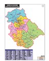 | 1,122 × 1,406 (968 KB) | Rvd4life | =={{int:filedesc}}== {{Information |description={{en|1=Map of new assembly constituencies for the union territory of Jammu and Kashmir.}} |date={{other date|?}} |source= https://web.archive.org/web/20230524150644/https://ceojk.nic.in/pdf/J&K%20AC%20map%20new.pdf |author=Government of Jammu and Kashmir (Chief Electoral Officer), India |permission= |other versions= }} =={{int:license-header}}== {{GODL-India}} [[Category:]] |
File usage
The following pages on the English Wikipedia use this file (pages on other projects are not listed):
Global file usage
The following other wikis use this file:
- Usage on hi.wikipedia.org
- Usage on te.wikipedia.org
Metadata
This file contains additional information, probably added from the digital camera or scanner used to create or digitize it.
If the file has been modified from its original state, some details may not fully reflect the modified file.
| Short title | JK Maps.pdf |
|---|---|
| Image title | avepdf.com - Free Online PDF and Document Tools |
| Author | anils |
| Conversion program | Microsoft: Print To PDF |
| Encrypted | no |
| Page size | 539.627 x 675.047 pts |
| Version of PDF format | 1.7 |
Retrieved from "https://en.wikipedia.org/wiki/File:J%26K_AC_map_new.pdf"