File:Guang_yu_tu_-_er_juan_LOC_2008623187-2.jpg
From Wikipedia, the free encyclopedia

Original file (4,380 × 4,658 pixels, file size: 4.55 MB, MIME type: image/jpeg)
| This is a file from the Wikimedia Commons. Information from its description page there is shown below. Commons is a freely licensed media file repository. You can help. |
Summary
| DescriptionGuang yu tu - er juan LOC 2008623187-2.jpg |
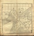
English: Guang Yutu, Map 62. 1st Map of the Liaodong area of the Ming Empire, now Liaoning Province. Great Wall and Willow Palisade shown. Grids of 100 li square (roughly 30×30 km or about 20×20 miles). LOC copy with some damage.
中文:《廣輿圖·第六十二·遼東𫟪圖一·每方百里》 |
||
| Title InfoField | English: Map 62: Liaoning Map 1
中文:《廣輿圖·第六十二·遼東𫟪圖一·每方百里》 |
||
| Shelf ID InfoField | G2305 .L6 1558 B182.07 L78.1 | ||
| Parent InfoField | https://www.loc.gov/resource/lcnclscd.2008623187.1A002/ | ||
| Sheet title InfoField | Image 2 of Volume 2 | ||
| Date | |||
| Source | LOC | ||
| Author | Zhu Siben, edited and updated by Luo Hongxian | ||
| Permission (Reusing this file) |
|
||
| Other versions |
|
||
| Location InfoField | China | ||
| Part of InfoField | Catalog · Asian · Chinese Rare Book Digital Collection · Asian Division | ||
| Subject InfoField | Historical Geography · Defenses · Boundaries · Maps · Early Works To 1800 · China · Administrative And Political Divisions |


Licensing
|
This is a faithful photographic reproduction of a two-dimensional, public domain work of art. The work of art itself is in the public domain for the following reason:
The official position taken by the Wikimedia Foundation is that "faithful reproductions of two-dimensional public domain works of art are public domain".
This photographic reproduction is therefore also considered to be in the public domain in the United States. In other jurisdictions, re-use of this content may be restricted; see Reuse of PD-Art photographs for details. | |||||
| Annotations InfoField | This image is annotated: View the annotations at Commons |
百每
里方
100 Li per Square
六
十
二
p. 62
鸭
緑
江
Yalu River
海
関
介
Shanhaiguan
遼
東
𫟪
圖
一
Liaodong Map 1
遼
河
Liao River
Captions
Items portrayed in this file
depicts
image/jpeg
File history
Click on a date/time to view the file as it appeared at that time.
| Date/Time | Thumbnail | Dimensions | User | Comment | |
|---|---|---|---|---|---|
| current | 15:36, 12 May 2019 | | 4,380 × 4,658 (4.55 MB) | Fæ | LOC Maps multisheet https://www.loc.gov/item/2008623187/ sheet 2 of 61 #3990 |