File:Fiji_map.png
From Wikipedia, the free encyclopedia
No higher resolution available.
Fiji_map.png (324 × 349 pixels, file size: 11 KB, MIME type: image/png)
| This is a file from the Wikimedia Commons. Information from its description page there is shown below. Commons is a freely licensed media file repository. You can help. |

|
This map has been uploaded by Electionworld from en.wikipedia.org to enable the |
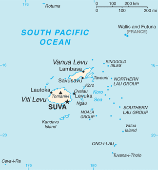
PNG map of Fiji from CIA World Factbook.
| Public domainPublic domainfalsefalse |
This image is in the public domain because it contains materials that originally came from the United States Central Intelligence Agency's World Factbook.
Bahasa Indonesia ∙ čeština ∙ Deutsch ∙ eesti ∙ English ∙ español ∙ Esperanto ∙ français ∙ galego ∙ hrvatski ∙ italiano ∙ Nederlands ∙ norsk nynorsk ∙ polski ∙ português ∙ sicilianu ∙ slovenščina ∙ suomi ∙ Türkçe ∙ Zazaki ∙ беларуская (тарашкевіца) ∙ македонски ∙ русский ∙ српски / srpski ∙ українська ∙ ქართული ∙ বাংলা ∙ தமிழ் ∙ മലയാളം ∙ 한국어 ∙ 日本語 ∙ 中文 ∙ 中文(简体) ∙ 中文(繁體) ∙ العربية ∙ +/− |
 |
Originally uploaded to English Wikipedia by en:User:Grendelkhan as Fj-map.png.

|
This map image could be re-created using vector graphics as an SVG file. This has several advantages; see Commons:Media for cleanup for more information. If an SVG form of this image is available, please upload it and afterwards replace this template with
{{vector version available|new image name}}.
It is recommended to name the SVG file “Fiji map.svg”—then the template Vector version available (or Vva) does not need the new image name parameter. |
Captions
map of Fiji
Τα νησιά Φίτνησζι
File history
Click on a date/time to view the file as it appeared at that time.
| Date/Time | Thumbnail | Dimensions | User | Comment | |
|---|---|---|---|---|---|
| current | 13:26, 1 May 2013 | | 324 × 349 (11 KB) | Ras67 | cropped |
| 17:14, 16 September 2012 |  | 328 × 353 (23 KB) | Thricecube | Updated version | |
| 17:33, 26 June 2012 |  | 326 × 351 (4 KB) | Ras67 | cropped | |
| 03:18, 12 March 2005 |  | 330 × 355 (4 KB) | Alexander Ilnitsky~commonswiki | Map of Fiji |
File usage
The following pages on the English Wikipedia use this file (pages on other projects are not listed):
- Cikobia-i-Lau
- Cikobia-i-Ra
- Fiji
- January 2012 Fiji floods
- Koro Island
- Lahloo (clipper)
- Lautoka
- List of birds of Fiji
- List of twin towns and sister cities in Fiji
- Lomaiviti Islands
- Moala Island
- Nadroga-Navosa Province
- Naval Base Fiji
- Rotuma
- Suva
- Vanua Levu
- Vatulele
- Viti Levu
- User:D3adman5225/sandbox
- User:JJ.SS123.123.123/sandbox
Global file usage
The following other wikis use this file:
- Usage on af.wikipedia.org
- Usage on als.wikipedia.org
- Usage on am.wikipedia.org
- Usage on ang.wikipedia.org
- Usage on ar.wikipedia.org
- Usage on ast.wikipedia.org
- Usage on azb.wikipedia.org
- Usage on az.wikipedia.org
- Usage on ban.wikipedia.org
- Usage on bar.wikipedia.org
- Usage on ba.wikipedia.org
- Usage on bcl.wikipedia.org
- Usage on be-tarask.wikipedia.org
- Usage on bn.wikipedia.org
- Usage on br.wikipedia.org
- Usage on ca.wikipedia.org
- Usage on ceb.wikipedia.org
- Usage on cs.wikipedia.org
- Usage on cy.wikipedia.org
- Usage on de.wikipedia.org
- Usage on de.wikivoyage.org
- Usage on dsb.wikipedia.org
- Usage on el.wikipedia.org
- Usage on en.wikibooks.org
- Usage on en.wikiversity.org
- Usage on eo.wikipedia.org
View more global usage of this file.
Retrieved from "https://en.wikipedia.org/wiki/File:Fiji_map.png"