File:Enchanted_rock_2006.jpg
From Wikipedia, the free encyclopedia
Enchanted_rock_2006.jpg (640 × 480 pixels, file size: 59 KB, MIME type: image/jpeg)
| This is a file from the Wikimedia Commons. Information from its description page there is shown below. Commons is a freely licensed media file repository. You can help. |
Summary
|
This is an image of a place or building that is listed on the National Register of Historic Places in the United States of America. Its reference number is 84001740. |
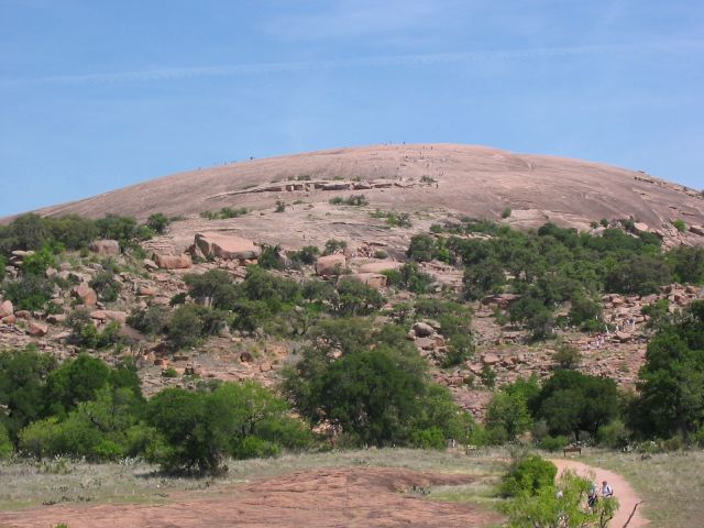
| DescriptionEnchanted rock 2006.jpg |
Enchanted Rock as viewed from the trail leading to the summit. People climbing on the summit (visible as dots) give an idea of the scale of the granite rock. Source: Photo taken by uploader, April 14, 2006. |
| Date | 18 April 2006 (original upload date) |
| Source | Transferred from en.wikipedia to Commons. |
| Author | Claygate at English Wikipedia |
| Object location | 30° 30′ 20″ N, 98° 49′ 05″ W | View this and other nearby images on: OpenStreetMap |
|---|
Licensing
| Public domainPublic domainfalsefalse |
| This work has been released into the public domain by its author, Claygate at English Wikipedia. This applies worldwide. In some countries this may not be legally possible; if so: Claygate grants anyone the right to use this work for any purpose, without any conditions, unless such conditions are required by law.Public domainPublic domainfalsefalse |
Original upload log
- 2006-04-18 01:13 Claygate 640×480×8 (60062 bytes) Picture taken by uploader, April 14, 2006.
Captions
Items portrayed in this file
depicts
18 April 2006
30°30'20.002"N, 98°49'5.002"W
image/jpeg
File history
Click on a date/time to view the file as it appeared at that time.
| Date/Time | Thumbnail | Dimensions | User | Comment | |
|---|---|---|---|---|---|
| current | 02:04, 24 April 2007 | | 640 × 480 (59 KB) | Jomegat | {{Information |Description=Enchanted Rock as viewed from the trail leading to the summit. People climbing on the summit (visible as dots) give an idea of the scale of the granite rock. Source: Photo taken by uploader, April 14, 2006. |Source=Originally f |
File usage
- Enchanted Rock
- List of National Natural Landmarks in Texas
- List of Texas state parks
- Llano, Texas
- Llano Uplift
- National Register of Historic Places listings in Gillespie County, Texas
- National Register of Historic Places listings in Llano County, Texas
- National Register of Historic Places listings in the Alamo region of Texas: Other
- National Register of Historic Places listings in the Capital region of Texas: Other
Global file usage
The following other wikis use this file:
- Usage on bar.wikipedia.org
- Usage on de.wikipedia.org
- Usage on en.wikibooks.org
- Usage on es.wikipedia.org
- Usage on fa.wikipedia.org
- Usage on fr.wikipedia.org
- Usage on it.wikipedia.org
- Usage on nl.wikipedia.org
- Usage on sv.wikipedia.org
- Usage on zh.wikipedia.org
Metadata
This file contains additional information, probably added from the digital camera or scanner used to create or digitize it.
If the file has been modified from its original state, some details may not fully reflect the modified file.
| _error | 0 |
|---|