File:Colonial_Africa_1914_map.png
From Wikipedia, the free encyclopedia
No higher resolution available.
Colonial_Africa_1914_map.png (288 × 337 pixels, file size: 13 KB, MIME type: image/png)
| This is a file from the Wikimedia Commons. Information from its description page there is shown below. Commons is a freely licensed media file repository. You can help. |
Summary
| DescriptionColonial Africa 1914 map.png |
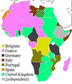
English: Map of colonial Africa in 1914. Deutsch: Karte des kolonialen Afrika in 1914. Italiano: Mappa dell'Africa coloniale nel 1914, in inglese. Español: Mapa del África colonial en el 1914, en inglés. |
|||||
| Date | ||||||
| Source | Own work (Based on this blank map of Africa) | |||||
| Author | original version by Declan Graham, revised by Lucy | |||||
| Other versions |
|


.svg)

_ast.svg)


-es.svg)
_mapa.png)

_eu.svg)


.svg)

.jpg)


-sr.png)


.svg)


.svg)

Licensing
I, the copyright holder of this work, hereby publish it under the following licenses:

|
Permission is granted to copy, distribute and/or modify this document under the terms of the GNU Free Documentation License, Version 1.2 or any later version published by the Free Software Foundation; with no Invariant Sections, no Front-Cover Texts, and no Back-Cover Texts. A copy of the license is included in the section entitled GNU Free Documentation License.http://www.gnu.org/copyleft/fdl.htmlGFDLGNU Free Documentation Licensetruetrue |
This file is licensed under the Creative Commons Attribution-Share Alike 3.0 Unported, 2.5 Generic, 2.0 Generic and 1.0 Generic license.
- You are free:
- to share – to copy, distribute and transmit the work
- to remix – to adapt the work
- Under the following conditions:
- attribution – You must give appropriate credit, provide a link to the license, and indicate if changes were made. You may do so in any reasonable manner, but not in any way that suggests the licensor endorses you or your use.
- share alike – If you remix, transform, or build upon the material, you must distribute your contributions under the same or compatible license as the original.
You may select the license of your choice.
Captions
Add a one-line explanation of what this file represents
Mapa Afryki kolonialnej w 1914 roku.
Items portrayed in this file
depicts
31 December 2006
image/png
6356b04f0072227e973e1f2638af40cb7edfd565
13,062 byte
337 pixel
288 pixel
File history
Click on a date/time to view the file as it appeared at that time.
| Date/Time | Thumbnail | Dimensions | User | Comment | |
|---|---|---|---|---|---|
| current | 02:20, 1 November 2021 | | 288 × 337 (13 KB) | Randomastwritter | jubaland |
| 14:04, 1 June 2019 |  | 288 × 337 (10 KB) | SuperSucker | better | |
| 03:31, 31 May 2019 |  | 288 × 337 (13 KB) | SuperSucker | Reverted to version as of 19:15, 14 February 2018 (UTC) ouch.. not before WW1 though | |
| 02:21, 31 May 2019 |  | 288 × 337 (7 KB) | SuperSucker | Ethiopia colonized by Italy right before WW2 - unclear why this file and others made as well in 2006 always neglect it (probably because of the football soccer cup conquered on that exact summer) | |
| 19:15, 14 February 2018 |  | 288 × 337 (13 KB) | Knyaz-1988 | Новая версия | |
| 21:38, 13 February 2018 |  | 288 × 337 (13 KB) | Knyaz-1988 | Новая версия | |
| 17:01, 13 February 2018 |  | 288 × 337 (12 KB) | Knyaz-1988 | Новая версия | |
| 21:52, 22 September 2015 |  | 288 × 337 (13 KB) | Knyaz-1988 | Новая версия | |
| 17:52, 14 March 2015 |  | 288 × 337 (13 KB) | Knyaz-1988 | Новая версия | |
| 21:27, 2 March 2015 |  | 288 × 337 (13 KB) | Knyaz-1988 | Новая версия |
File usage
The following pages on the English Wikipedia use this file (pages on other projects are not listed):
Global file usage
The following other wikis use this file:
- Usage on ast.wikipedia.org
- Usage on ba.wikipedia.org
- Usage on bn.wikipedia.org
- Usage on ca.wikipedia.org
- Usage on de.wikipedia.org
- Usage on diq.wikipedia.org
- Usage on el.wikivoyage.org
- Usage on eml.wikipedia.org
- Usage on en.wikiquote.org
- Usage on en.wikivoyage.org
- Usage on en.wiktionary.org
- Usage on et.wikipedia.org
- Usage on eu.wikipedia.org
- Usage on fa.wikivoyage.org
- Usage on fi.wikipedia.org
- Usage on fi.wikibooks.org
- Usage on fr.wikipedia.org
- Usage on fr.wikivoyage.org
- Usage on gl.wikipedia.org
- Usage on gn.wikipedia.org
- Usage on he.wikipedia.org
- Usage on hi.wikipedia.org
- Usage on hr.wikipedia.org
- Usage on hu.wikipedia.org
- Usage on it.wikipedia.org
- Usage on it.wikiversity.org
- Usage on ja.wikipedia.org
- Usage on kk.wikipedia.org
- Usage on ko.wikipedia.org
- Usage on li.wiktionary.org
- Usage on nl.wikipedia.org
- Usage on nn.wikipedia.org
- Usage on no.wikipedia.org
- Usage on pam.wikipedia.org
- Usage on pt.wikipedia.org
- Usage on ro.wikipedia.org
- Usage on ru.wikipedia.org
- Usage on scn.wikipedia.org
- Usage on sh.wikipedia.org
- Usage on simple.wikipedia.org
View more global usage of this file.
Metadata
This file contains additional information, probably added from the digital camera or scanner used to create or digitize it.
If the file has been modified from its original state, some details may not fully reflect the modified file.
| Horizontal resolution | 47.24 dpc |
|---|---|
| Vertical resolution | 47.24 dpc |
Retrieved from "https://en.wikipedia.org/wiki/File:Colonial_Africa_1914_map.png"