File:Cnicht,_NE_top_-_geograph.org.uk_-_440414.jpg
From Wikipedia, the free encyclopedia
No higher resolution available.
Cnicht,_NE_top_-_geograph.org.uk_-_440414.jpg (640 × 480 pixels, file size: 80 KB, MIME type: image/jpeg)
| This is a file from the Wikimedia Commons. Information from its description page there is shown below. Commons is a freely licensed media file repository. You can help. |
Summary
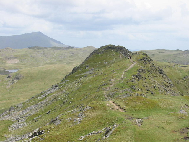
| DescriptionCnicht, NE top - geograph.org.uk - 440414.jpg |
English: Cnicht, NE top, 3 km from Croesor, Gwynedd, Wales.
Moel Siabod in the background |
| Date | |
| Source | From this image at geograph.org.uk; transferred by User:RHaworth using geograph_org2commons. |
| Author | Dewi |
| Permission (Reusing this file) |
Creative Commons Attribution Share-alike license 2.0 |
| Attribution (required by the license) InfoField | Dewi / Cnicht, NE top / |
InfoField | Dewi / Cnicht, NE top |
| Camera location | 53° 00′ 01.32″ N, 4° 01′ 07.66″ W | View this and other nearby images on: OpenStreetMap |
|---|
| Object location | 53° 00′ 08″ N, 4° 00′ 57″ W | View this and other nearby images on: OpenStreetMap |
|---|
Licensing

|
This image was taken from the Geograph project collection. See this photograph's page on the Geograph website for the photographer's contact details. The copyright on this image is owned by Dewi and is licensed for reuse under the Creative Commons Attribution-ShareAlike 2.0 license.
|
This file is licensed under the Creative Commons Attribution-Share Alike 2.0 Generic license.
Attribution: Dewi
- You are free:
- to share – to copy, distribute and transmit the work
- to remix – to adapt the work
- Under the following conditions:
- attribution – You must give appropriate credit, provide a link to the license, and indicate if changes were made. You may do so in any reasonable manner, but not in any way that suggests the licensor endorses you or your use.
- share alike – If you remix, transform, or build upon the material, you must distribute your contributions under the same or compatible license as the original.
Captions
Add a one-line explanation of what this file represents
Items portrayed in this file
depicts
20 May 2007
53°0'1.325"N, 4°1'7.662"W
53°0'8.46"N, 4°0'56.52"W
image/jpeg
a2ea11235e4b1eef53ee51f89ef916c5677ea10e
81,949 byte
480 pixel
640 pixel
File history
Click on a date/time to view the file as it appeared at that time.
| Date/Time | Thumbnail | Dimensions | User | Comment | |
|---|---|---|---|---|---|
| current | 05:26, 22 April 2010 | | 640 × 480 (80 KB) | File Upload Bot (Magnus Manske) | == {{int:filedesc}} == {{Information |Description={{en|1=Cnicht, NE top, 3 km from Croesor, Gwynedd, Great Britain. Moel Siabod in the background}} |Source=From [http://www.geograph.org.uk/photo/440414 this image] at [http://geograph.org.uk geograph.org.u |
File usage
The following pages on the English Wikipedia use this file (pages on other projects are not listed):
Global file usage
The following other wikis use this file:
- Usage on cy.wikipedia.org
- Usage on www.wikidata.org
Metadata
This file contains additional information, probably added from the digital camera or scanner used to create or digitize it.
If the file has been modified from its original state, some details may not fully reflect the modified file.
| Camera manufacturer | Canon |
|---|---|
| Camera model | Canon PowerShot A20 |
| Exposure time | 1/125 sec (0.008) |
| F-number | f/13 |
| Date and time of data generation | 11:21, 20 May 2007 |
| Lens focal length | 13.4375 mm |
| Orientation | Normal |
| Horizontal resolution | 180 dpi |
| Vertical resolution | 180 dpi |
| File change date and time | 11:21, 20 May 2007 |
| Y and C positioning | Centered |
| Exif version | 2.1 |
| Date and time of digitizing | 11:21, 20 May 2007 |
| Image compression mode | 2 |
| Shutter speed | 6.96875 |
| APEX aperture | 7.40625 |
| Exposure bias | 0 |
| Maximum land aperture | 2.9708557128906 APEX (f/2.8) |
| Subject distance | 65.535 meters |
| Metering mode | Pattern |
| Flash | Flash did not fire |
| Color space | sRGB |
| Focal plane X resolution | 4,970.8737864078 |
| Focal plane Y resolution | 4,954.8387096774 |
| Focal plane resolution unit | inches |
| Sensing method | One-chip color area sensor |