File:Cartogram-2008_Electoral_Vote.png
From Wikipedia, the free encyclopedia
Size of this preview: 705 × 599 pixels. Other resolutions: 282 × 240 pixels | 565 × 480 pixels | 1,000 × 850 pixels.
Original file (1,000 × 850 pixels, file size: 56 KB, MIME type: image/png)
| This is a file from the Wikimedia Commons. Information from its description page there is shown below. Commons is a freely licensed media file repository. You can help. |

|
File:Cartogram-2008 Electoral Vote.svg is a vector version of this file. It should be used in place of this PNG file when not inferior.
File:Cartogram-2008 Electoral Vote.png → File:Cartogram-2008 Electoral Vote.svg
For more information, see Help:SVG.
|
 |
Summary
| DescriptionCartogram-2008 Electoral Vote.png |
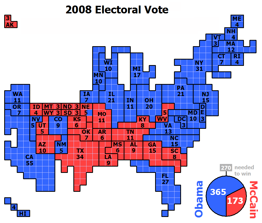
English: Cartogram of the 2008 Electoral Vote for US President, with each square representing one electoral vote. Nebraska, being one of two states that are not winner-take-all, for the first time had its votes split, with NE-2 voting for Obama and the rest of the state for McCain. The population density of the 50 states varies by three orders of magnitude (from NJ with nearly 1,200 people per square mile, to AK with roughly 1 1/4 people per sq mi). Because of that huge variation, a regular map of the US that is typically used to present electoral vote results can convey a very skewed impression of the outcome where sparsely populated states appear overrepresented and densely populated states appear underrepresented. The cartogram approach of this image eliminates that problem by presenting the area of each state in an exact one-to-one correspondence with its number of electoral votes. But this is achieved at the cost of introducing distortions to the actual shape of each state and their positioning in relation to each other. |
| Date | |
| Source | Own work by uploader (created with Powerpoint) |
| Author | ChrisnHouston |
| Other versions |
Derivative works of this file: Cartogram-2008 Electoral Vote-es.svg Cartogram-2008 Electoral Vote.gif |
Licensing
I, the copyright holder of this work, hereby publish it under the following licenses:
This file is licensed under the Creative Commons Attribution-Share Alike 3.0 Unported license.
- You are free:
- to share – to copy, distribute and transmit the work
- to remix – to adapt the work
- Under the following conditions:
- attribution – You must give appropriate credit, provide a link to the license, and indicate if changes were made. You may do so in any reasonable manner, but not in any way that suggests the licensor endorses you or your use.
- share alike – If you remix, transform, or build upon the material, you must distribute your contributions under the same or compatible license as the original.

|
Permission is granted to copy, distribute and/or modify this document under the terms of the GNU Free Documentation License, Version 1.2 or any later version published by the Free Software Foundation; with no Invariant Sections, no Front-Cover Texts, and no Back-Cover Texts. A copy of the license is included in the section entitled GNU Free Documentation License.http://www.gnu.org/copyleft/fdl.htmlGFDLGNU Free Documentation Licensetruetrue |
You may select the license of your choice.
Captions
Add a one-line explanation of what this file represents
Items portrayed in this file
depicts
some value
8 November 2008
image/png
2a0f400165722d52d7df3805c8d4629b0871cba9
57,519 byte
850 pixel
1,000 pixel
File history
Click on a date/time to view the file as it appeared at that time.
| Date/Time | Thumbnail | Dimensions | User | Comment | |
|---|---|---|---|---|---|
| current | 03:59, 9 January 2009 | | 1,000 × 850 (56 KB) | ChrisnHouston | {{Information |Description=Cartogram of the 2008 Electoral Vote for US President, with each square representing one electoral vote. Nebraska, being one of two states that are not winner-take-all, for the first time had its votes split, with NE-2 voting fo |
| 22:03, 19 November 2008 |  | 1,000 × 850 (61 KB) | Collegebookworm | update of existing cartogram for missouri projections | |
| 23:18, 10 November 2008 |  | 1,000 × 850 (39 KB) | ChrisnHouston | {{Information |Description={{en|1=Cartogram of the projected 2008 Electoral Vote for US President (based on popular vote) with each square representing one electoral vote. Nebraska, being one of two states that are not winner-take-all, for the first time |
File usage
The following pages on the English Wikipedia use this file (pages on other projects are not listed):
Global file usage
The following other wikis use this file:
- Usage on es.wikipedia.org
- Usage on ja.wikipedia.org
- Usage on mk.wikipedia.org
- Usage on no.wikipedia.org
- Usage on ru.wikipedia.org
- Usage on vi.wikipedia.org
Retrieved from "https://en.wikipedia.org/wiki/File:Cartogram-2008_Electoral_Vote.png"