File:Canada_provinces_1927-1949.png
From Wikipedia, the free encyclopedia
Size of this preview: 694 × 600 pixels. Other resolutions: 278 × 240 pixels | 556 × 480 pixels | 1,000 × 864 pixels.
Original file (1,000 × 864 pixels, file size: 61 KB, MIME type: image/png)
| This is a file from the Wikimedia Commons. Information from its description page there is shown below. Commons is a freely licensed media file repository. You can help. |
Summary
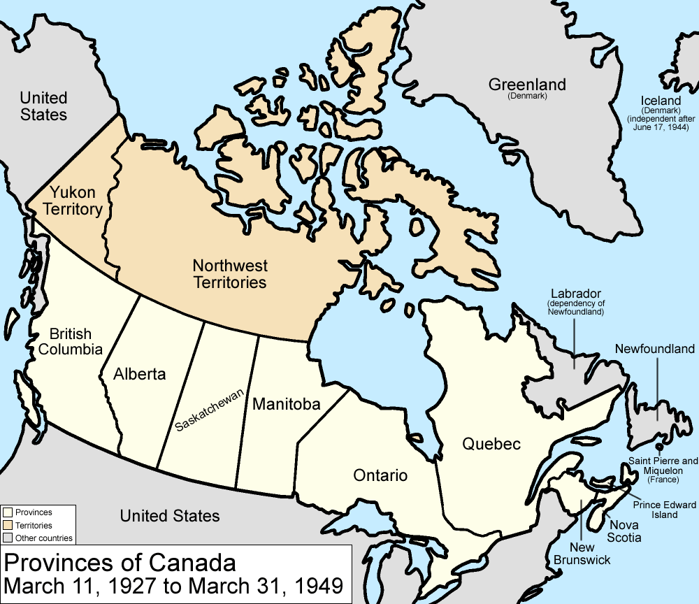
| DescriptionCanada provinces 1927-1949.png |
Map of the provinces and territories of Canada as they were between 1927 and 1949. On March 1 1927, a court transferred a disputed portion of Quebec to the Dominion of Newfoundland. On March 31 1949, Newfoundland joined Canada as a province. Made by User:Golbez. |
| Date | 13 February 2006 (original upload date) |
| Source | No machine-readable source provided. Own work assumed (based on copyright claims). |
| Author | No machine-readable author provided. Golbez assumed (based on copyright claims). |
Licensing
I, the copyright holder of this work, hereby publish it under the following licenses:

|
Permission is granted to copy, distribute and/or modify this document under the terms of the GNU Free Documentation License, Version 1.2 or any later version published by the Free Software Foundation; with no Invariant Sections, no Front-Cover Texts, and no Back-Cover Texts. A copy of the license is included in the section entitled GNU Free Documentation License.http://www.gnu.org/copyleft/fdl.htmlGFDLGNU Free Documentation Licensetruetrue |
| This file is licensed under the Creative Commons Attribution-Share Alike 3.0 Unported license. | ||
| ||
| This licensing tag was added to this file as part of the GFDL licensing update.http://creativecommons.org/licenses/by-sa/3.0/CC BY-SA 3.0Creative Commons Attribution-Share Alike 3.0truetrue |
This file is licensed under the Creative Commons Attribution 2.5 Generic license.
- You are free:
- to share – to copy, distribute and transmit the work
- to remix – to adapt the work
- Under the following conditions:
- attribution – You must give appropriate credit, provide a link to the license, and indicate if changes were made. You may do so in any reasonable manner, but not in any way that suggests the licensor endorses you or your use.
You may select the license of your choice.
Captions
Add a one-line explanation of what this file represents
Items portrayed in this file
depicts
13 February 2006
image/png
ae3e32402a2c6f17acea7bced4a7cddb76dd9dbd
62,120 byte
864 pixel
1,000 pixel
File history
Click on a date/time to view the file as it appeared at that time.
| Date/Time | Thumbnail | Dimensions | User | Comment | |
|---|---|---|---|---|---|
| current | 17:22, 14 July 2009 | | 1,000 × 864 (61 KB) | Golbez | New color scheme, other borders |
| 09:59, 7 August 2006 |  | 1,000 × 864 (47 KB) | Golbez | with legend | |
| 02:25, 18 February 2006 |  | 1,000 × 864 (46 KB) | Golbez | Better version | |
| 23:49, 13 February 2006 |  | 1,000 × 864 (41 KB) | Golbez | better colors | |
| 06:35, 13 February 2006 |  | 1,000 × 864 (41 KB) | Golbez | Map of the provinces and territories of Canada as they were between 1927 and 1949. On March 1 1927, a court transferred a disputed portion of Quebec to the Dominion of Newfoundland. On March 31 1949, Newfoundland joined Canada as a province. Made by [[U |
File usage
The following pages on the English Wikipedia use this file (pages on other projects are not listed):
Global file usage
The following other wikis use this file:
- Usage on de.wikipedia.org
- Usage on es.wikipedia.org
- Usage on fr.wikipedia.org
- Usage on it.wikipedia.org
- Usage on pt.wikipedia.org
- Usage on ru.wikipedia.org
- Usage on uk.wikipedia.org
- Usage on vi.wikipedia.org
- Usage on zh.wikipedia.org
Retrieved from "https://en.wikipedia.org/wiki/File:Canada_provinces_1927-1949.png"