File:AshfieldNSWsatellite.jpg
From Wikipedia, the free encyclopedia
Size of this preview: 800 × 597 pixels. Other resolutions: 320 × 239 pixels | 640 × 477 pixels | 893 × 666 pixels.
Original file (893 × 666 pixels, file size: 335 KB, MIME type: image/jpeg)
| This is a file from the Wikimedia Commons. Information from its description page there is shown below. Commons is a freely licensed media file repository. You can help. |
Summary
| DescriptionAshfieldNSWsatellite.jpg |
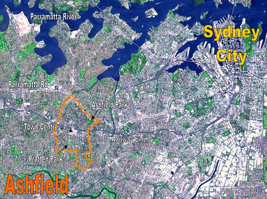
English: Location Map for the suburb of Ashfield, NSW based on NASA satellite map. Modified to identify suburb boundaries and identifiable landmarks. |
| Date | |
| Source | Based on http://photojournal.jpl.nasa.gov/catalog/PIA03498 |
| Author | NASA with adaptations by Crico at en.wikipedia, based on a NASA picture. |
Licensing
| Public domainPublic domainfalsefalse |
| This file is in the public domain in the United States because it was solely created by NASA. NASA copyright policy states that "NASA material is not protected by copyright unless noted". (See Template:PD-USGov, NASA copyright policy page or JPL Image Use Policy.) | ||
 |
Warnings:
|
Original upload log
The original description page was here. All following user names refer to en.wikipedia.
- 2007-03-23 04:10 Crico 893×666× (342878 bytes) Location Map for the suburb of Ashfield, NSW based on NASA satellite map. Modified to identify suburb boundaries and identifiable landmarks. Original NASA image number: [[:Image:PIA03498.jpg|PIA03498]] {{PD-USGov-NASA}}
Captions
Add a one-line explanation of what this file represents
Items portrayed in this file
depicts
23 March 2007
image/jpeg
b2f346fd33ca223ef23cceea99ce4fba94117b48
342,878 byte
666 pixel
893 pixel
File history
Click on a date/time to view the file as it appeared at that time.
| Date/Time | Thumbnail | Dimensions | User | Comment | |
|---|---|---|---|---|---|
| current | 23:18, 28 February 2009 | | 893 × 666 (335 KB) | File Upload Bot (Magnus Manske) | {{BotMoveToCommons|en.wikipedia|year={{subst:CURRENTYEAR}}|month={{subst:CURRENTMONTHNAME}}|day={{subst:CURRENTDAY}}}} {{Information |Description={{en|Location Map for the suburb of Ashfield, NSW based on NASA satellite map. Modified to identify suburb b |
File usage
The following pages on the English Wikipedia use this file (pages on other projects are not listed):
Global file usage
The following other wikis use this file:
- Usage on fr.wikipedia.org
Metadata
This file contains additional information, probably added from the digital camera or scanner used to create or digitize it.
If the file has been modified from its original state, some details may not fully reflect the modified file.
| _error | 0 |
|---|
Retrieved from "https://en.wikipedia.org/wiki/File:AshfieldNSWsatellite.jpg"